TASMANIAN ROUTES
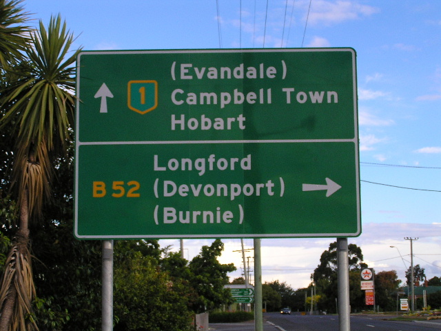
A sample of route marking in Tasmania - National Highway 1 and route B52 at their junction in Perth. Source: Josh Geoghegan, Dec 2004.
Tasmania operates with an alpha-numeric route marking system, the first state to do so, with the exception of one route – National Highway 1. This is a historic anomaly, necessitated by a Federal Government requirement, when the system was introduced, that the National Highway route be signed with the traditional National Highway shield. The Department of Energy, Infrastructure and Resources (DIER) stresses that the system is simply a route numbering system, and thus the category of a route does not reflect the road condition or pavement standard to be expected. A classic example is route A5, which is unsealed for a considerable length through the Highland Lakes region.
The official name of the system is the ‘Route CodeNumbering System’ and it is based on the system that was implemented in the United Kingdom in 1922, whereby eight zones were created and chosen according to their importance to visitors. The zones have their boundaries on the major highway network, thereby dividing the state into eight zones. The selection of route numbers within the zones has no definite pattern, however they have been chosen from adjacent highway numbers where possible.
The system divides routes into the following four categories:
- The National Highway, which is identified by the National Highway Shield
- ‘A’ Routes, which are those roads considered to be of the greatest importance as major arterials and in the main comprise State Highways
- ‘B’ Routes, which are the sub-arterials or roads strategically located so as to form a connecting link between A Routes or towns and key centres
- ‘C’ Routes, being those other minor roads within the State considered to be of sufficient importance to be included in the network. In the main, these ‘C’ routes are roads under the control of local government or government authorities such as Forestry Tasmania
The DIER is responsible for the maintenance and renewal of alpha-numeric signs on classified roads and on all other roads the road authority is responsible for maintaining the signs. Cooperation of all road authorities is therefore required to ensure the integrity of the system and it signposting.
The system is generally made up on 1-digit ‘A’ Routes (including 10 as well), 2-digit ‘B’ Routes, and 3-digit ‘C’ routes. However, there are two anomalies. Route B10 between Bridgewater and New Norfolk forms an alternative to the A10 (Lyell Highway) on the northern side of the Derwent River. Route B110 is the only 3-digit ‘B’ route and is a link between the A10 (Lyell Highway) and A5 (Lake Secondary Road) in the Highland Lakes region. There doesn’t appear to be any obvious reason for the existence of B110, other than perhaps they ran out of B1x numbers for that zone’s ‘B’ Routes.
Background
Prior to 1979, a system of State Routes existed in Tasmania, based on the State Route Marking principles established by the National Association of Australian State Road Authorities in 1961. More information on this system can be found HERE.
In 1979, the State Government appointed a Road Direction Signs Advisory Council to assist the then Department of Main Roads in the production of a new, preferred system of route marking throughout the state. Shortcomings of the old system had been identified, particularly in the standard of signs and a lack of quality signposting on routes other than those included in the old system.
A system was chosen, based largely on the system that was implemented in the United Kingdom in 1922, and also included a complete restructuring of destination (i.e. focal point) signage across the state. Directional signage standards were based on the 'Worboys' practices brought into use in Britain in 1963, including such features as parenthesis for destinations not directly on the route, and the distinctive black-on-white fingerboards for the minor rural junctions.
The two aims of the new route marking and signposting system were:
- to upgrade the destination signing throughout the State, particularly on unclassified roads
- to give all significant roads a route number so that, with the assistance of route numbered road maps, visitors to an area can navigate their journey with ease by simply following particular route numbers in addition to the usual destination signs giving directions and distances to the various towns, villages, centres of interest, etc.
A trial of the route marking system was undertaken during 1979, using the Arthur Highway (route A9) as a guinea pig. The trial was deemed successful, and the Department of Main Roads moved towards implementation of the system in 1980.
The Department of Main Roads coordinated and funded the installation of the original route marking signs, including those on unclassified roads, but from then on signs on those roads became the responsibility of the respective road authority.
Signposting of the rural route marking system was largely completed by the end of 1983 but it was not until 1986 that signposting in the Hobart and Launceston metropolitan areas was completed. Signposting of local roads was also completed in 1986.
Also possibly associated with the introduction of alpha-numeric route marking was the erection of kilometre plates along the Midland and Bass Highways between Hobart, Launceston and Burnie, during 1988. Other states had been using these signs since at least the introduction of metric distance measurements in 1974.
References
-
Department of Infrastructure, Energy and Resources. 2002. Tasmanian Roadside Signs Manual. Hobart: The Department.
-
Department of Main Roads. 1980-1986. Annual Reports.
-
Department of Transport. 1992. Road Direction Signing: Route Descriptions and Focal Destinations. Hobart: The Department.
-
Personal correspondence with the Department of Infrastructure, Energy and Resources.
List of Tasmanian routes covered by this site
(A comprehensive list of Tasmanian routes will come later)
Hobart - Launceston - Burnie
(includes Brooker Highway, Midland Highway & Bass Highway) |
|
Burnie to Marrawah
(includes Bass Highway) |
|
Hobart to Launceston via East Coast (includes Tasman Highway) |
|
Esk Main Road
(with a spur from St Marys to Tasman Highway via Elephant Pass) |
|
Hobart to Southport
(includes Southern Outlet Highway & Huon Highway) |
|
Launceston to Low Head
(includes East Tamar Highway) |
|
Railton to Devonport, via Sheffield
|
|
Ridgley Highway
|
|
Latrobe to Ulverstone, via Quoiba, Don and Forth
|
|
Cambridge to Mudwalls, via Richmond
|
|
Poatina Main Road
|
|
Illawarra Main Road
|
|
Meander Valley Secondary Road
(former route of Bass Highway) |
|
Bell Bay - Bridport - Gladstone - Tasman Hwy |
|
Former route of Bass Highway through Ulverstone |
|
Former route of Bass Highway through Wynyard |
|
| Nala Rd | |
Mathinna to Fingal |
|
Last updated 11 December 2012 © Ozroads 2003-2012. |