| Glengarry - Winkleigh |

C718 fingerboard at the junction of Winkleigh Rd (C717) & Glengarry Rd (C718), 2km east of Winkleigh. Source: Peter Renshaw, April 2007.
Introduced: 1980
Length: 4km
Northern Terminus: Winkleigh Rd (C717) & Glengarry Rd (C718), 2km east of Winkleigh
Southern Terminus: Frankford Main Rd (B71) & Glengarry Rd (C718), Glengarry
Route taken: Glengarry Rd
Focal Points: Glengarry, Winkleigh
Responsibility: Local Government
C718 is an extremely short rural route, connecting Frankford Main Rd (B71) with Winkleigh Rd (C717) in the West Tamar hinterland. It is signed at both ends of the route, however, up until 2008 the southern end of the route was signed only with the route marker. When signage along Frankford Main Rd was upgraded in the second half of 2008, Winkleigh was added as a focal point for C718 traffic.
C718 is unsealed for most of its short length.
|
Photos of route C718 |
|
 |
Fingerboard signs facing C718 traffic at its northern end - the intersection of Winkleigh Rd (C717) & Glengarry Rd (C718), 2km east of Winkleigh. Source: Peter Renshaw, April 2007. |
|
Fingerboard sign facing southbound C717 traffic, marking the beginning of C718, 2km east of Winkleigh. Source: Peter Renshaw, April 2007. |
 |
Fingerboard signs facing northbound C717 traffic, marking the beginning of C718, 2km east of Winkleigh. Source: Peter Renshaw, June 2007. |
 |
Glengarry Rd (C718) looking north to its northern terminus - the junction with Winkleigh Rd (C717). Source: Peter Renshaw, June 2007. |
 |
Glengarry Rd (C718) looking south from Winkleigh Rd (C717). The gravel begins just over the crest. Source: Peter Renshaw, June 2007. |
 |
Glengarry Rd (C718) looking south - the gravel begins. Source: Peter Renshaw, June 2007. |
 |
Glengarry Rd (C718) looking south to a single-lane crossing of Tunks Cree, near South Winkleigh Rd. Source: Peter Renshaw, June 2007. |
 |
Glengarry Rd (C718) looking south from Tunks Creek - note the very short length of seal only for the crossing of the creek. Source: Peter Renshaw, June 2007. |
 |
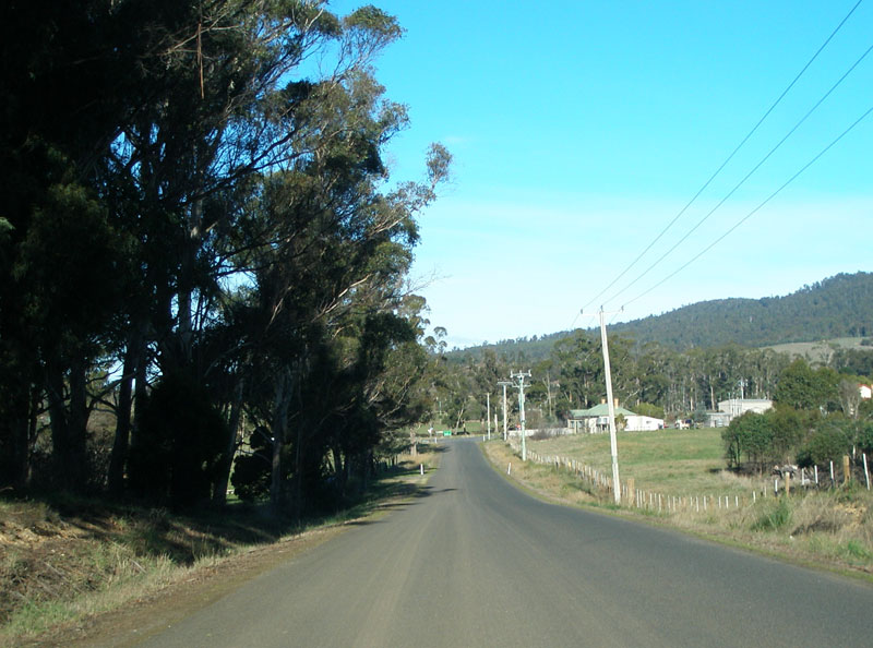
Glengarry Rd (C718) looking south, south of South Winkleigh Rd. Lots of long straights on the well-maintained gravel road. Source: Peter Renshaw, June 2007. |
 |
Seemingly random stretch of seal, about 2.5km south of Winkleigh Road. Source: Peter Renshaw, June 2007. |
 |
Back to the gravel as Glengarry Rd (C718) continues south towards Glengarry. Source: Peter Renshaw, June 2007. |
 |
The seal returns less than a kilometre north of Frankford Main Rd (B71). Source: Peter Renshaw, June 2007. |
 |
Glengarry Rd (C718) looking south on the final stretch with the junction with Frankford Main Rd (B71) in the distance. Source: Peter Renshaw, June 2007. |
 |
Fingerboard signs (and an incorrectly placed distance sign!) at the southern end of C718 - the intersection of Frankford Main Rd (B71) & Glengarry Rd (C718). Note that C718 is signed only with the route marker - why no mention of Winkleigh? Source: Peter Renshaw, April 2007. |
 |
Close-up of the unique-to-Tasmania fingerboard sign with route marker only on it - junction of Frankford Main Rd (B71) & Glengarry Rd (C718). Source: Peter Renshaw, June 2007. |
 |
Renewed fingerboard sign assembly at the intersection of Frankford Main Rd (B71) & Glengarry Rd (C718), with the inclusion of Winkleigh as a focal point for C718. Source: Peter Renshaw, October 2008. |
 |
AD sign eastbound on Frankford Main Rd (B71), approaching the junction with Glengarry Rd (C718). This sign was installed in 2008 - previously there were no AD signs for this junction. Source: Peter Renshaw, October 2008. |
 |
AD sign westbound on Frankford Main Rd (B71), approaching the junction with Glengarry Rd (C718). This sign was installed in 2008 - previously there were no AD signs for this junction. Source: Peter Renshaw, October 2008. |
Last updated 26 January 2009. © Ozroads 2004-2009. |