Mathinna to Fingal via Tower Hill Rd |
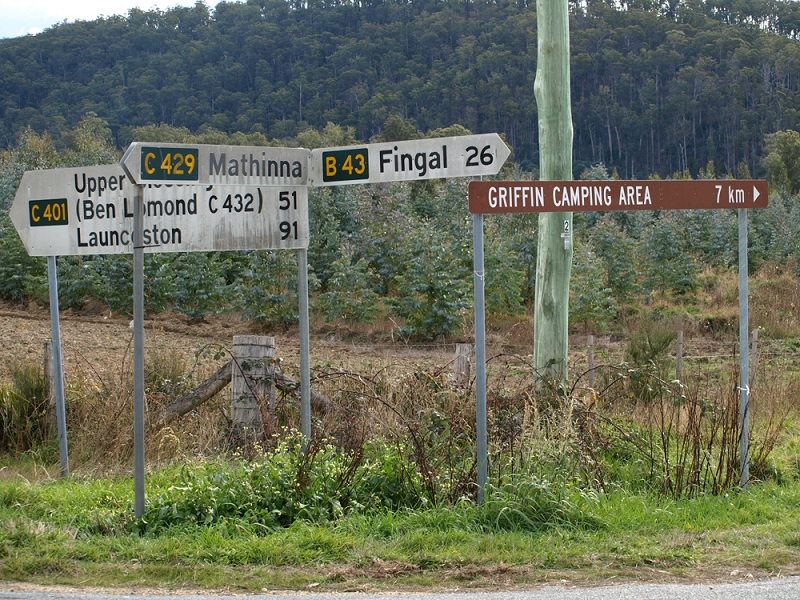
The only current mention of C429 at the junction of Mathinna Rd (B43), Upper Esk Rd (C401), Mathinna Plains Rd (C423) & High St (C429), Mathinna. Source: Peter Renshaw, May 2008.
Introduced: 1980
Length: 24km
Northern Terminus: Mathinna Rd (B43), Upper Esk Rd (C401), Mathinna Plains Rd (C423) & High St (C429), Mathinna
Southern Terminus: Mangana Rd (B42) & Tower Hill Rd (C429), 3km west of Fingal
Route taken: High St, Dunn St, Mangana St, Golden Gate Rd, Tower Hill Rd
Focal Points: Mathinna, (Fingal)
Responsibility: Local Government (Mathinna town street), Forestry Tasmania (remainder of route)
Description:
C429 is the quintessential Tasmanian one-hit wonder. As at December 2012, the only sign mentioning C429 is at the junction at its northern terminus.
The route primarily links Mathinna and Fingal with the old Tower Hill goldfields and a large swathe of State Forest. With the exception of Mathinna town streets, the entire route consists of a narrow, winding gravel road, shared with logging trucks.
C429 commences at the Mathinna cross roads, then heads south through Mathinna townsite. There is an unsignposted dog-leg from High Streets into Dunn and then Mangana Streets to continue southwards - consider this your first challenge. If you can find your way through here without the signs, you're on your way to navigating the entire route. Leaving Mathinna, the gravel road begins and the route enters forestry country. A steep ascent is encountered 2km out of Mathinna before following the ridgeline towards the site of the old Tower Hill goldfields. In the Tower Hill area there are several unsignposted road junctions to navigate. Heading south, the route descends quickly from the ridge to meet Mangana Rd in the Fingal Valley.
Route History:
Presumably at one point the route was reasonably well signposted. However, over the years, the signposting has deteriorated to the current situation where the route is essentially unnavigable by route number.
During the review of route code network by the Road Route Code Advisory Group (RRCAG) in 2011, there was apparently some heated debate as to whether the route should be retained or decommissioned. Forestry Tasmania primarily cited concerns for the safety of motorists who would encounter less than ideal road conditions along the route. Thankfully the decision was made to retain the route, however the signage issues have not yet been addressed.
|
Photos of route C429 |
|
  |
The only current mention of C429 at the junction of Mathinna Rd (B43), Upper Esk Rd (C401), Mathinna Plains Rd (C423) & High St (C429), Mathinna. |
 |
High St (C429) looking south from the Mathinna cross roads into Mathinna. |
 |
A southerly view along Golden Gate Rd (C429), approximately 4km south of Mathinna. |
 |
Tower Hill Rd (C429)looking south approximately 3km north of Mangana Rd (B42). Source: Peter Renshaw, July 2007. |
 |
The southern end of Tower Hill Rd (C429) as it descends to meet Mangana Rd (B42), 3km west of Fingal. Source: Peter Renshaw, July 2007. |
Fingerboard signs at the junction of Mangana Rd (B42) & Tower Hill Rd (C429), 3km west of Fingal. Note the absence of a C429 fingerboard sign - only a standard Forestry Tasmania sign is provided. |
|

Last updated 9 December 2012 © Ozroads 2003-2012. |