Devonport Airport |

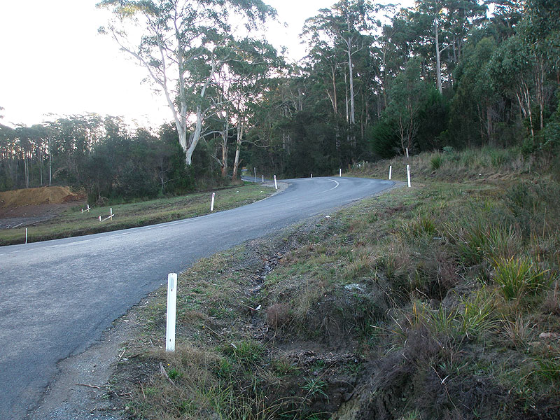
Pardoe Developmental Rd (C701) heading north from the intersection with Port Sorell Main Rd (B74) & Brooke St, 1km south of Devonport Airport. Source: Peter Renshaw, February 2008.
Introduced: 1980
Length: 10km
Northern Terminus: Port Sorell Main Rd (B74) & Pardoe Developmental Rd (C701) & Brooke St, 1km south of Devonport Airport
Southern Terminus: Moriarty Rd (C702) & Wesley Vale Rd (C701), 3km east of Latrobe
Route taken: Pardoe Developmental Rd, Mill Rd, Port Sorell Main Rd, Wesley Vale Rd
Focal Points: (Latrobe), Wesley Vale, Devonport Airport, (Devonport)
Responsibility: State Government (Pardoe Developmental Rd/Port Sorell Main Rd) Local Government (Wesley Vale Rd/Mill Rd)
C701 is a mainly north-south route on the northern coast of Tasmania, linking Latrobe with Wesley Vale and providing access to Devonport Airport. The route is unusual in that it runs north-south from Moriarty Rd (C702) to north of Port Sorell Main Rd (B74) before turning west to Devonport Airport and thence turning south to again intersect with Port Sorell Main Rd (B74).
C701 fulfils a number of functions, including linking Latrobe and the Mersey valley with Port Sorell and associated holiday towns, providing access to and from Devonport Airport, and serving a light industrial area at Wesley Vale which includes a paper mill.
A short duplex along a 50m section of Port Sorell Main Rd (B74) is provided at Wesley Vale, with staggered T-junctions replacing a four-way junction located near a vertical crest and with a poor crash history. The age of the northbound AD sign on Wesley Vale Rd approaching Port Sorell Main Rd suggests that realignment took place in the 1980s. Westwind Dr is the original route of Mill Rd, and it is blocked off at its northern end to prevent its use by through C701 traffic.
At the southern end of the route, Wesley Vale Rd originally met Moriarty Rd (C702) at an oblique Y-junction with a poor crash history. During late 2007, a new intersection and realignment of Wesley Vale Rd was constructed approximately 150m to the west. This work changed the priority of the intersection to make traffic to/from Moriarty Rd east give way to other traffic, and was undertaken with Roads to Recovery funding as part of the development of a preferred route between Latrobe and Port Sorell.
Notable Events:
1980s - Mill Rd realigned to meet Port Sorell Main Rd 50m west of Wesley Vale Rd
1999 - Roundabout constructed at the intersection of Frankford Main Rd & Wesley Vale Rd1
2007 - Intersection of Moriarty Rd & Wesley Vale Rd reconstructed to favour traffic between Moriarty Rd west and Wesley Vale Rd.
References:
1. DIER Traffic Engineering Branch, An Evaluation of the Auslink Black Spot Programme in Tasmania, February 2007, Appendix C.
http://www.transport.tas.gov.au/pdf/safety/Auslink20Black20Spot20Programme20200720Evaluation20Report.pdf (Accessed 8 February 2009)
|
Photos of route C701 |
|
 |
Fingerboard sign assembly at the old intersection of Moriarty Rd (C702) & Wesley Vale Rd (C701), 3km east of Latrobe. This intersection was at an oblique angle with a poor crash history and was subsequently replaced by a new intersection approximately 150m to the west during late 2007. |
  |
Top: Wesley Vale Rd (C701) looking north from the old intersection with Moriarty Rd (C702). Note the preliminary earthworks underway for the realignment of Wesley Vale Rd and construction of the new intersection. Bottom: The old alignment of Wesley Vale Rd (C701) looking north from the old intersection Moriarty Rd (C702) following the completion of the deviation. |
  |
Top: Fingerboard signs at the new intersection incorrectly showing C701 continuing to the left towards Latrobe. Bottom: Following representations from Peter Renshaw, Latrobe Council installed a small coverplate to fix the error. The signs now correctly show C702 continuing towards Latrobe. |
 |
Wesley Vale Rd (C701) looking south towards the new intersection with Moriarty Rd (C702) which continues straight ahead, as well as intersecting on the left. Source: Peter Renshaw, February 2008. |
 |
Wesley Vale Rd (C701) looking south near Aldersons Rd, 1.2km north of Moriarty Rd (C702). Source: Peter Renshaw, February 2008. |
 |
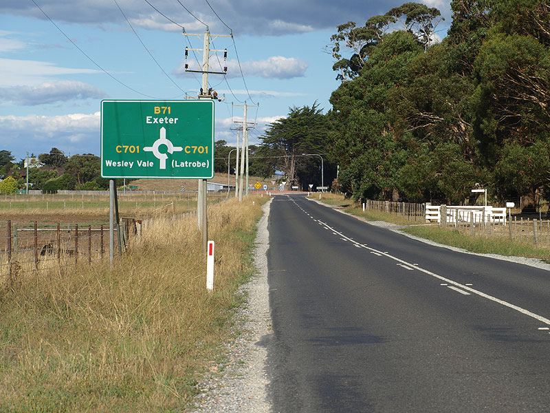
AD sign northbound on Wesley Vale Rd (C701) approaching the intersection with Frankford Main Rd (B71), 2km south of Wesley Vale. The roundabout was constructed in 1999 to address a poor crash history at this intersection. |
 |
ID sign facing southbound traffic at the intersection of Frankford Main Rd (B71) & Wesley Vale Rd (C701). Note the additional poles - this sign was replaced by an identical sign placed on the new poles later in February 2008. |
 |
ID sign facing northbound traffic at the intersection of Frankford Main Rd (B71) & Wesley Vale Rd (C701). This sign was also replaced with an identical sign on new poles in February 2008. Source: Peter Renshaw, February 2008. |
  |
Top: AD sign eastbound on Frankford Main Rd (B71) approaching the intersection with Wesley Vale Rd (C701). Bottom: New AD sign eastbound on Frankford Main Rd (B71) approaching the intersection with Wesley Vale Rd (C701), incorporating additional focal destinations. |
 |
AD sign westbound on Frankford Main Rd (B71), approaching the intersection with Wesley Vale Rd (C701). |
 |
Wesley Vale Rd (C701) looking south towards the intersection with Frankford Main Rd (B71). The curve suggests that this junction once comprised two staggered T-junctions. Source: Peter Renshaw, February 2008. |
 |
Wesley Vale Rd (C701) looking north at Miltons Rd, 300m north of Frankford Main Rd (B71). Source: Peter Renshaw, February 2008. |
 |
Wesley Vale Rd (C701) looking north towards Wesley Vale. The intersection with Port Sorell Main Rd (B74) is located at the top of the first crest - note that this view suggests that the road continues straight, however traffic must turn left, then right to remain on C701. Source: Peter Renshaw, February 2008. |
 |
Wesley Vale Rd (C701) northbound approaching the intersection with Port Sorell Main Rd (B74). Note the dog-leg, as depicted on this old Council-designed AD sign - Westwind Dr was the original route of Mill Rd. Source: Peter Renshaw, February 2008. |
 |
Fingerboard sign pointing traffic south along Wesley Vale Rd (C701) at the intersection with Port Sorell Main Rd (B74) & Westwind Dr. Source: Peter Renshaw, February 2008. |
 |
Fingerboard sign assembly facing northbound traffic at the intersection of Port Sorell Main Rd (B74), Wesley Vale Rd (C701) & Westwind Dr. Westwind Dr can be seen in the background - this was the original route of Mill Rd prior to the dog-leg being created to address a poor crash history. Source: Peter Renshaw, February 2008. |
 |
Port Sorell Main Rd (B74) looking west to the intersection with Mill Rd (C701). This short section of Port Sorell Main Rd between Wesley Vale Rd and Mill Rd carries both the B74 and C701 route codes. Source: Peter Renshaw, February 2008. |
Fingerboard sign facing eastbound traffic at the intersection of Port Sorell Main Rd (B74) & Mill Rd (C701), Wesley Vale. Source: Peter Renshaw, February 2008. |
|
 |
Fingerboard sign assembly facing southbound traffic at the intersection of Port Sorell Main Rd (B74) & Mill Rd (C701), Wesley Vale. Note the absence of a C701 fingerboard directing traffic to the left - the DIER has yet to correct this despite representations from Peter Renshaw. Source: Peter Renshaw, February 2008. |
Port Sorell Main Rd (B74) looking east towards the intersections with Mill Rd (C701) and Wesley Vale Rd (C701) at Wesley Vale. The distances given on this sign assembly suggest the B74/C701 duplex lasts for only approximately 50m. Source: Peter Renshaw, February 2008. |
|
 |
Mill Rd (C701) looking south towards Wesley Vale, showing the curve to the west and Westwind Dr continuing on the straight alignment. Wesley Vale Rd (continuation of C701) can be seen in the disatnce. Source: Peter Renshaw, February 2008. |
 |
Mill Rd (C701) looking east to the ninety-degree bend where Mill Rd changes orientation from north-south to east-west. Source: Peter Renshaw, February 2008. |
 |
Mill Rd (C701) looking east outside the Wesley Vale Paper Mill. Source: Peter Renshaw, February 2008. |
 |
Fingerboard sign assembly at the intersection of Mill Rd (C701), Pardoe Developmental Rd (C701) & Airport Rd at the entrance to Devonport Airport. Source: Peter Renshaw, February 2008. |
 |
Pardoe Developmental Rd (C701) looking east towards the intersection with Airport Rd. C701 continues beyond this intersection as Mill Rd. Source: Peter Renshaw, February 2008. |
|
RD sign on Pardoe Developmental Rd (C701), heading north from the intersection of Port Sorell Main Rd (B74) & Brooke St, 1km south of Devonport Airport. Source: Peter Renshaw, February 2008. |
  |
Top: AD sign southbound on Pardoe Developmental Rd (C701) approaching the intersection with Port Sorell Main Rd (B74) & Brooke St. Bottom: New AD sign which replaced the sign in the above photo. Note the omission of Launceston as a focal destination. |
 |
Port Sorell Main Rd (B74) heading west towards the intersection of Pardoe Developmental Rd (C701) & Brooke St. Source: Peter Renshaw, February 2008. |
 |
ID sign facing northbound traffic at the intersection of Port Sorell Main Rd (B74), Pardoe Developmental Rd (C701) & Brooke St. |
 |
AD sign northbound on Port Sorell Main Rd (B74) with Pardoe Developmental Rd (C701) continuing northwards in the background. Source: Peter Renshaw, February 2008. |
Last updated 3 June 2009 © Ozroads 2004-2009. |