Harford to Hawley Beach |

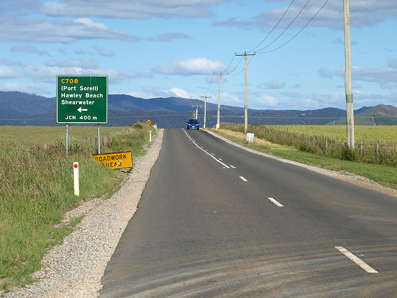
Distance sign heading south on Parkers Ford Rd (C708) from Port Sorell Main Rd (B74). Source: Peter Renshaw, March 2008.
Introduced: 1980
Length: 9km
Northern Terminus: Dumbelton St (C708) & Joyce St, Hawley Beach
Southern Terminus: Frankford Main Rd (B71) & Woodburys Ln (C708), 2km north of Harford
Route taken: Woodburys Ln, Parkers Ford Rd, Anderson St, Dumbleton St
Focal Points: (Narawntapu National Park/Frankford/Exeter), (Port Sorell)/Hawley Beach/Shearwater
Responsibility: Local Government
C708 is an important tourist route in northern Tasmania, running north-south from Frankford Main Rd (B71) to the tourist villages of Squeaking Point, Port Sorell, Shearwater and Hawley Beach. Sealed throughout its 9km length, it is the main access route between the Port Sorell district and the Launceston and West Tamar districts. This important role was reflected in the realignment of Parkers Ford Rd at Squeaking Point Rd (C709) to remove the dog-leg that formerly faced C708 traffic.
|
Photos of route C708 |
|
  |
Top: Frankford Main Rd (B71) eastbound approaching the junction with Woodburys Ln (C708), 2km north of Harford. Note that B71 takes a right turn here to head south to Harford, however the only turn mentioned on the AD sign is for the left turn into C708. Bottom: New AD sign eastbound on Frankford Main Rd (B71) approaching Woodburys Ln (C708), installed in June 2008. Note that the right turn for B71 traffic is still not mentioned. |
 |
Top: AD sign assembly northbound on Frankford Main Rd (B71) approaching Woodburys Ln (C708). This time both C708 and B71 traffic is recognised on the AD sign assembly. Bottom: New diagrammatic AD sign northbound on Frankford Main Rd (B71) approaching Woodburys Ln (C708), installed in June 2008. |
 |
Fingerboard sign assembly facing eastbound traffic at the intersection of Frankford Main Rd (B71) & Woodburys Ln (C708), 2km north of Harford. Source: Peter Renshaw, February 2008. |
| Fingerboard sign facing southbound traffic at the intersection of Frankford Main Rd (B71) & Woodburys Ln (C708), 2km north of Harford. | |
 |
Woodburys Ln (C708) looking south towards the intersection with Frankford Main Rd (B71) where traffic must give way. Source: Peter Renshaw, February 2008. |
 |
Woodburys Ln (C708) looking north, 1km north of Frankford Main Rd (B71). |
 |
Wooden Council signs at the intersection of Woodburys Ln (C708) & Ibbots Rd, 1.5km north of Frankford Main Rd (B71). Note the unusual reference to Frankford Main Rd - declared road names are not usually shown on signs. This sign was removed in September 2008. Source: Peter Renshaw, February 2008. |
 |
Woodburys Ln (C708) looking south, 500m south of Squeaking Point Rd (C709). This section of road is relatively uninteresting. Source: Peter Renshaw, February 2008. |
 |
Woodburys Ln (C708) looking north at the southern intersection with Squeaking Point Rd (C709). Originally, this was a T-junction where C708 traffic had to give way - C708 then turned to the right along a short section of Squeaking Point Rd (C709) before turning left into Parkers Ford Rd (C708). Parkers Ford Rd (C708) has since been realigned to be continuous with Woodburys Ln (C708) - the name change occurs at this intersection. Source: Peter Renshaw, February 2008. |
 |
Fingerboard sign assemblies at the intersection of Woodburys Ln (C708), Parkers Ford Rd (C708/C709) & Squeaking Point Rd (C709). Note that the left-pointing fingerboard has incorrectly omitted reference to C709 and Squeaking Point. |
 |
Parkers Ford Rd looking south along the short C708/C709 duplex between the two junctions with Squeaking Point Rd (C709). This is the small deviation constructed to make C708 continuous and give C709 the dog-leg.
Source: Peter Renshaw, February 2008. |
 |
Fingerboard sign assembly at the intersection of Parkers Ford Rd (C708) & Squeaking Point Rd (C709). Note that the Squeaking Point fingerboards incorrectly omit the C709 route marker, as does the left-pointing C708 fingerboard. |
 |
Parkers Ford Rd (C708) looking south from Manouka Dr, 800m north of Squeaking Point Rd (C709). Source: Peter Renshaw, December 2008. |
 |
Parkers Ford Rd (C708) looking south towards Manouka Dr, 1km north of Squeaking Point Rd (C709). Source: Peter Renshaw, December 2008. |
 |
Parkers Ford Rd (C708) looking north at the small timber bridge across Panatana Rivulet, 1.8km north of Squeaking Point Rd (C709). Source: Peter Renshaw, December 2008. |
Parkers Ford Rd (C708) looking south at Sunhaven Dr, 700m south of Port Sorell Main Rd (B74). |
|
|
Parkers Ford Rd (C708) looking south from the intersection with Port Sorell Main Rd (B74), 2km west of Port Sorell. The placement of a RD sign - which are extremely rare on C routes in Tasmanian - shows the route's importance as a tourist link. Source: Peter Renshaw, March 2008. |
 |
AD sign northbound on Parkers Ford Rd (C708) approaching the intersection with Port Sorell Main Rd (B74). C708 continues straight ahead as Anderson St. Source: Peter Renshaw, December 2008. |
 |
Parkers Ford Rd (C708) looking south at the intersection with Port Sorell Main Rd (B74) & Anderson St (C708). |
AD sign eastbound on Port Sorell Main Rd (B74) approaching the Parkers Ford Rd (C708) & Anderson St (C708) roundabout, 2km west of Port Sorell.
Source: Peter Renshaw, February 2008. |
|
AD sign westbound on Port Sorell Main Rd (B74) approaching the Parkers Ford Rd (C708) & Anderson St (C708) roundabout, 2km west of Port Sorell. Source: Peter Renshaw, February 2008. |
|
| Anderson St (C708) southbound approaching the Port Sorell Main Rd (B74) intersection. | |
 |
Anderson St (C708) looking north from the intersection with Port Sorell Main Rd (B74) into Shearwater - part of the Port Sorell urban area. Source: Peter Renshaw, February 2008. |
 |
Anderson St (C708) looking north to the recently constructed intersection with Club Dr, Shearwater. Note the incorrect focal destination (should be Hawley Beach, not Hawley) and the incorrect omission of C708. Also note that the supplementary services AD is ambiguous as to which direction these are. Source: Peter Renshaw, December 2008. |
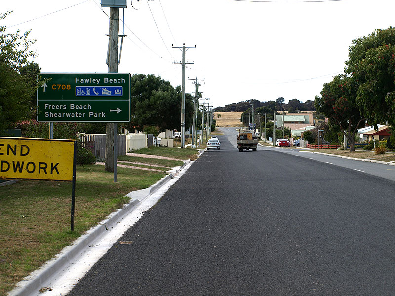 |
Anderson St (C708) looking north to the intersection with Freer St, Shearwater. This AD sign is much better! Source: Peter Renshaw, February 2008. |
 |
Anderson St (C708) looking south into Shearwater from its northern end. |
 |
Looking northeast at the sharp curve where Anderson St (C708) becomes Dumbleton St (C708) - note the locality marker for Hawley Beach. Source: Peter Renshaw, February 2008. |
 |
Dumbleton St (C708) looking east into Hawley Beach. The intersection with Joyce St (where the white car is waiting to turn onto Dumbleton St) is the northern terminus of C708. Source: Peter Renshaw, December 2008. |
 |
A close-up of the Dumbelton St (C708) & Joyce St intersection at Hawley Beach. Heavy vehicles are directed along Joyce St to avoid Hawley Esplanade. Source: Peter Renshaw, December 2008. |


Last updated 30 January 2012 © Ozroads 2003-2012. |