Targa to Upper Blessington |

C405 fingerboard sign with Camden Hill Rd (C405) in the background - looking east at Tasman Highway (A3). Source: Peter Renshaw, April 2007.
Introduced: 1980
Length: 30km
Northern Terminus: Tasman Highway (A3) & Camden Hill Rd (C405), Targa
Southern Terminus: Blessington Main Rd (C401) & Camden Hill Rd (C405), 3km west of Upper Blessington
Route taken: Camden Hill Rd, Camden Rd
Focal Points: None
Responsibility: Local Government
C405 is a 30km long, mostly unsealed north-south route linking the Tasman Highway (A3) near Targa with Blessington Main Rd (C401) near Ben Lomond. It provides a direct route from Scottsdale and north-eastern Tasmania to the North Esk River valley and the mountain resort of Ben Lomond. Despite this, DIER has not seen fit to provide any focal destinations on C405 signs.
|
Photos of route C405 |
|
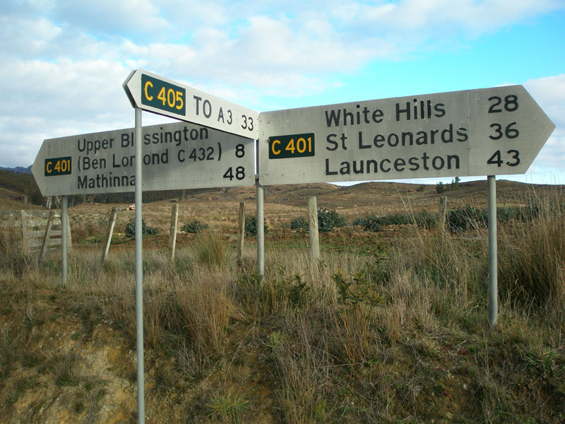 |
Fingerboard sign assembly at the intersection of Blessington Main Rd (C401) & Camden Rd (C405) at Wattle Corner, 3km west of Upper Blessington. Note the absence of a focal destination - not even Targa was considered worthy of signposting. |
 |
Camden Rd (C405) looking north to the timber bridge over North Esk River at Wattle Corner, 250m north of Wattle Corner. Source: Peter Renshaw, June 2007. |
 |
Camden Rd (C405) looking south to the timber bridge over North Esk River at Wattle Corner, 500m north of Wattle Corner. |
 |
Camden Rd (C405) looking south at the end of the sealed surface, 750m north of Wattle Corner. |
 |
Camden Rd (C405) follows the valley of the North Esk River - this view is looking northwards at Long Acre Marsh, 2.5km north of Wattle Corner. Source: Peter Renshaw, June 2007. |
 |
Camden Rd (C405) looking south at Long Acre Marsh with Ben Lomond as a backdrop, 4km north of Wattle Corner. Source: Peter Renshaw, June 2007. |
 |
Camden Rd (C405) looking south alongside the North Esk River, 5km north of Wattle Corner. Camden Hill Rd transitions from farmland to forest here. |
 |
Apocalyptic view of a recently logged section of forest at Camden Creek, 9km north of Wattle Corner. |
 |
Recently realigned section of Camden Rd, looking north at Peddles Creek, 18km north of Wattle Corner. Source: Peter Renshaw, June 2007. |
 |
Camden Rd (C405) looking north to a short section of sealed surface at Tayene. |
 |
Camden Rd (C405) looking south along the sealed section of road, north of Tayene. Source: Peter Renshaw, June 2007. |
 |
Camden Rd (C405) looking south, 2.5km north of Tayene. Camden Rd curves around the back of Mt Barrow, which forms an impressive backdrop. Source: Peter Renshaw, June 2007. |
 |
Camden Rd (C405) looking north to the oblique intersection with Diddleum Rd, 7km east of Tasman Highway (A3). Diddleum Rd is the never-signed extension of C406, which leads to C406 at South Springfield. Source: Peter Renshaw, June 2007. |
 |
Council signage at the intersection of Camden Rd (C405), Camden Hill Rd (C405) & Diddluem Rd. No C405 or C406 signage at this intersection. Camden Rd becomes Camden Hill Rd for the journey to Tasman Highway. Source: Peter Renshaw, June 2007. |
 |
Camden Hill Rd (C405) looking west through forested country between Diddluem Rd and Tasman Highway (A3). Source: Peter Renshaw, June 2007. |
 |
Camden Hill Rd (C405) becomes sealed approximately 2km west of Tasman Highway (A3). This view is looking east near the end of the seal, with Seven Time Creek on the left. Source: Peter Renshaw, June 2007. |
 |
Camden Hill Rd (C405) looking west near Priors Rd, 500m east of Tasman Highway (A3). Source: Peter Renshaw, June 2007. |
|
The lone C405 fingerboard sign at the intersection of Tasman Highway (A3) & Camden Hill Rd (C405) at Targa, with Camden Hill Rd (C405) in the background.
Source: Peter Renshaw, April 2007. |
 |
The A3 fingerboard signs at the intersection of Tasman Highway (A3) & Camden Hill Rd (C405), Targa. Source: Peter Renshaw, July 2007. |
Last updated 7 June 2009 © Ozroads 2004-2009. |