Scottsdale to Waterhouse |

Fingerboard sign at the junction of North Scottsdale Rd (C831/C832) & Old Waterhouse Rd (C832), 5km northeast of Scottsdale. Source: Peter Renshaw, April 2008.
Introduced: 1980
Length: 33km
Northern Terminus: Waterhouse Rd (B82) & Old Waterhouse Rd (C832), 3km west of Waterhouse
Southern Terminus: Bridport Main Rd (B82) & Cameron St (C832) & Ellenor St, Scottsdale
Route taken: Cameron St, North Scottsdale Rd, Old Waterhouse Rd
Focal Points: Scottsdale, (North Scottsdale)
Responsibility: Local Government
C832 is a mostly unsealed route in rural north eastern Tasmania, running north-east from Scottsdale towards the seaside villages on Bass Strait. The name 'Old Waterhouse Road' indicates that it was once the main route to this area of the north-east coast, however most traffic now follows the sealed route via Bridport.
Commencing in Scottsdale, C832 runs northeast through fertile agricultural land as a narrow, but sealed, road towards North Scottsdale. Leaving the farmland for the forest, C832 loses its sealed pavement, turns north and becomes a rather sandy unsealed route through state forests.
A short unsigned duplex with C831 is located along an approximately 30m long section of North Scottsdale Rd, 5km east of Scottsdale.
|
Photos of route C832 |
|
 |
B84 fingerboard sign assembly facing C832 traffic at the junction of Bridport Main Rd (B84), Cameron St (C832) & Ellenor St, Scottsdale. |
 |
C832 fingerboard sign assembly at the junction of Bridport Main Rd (B84), Cameron St (C832) & Ellenor St, Scottsdale. Note the difference in age (and reflectivity) between the North Scottsdale sign and the hospital sign. |
 |
Fingerboard sign assemblies at the junction of Bridport Main Rd (B84), Cameron St (C832) & Ellenor St, Scottsdale. Note that the fingerboard sign facing Ellenor St refers to A3, rather than B84 (which terminates at A3 at the next intersection). |
 |
Cameron St (C832) looking west towards the junction with Bridport Main Rd (B84) at Scottsdale. |
 |
North Scottsdale Rd (C832) looking east from the junction with Fosters Rd near the hospital. Cameron St becomes North Scottsdale Rd at this junction. Source: Peter Renshaw, November 2007. |
 |
North Scottsdale Rd (C832) looking east towards the bridge over Tuckers Creek, 1.5km east of Scottsdale. Source: Peter Renshaw, November 2007. |
| North Scottsdale Rd (C832) looking west across Tuckers Creek. | |
 |
North Scottsdale Rd (C832) looking west as it curves up the hill towards Williams Rd, 2.5km east of Scottsdale. Source: Peter Renshaw, November 2007. |
 |
North Scottsdale Rd (C832) looking east towards the junction with Jensens Rd (C831) - just beyond the white fence - 4km east of Scottsdale. Source: Peter Renshaw, November 2007. |
 |
Fingerboard sign assembly at the junction of North Scottsdale Rd (C831/C832) & Jensens Rd (C831), 5km east of Scottsdale. Note the absence of a C831 fingerboard pointing to the right. Source: Peter Renshaw, October 2007. |
 |
Fingerboard signs at the junction of North Scottsdale Rd (C831/C832) & Old Waterhouse Rd (C832), just beyond the previous junction. Note the absence of a C832 fingerboard pointing to the left in the top photo. C832 shifts from North Scottsdale Rd to Old Waterhouse Rd at this junction. Top photo : Peter Renshaw, April 2008. Bottom photo: Peter Renshaw, October 2007. |
 |
Old Waterhouse Rd (C832) looking west to the junction with North Scottsdale Rd (C831), with North Scottsdale Rd continuing in the distance. Source: Peter Renshaw, November 2007. |
 |
Old Waterhouse Rd (C832) looking east at the end of the sealed surface just before Monazite Creek, 6.5km east of Scottsdale. Source: Peter Renshaw, November 2007. |
 |
Beyond the end of the sealed pavement, Old Waterhouse Rd (C832) turns to the north and becomes a sandy, unsealed route running through forested areas. This view shows the sandy surface looking south, 9km northeast of Scottsdale. Source: Peter Renshaw, November 2007. |
 |
Old Waterhouse Rd (C832) looking north to the junction with Forester Rd (C834), 11km northeast of Scottsdale. Forester Rd (C834) runs east through the state forests towards Branxholm and Winnaleah. Source: Peter Renshaw, November 2007. |
 |
Fingerboard sign assembly at the junction of Old Waterhouse Rd (C832) & Forester Rd (C834). Note the illogical placement of the C832 fingerboard signs - not facing C834 traffic. Source: Peter Renshaw, November 2007. |
 |
Old Waterhouse Rd (C832) looking south towards the junction with Forester Rd (C834), 11km northeast of Scottsdale.
Source: Peter Renshaw, December 2007. |
 |
Old Waterhouse Rd (C832) looking north approximately 500m north of the junction with Forester Rd (C834), showing a recently graded section. Source: Peter Renshaw, December 2007. |
 |
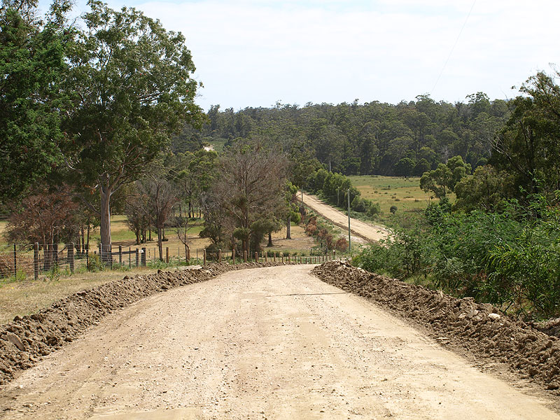
Old Waterhouse Rd (C832) looking south across Surveyors Creek, 12.5km northeast of Scottsdale. The roadworks signage refers to the recent road grading. Source: Peter Renshaw, December 2007. |
 |
Old Waterhouse Rd (C832) looking south, 13.5km northeast of Scottsdale.
Source: Peter Renshaw, December 2007. |
 |
Old Waterhouse Rd (C832) looking north at the completly unsignposted junction with Boat Hole Rd, 15.5km northeast of Scottsdale. C832 goes off to the right. Source: Peter Renshaw, December 2007. |
 |
Old Waterhouse Rd (C832) looking north across Wonder Valley towards the crossing of the Great Forester River, 16.5km northeast of Scottsdale. Source: Peter Renshaw, December 2007. |
 |
Old Waterhouse Rd (C832) looking south at the timber bridge over Great Forester River, 17.5km northeast of Scottsdale. Source: Peter Renshaw, December 2007. |
 |
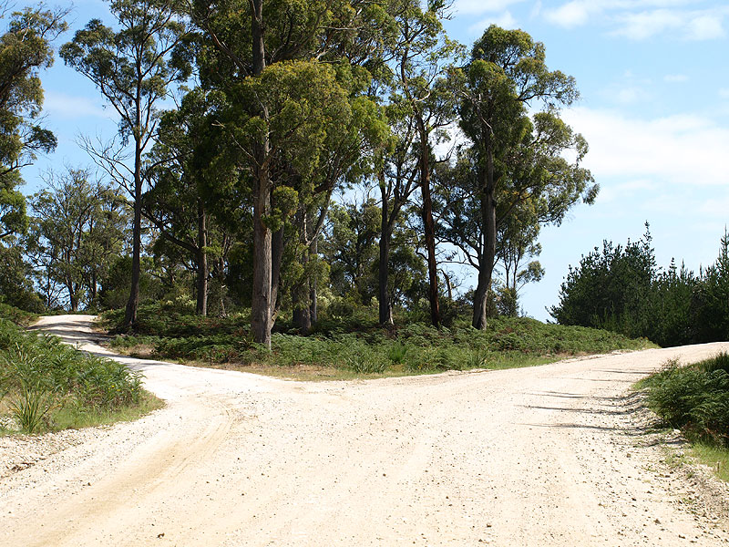
Old Waterhouse Rd (C832) looking north towards the triangular junction with Williams Hill Rd, 19km northeast of Scottsdale. Source: Peter Renshaw, December 2007. |
 |
This old-style fingerboard sign assembly is at the western leg of the triangular junction with Williams Hill Rd. This type of sign was prevalent across Tasmania before alpha-numeric route marking was introduced in the 1980s. Source: Peter Renshaw, December 2007. |
 |
Fingerboard sign assembly located at the eastern leg of the triangular junction with Williams Hill Rd. Note that these signs don't actually face Williams Rd - they are only visible to through traffic on C832. Source: Peter Renshaw, December 2007. |
 |
Old Waterhouse Rd (C832) looking south to the junction with Williams Hill Rd, 19km northeast of Scottsdale. Old Waterhourse Rd curves to the right in the dip - the junction at the top of the crest is the apex of the triangular junction. Source: Peter Renshaw, December 2007. |
 |
Old Waterhouse Rd (C832) looking north at Oxberry Rd, 20km northeast of Scottsdale. Oxberry Rd was to be marked as C833 under early plans for alpha-numeric route marking in Tasmania, however this never eventuated. Source: Peter Renshaw, December 2007. |
 |
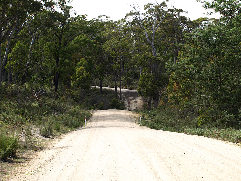
Old Waterhouse Rd (C832) looking south towards Oxberry Creek, 23km northeast of Scottsdale. |
 |
Old Waterhouse Rd (C832) looking south near Halfway Rd, 27km northeast of Scottsdale. Source: Peter Renshaw, December 2007. |
 |
Unusual timber sight board facing Halfway Rd traffic at the junction with Old Waterhouse Rd (C832), 27.5km northeast of Scottsdale. Source: Peter Renshaw, December 2007. |
 |
Old Waterhouse Rd (C832) looking north, 2.5km south of Waterhouse Rd (B82), across the coastal plain with sand dunes in the distance. |
 |
A westerly view of the junction of Waterhouse Rd (B82) & Old Waterhouse Rd (C832), 3km west of Waterhouse. Source: Peter Renshaw, October 2007. |
 |
Fingerboard sign assembly at the junction of Waterhouse Rd (B82) & Old Waterhouse Rd (C832). There are no AD signs on approach to this junction. Source: Peter Renshaw, October 2007. |

Last updated 23 June 2009 © Ozroads 2004-2009. |