Pipers River to Lebrina |

Fingerboard sign assembly at the intersection of Bridport Main Rd (B82) & Retreat Rd (C819), 25km southwest of Bridport. Source: Peter Renshaw, October 2007.
Introduced: 1980
Length: 16km
Northern Terminus: Bridport Main Rd (B82) & Retreat Rd (C819), 25km southwest of Bridport
Southern Terminus: Golconda Rd (B81) & Hextalls Rd (C819), Lebrina
Route taken: Hextalls Rd, Yondover Rd, Retreat Rd
Focal Points: Retreat, Lebrina
Responsibility: Local Government
C819 is a mostly unsealed north-south route in northern Tasmania. It runs through agricultural and forestry lands and serves the once-important hamlet of Retreat. It is of lower standard with no major tourist attraction and is consequently of lesser important than its eastern twin, C818 (Pipers Brook Rd).
|
Photos of route C819 |
|
 |
Fingerboard sign assembly at the intersection of Golconda Rd (B81) & Hextalls Rd (C819), Lebrina. Source: Peter Renshaw, April 2007. |
 |
Hextalls Rd (C819) looking east towards the junction with Golconda Rd (B81) at Lebrina. Source: Peter Renshaw, October 2007. |
 |
Hextalls Rd (C819) looking west approximately 500m west of Golconda Rd (B81). The first 1km of this route is straight with a short unsealed section, followed by a couple of sharp bends zig-zagging to the north which follow long-established property lines. Source: Peter Renshaw, October 2007. |
 |
Hextalls Rd (C819) looking south-east across the zig zags, 1.3km west of Lebrina. Source: Peter Renshaw, October 2007. |
 |
Hextalls Rd (C819) looking east near Lockharts Rd, 1.7km west of Lebrina. Source: Peter Renshaw, October 2007. |
Hextalls Rd (C819) looking west at the transition from farmland to forest, 2.2km west of Lebrina. Source: Peter Renshaw, October 2007. |
|
 |
Hextalls Rd (C819) looking east through the forestry area, 3.5km west of Lebrina. In this vicinity, Hextalls Rd becomes Yondover Rd. Source: Peter Renshaw, October 2007. |
 |
Yondover Rd (C819) looking northwest through the forestry area, 4.5km west of Lebrina. Source: Peter Renshaw, October 2007. |
 |
Yondover Rd (C819) looking northwest towards the intersection with Retreat Rd, which is located at the bottom of this slope, 5.5km west of Lebrina. Source: Peter Renshaw, October 2007. |
 |
Yondover Rd (C819) looking north at the intersection with Retreat Rd. C819 continues north as Retreat Rd. Retreat Rd also continues south to meet Tunnel Rd (C820) at Tunnel. Note the fingerboard sign assembly that doesn't face the side-road, something that is not that unusual in north-eastern Tasmania. Source: Peter Renshaw, October 2007. |
 |
Close-up of the fingerboard sign assembly with Retreat Rd in the background at the intersection with Yondover Rd (C819), 6km west of Lebrina. Source: Peter Renshaw, October 2007. |
 |
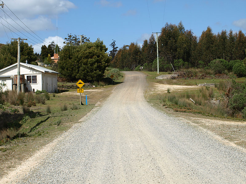
Retreat Rd (C819) looking north at the tiny hamlet of Retreat. The concrete on the left is the remains of a shop and service station, closed by the 1960s, perhaps indicating that Retreat Road once carried a more traffic than it presently does. Source: Peter Renshaw, October 2007. |
 |
Retreat Rd (C819) looking south through Retreat. The speed hump on the northern approach is used to slow traffic, particularly log trucks. Source: Peter Renshaw, October 2007. |
 |
Retreat Rd (C819) looking north at Kettles Rd on the northern outskirts of Retreat. Source: Peter Renshaw, October 2007. |
 |
Retreat Rd (C819) looking south at the intersection with South Retreat Rd (straight ahead), 1.6km north of Retreat. There is a need for proper C819 fingerboard signs to indicate the left turn. Source: Peter Renshaw, October 2007. |
Retreat Rd (C819) looking north older forest, 4km north of Retreat. Source: Peter Renshaw, October 2007. |
|
 |
Forestry signage dating from the 1970s on Retreat Rd, 5km north of Retreat. Source: Peter Renshaw, October 2007. |
 |
Retreat Rd (C819) looking south, 2km south of Bridport Main Rd (B82). Source: Peter Renshaw, October 2007. |
 |
Retreat Rd (C819) looking north towards the intersections with Hall Rd and Bridport Main Rd (B82). Source: Peter Renshaw, October 2007. |
 |
Fingerboard sign assembly at the intersection of Retreat Rd (C819) & Hall Rd, only a matter of metres south of Bridport Main Rd (B82). The left-pointing fingerboard incorrectly points down Hall Rd instead of towards Bridport Main Rd (B82). Source: Peter Renshaw, October 2007. |
 |
Retreat Rd (C819) looking south from Bridport Main Rd (B82) towards Hall Rd. Source: Peter Renshaw, October 2007. |
Fingerboard sign assembly at the intersection of Bridport Main Rd (B82) & Retreat Rd (C819), 7km east of Pipers River. |
|
 |
AD sign westbound on Bridport Main Rd (B82) approaching Retreat Rd (C819), 7km east of Pipers River. Source: Peter Renshaw, September 2007. |
 |
AD sign eastbound on Bridport Main Rd (B82) approaching Retreat Rd (C819), 7km east of Pipers River. Source: Peter Renshaw, September 2007. |

Last updated 31 May 2009 © Ozroads 2004-2007. |