Banca Road |
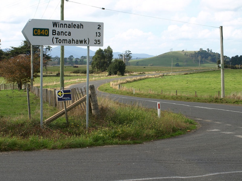
Fingerboard sign at the intersection of Tasman Hwy (A3) & Winnaleah Rd (C840), 2km south of Winnaleah. Source: Peter Renshaw, January 2008.
Introduced: 1980
Length: 24km
Northern Terminus: Waterhouse Rd (B82) & Banca Rd (C840), 20km west of Gladstone
Southern Terminus: Tasman Hwy (A3) & Winnaleah Rd (C840), 2km south of Winnaleah
Route taken: Winnaleah Rd, Banca Rd
Focal Points: 'To A3', Winnaleah, Banca, (Tomahawk)
Responsibility: Local Government
C840 is a 24km long north-south route in north eastern Tasmania. The southern portion of the route provides an important link between Tasman Hwy (A3) and the small village of Winnaleah. The northern portion of the route is of much lesser importance, providing a route for Derby, Branxholm and Winnaleah area traffic to reach the northern coast between Bridport and Gladstone.
The route is sealed for the southern-most 9km, with the remaining 15km unsealed albeit in good condition when these photos were taken.
|
Photos of route C840 |
|
 |
Fingerboard sign assembly at the intersection of Waterhouse Rd (B82) & Banca Rd (C840), 20km west of Gladstone. |
 |
Banca Rd (C840) looking north towards the junction with Waterhouse Rd (B82) at the northern terminus of the route. |
 |
Banca Rd (C840) looking south towards Mt Horror, 200m south of Waterhouse Rd (B82). |
 |
Banca Rd (C840) looking south across the Boobyalla River flats, 500m south of Waterhouse Rd (B82). |
 |
Banca Rd (C840) looking north at Brooks Creek, 5km south of Waterhouse Rd (B82). Source: Peter Renshaw, January 2008. |
 |
Banca Rd (C840) looking south through the state forest, 8km south of Waterhouse Rd (C840). The sign reads 'Banca No 7' and refers to a specific plantation area. Source: Peter Renshaw, January 2008. |
| Banca Rd (C840) looking south towards the intersection with Oxberry Rd, located at the top of the next rise. Oxberry Rd was originally allocated route C833 but was never signed. |
|
 |
Banca Rd (C840) looking south across Banca Creek, immediately south of Oxberry Rd, 11km south of Waterhouse Rd (B82). Source: Peter Renshaw, January 2008. |
 |
Banca Rd (C840) looking southeast towards the bridge over Boobyalla River. Note the changing landscape as you emerge from the forests into the dairying country approaching Winnaleah. Source: Peter Renshaw, January 2008. |
 |
Banca Rd (C840) looking south towards Martins Rd, showing the changing landscape, 15km south of Waterhouse Rd (B82). Source: Peter Renshaw, January 2008. |
 |
Banca Rd (C840) looking north, showing the transition from sealed to unsealed pavement, 15km south of Waterhouse Rd (B82). Source: Peter Renshaw, January 2008. |
 |
Banca Rd (C840) looking north towards Mt Horror near Johnstons Rd, 17km south of Waterhouse Rd (B82). Source: Peter Renshaw, January 2008. |
 |
Banca Rd (C840) looking south towards the junction with Banca Link (C839), 18km south of Waterhouse Rd (B82). Source: Peter Renshaw, January 2008. |
Fingerboard signs at the intersection of Banca Rd (C840) & Banca Link (C839), 18km south of Waterhouse Rd (B82) and 4km north of Winnaleah. There is no fingerboard sign pointing towards the south. Source: Peter Renshaw, January 2008. |
|
 |
Banca Rd (C840) looking south near Trout Creek, 3km north of Winnaleah. Source: Peter Renshaw, January 2008. |
 |
Banca Rd (C840) looking south through the Trout Creek valley, 2km north of Winnaleah. Source: Peter Renshaw, January 2008. |
 |
Banca Rd (C840) looking south to the junction with Racecourse Rd, 1km north of Winnaleah. Racecourse Rd is a short cut between Winnaleah and C839, leading to Pioneer. Source: Peter Renshaw, January 2008. |
Recently replaced fingerboard signs at the intersection of Banca Rd (C840) & Racecourse Rd, 1km north of Winnaleah. Source: Peter Renshaw, January 2008. |
|
 |
Banca Rd (C840) looking north towards the junction with Racecourse Rd. Banca Rd turns left here. Source: Peter Renshaw, January 2008. |
 |
Banca Rd (C840) looking south into the town of Winnaleah. Source: Peter Renshaw, January 2008. |
 |
Fingerboard signs at the intersection of Winnaleah Rd (C840) & Main St (C835), Winnaleah. Source: Peter Renshaw, January 2008. |
 |
Winnaleah Rd (C840) looking south through the southern side of Winnaleah. Source: Peter Renshaw, January 2008. |
 |
Winnaleah Rd (C840) looking south, approaching a sharp bend and dip at Davids Creek, midway between Winnaleah and Tasman Hwy (A3). Source: Peter Renshaw, January 2008. |
 |
Winnaleah Rd (C840) looking east approaching the southern terminus of the route at the junction with Tasman Hwy (A3), 2km south of Winnaleah. Source: Peter Renshaw, January 2008. |
  |
Old and new fingerboard signs at the intersection of Tasman Hwy (A3) & Winnaleah Rd (C840), 2km south of Winnaleah. Top photo: Peter Renshaw, January 2008. Bottom photo: Peter Renshaw, April 2009. |
  |
Old and new fingerboard signs at the intersection of Tasman Hwy (A3) & Winnaleah Rd (C840), 2km south of Winnaleah. Top photo: Peter Renshaw, January 2008. Bottom photo: Peter Renshaw, April 2009. |
  |
Old and new AD signs eastbound on Tasman Hwy (A3) approaching Winnaleah Rd (C840), 2km south of Winnaleah. Top photo: Peter Renshaw, February 2008. Bottom photo: Peter Renshaw, April 2009. |
  |
Old and new AD signs eastbound on Tasman Hwy (A3) approaching Winnaleah Rd (C840), 2km south of Winnaleah. Top photo: Peter Renshaw, February 2008. Bottom photo: Peter Renshaw, December 2010. |


Last updated 15 May 2011 © Ozroads 2004-2011. |