Lymington to Wattle Grove |
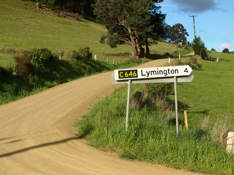
Fingerboard sign at the junction of Forsters Rivulet Road (C646) & Jetty Road, 4km west of Lymington. Source: Peter Renshaw, November 2008.
Introduced: 1980
Length: 5.5km
Eastern Terminus: Lymington Rd (C839) & Forsters Rivulet Rd (C846), Lymington
Western Terminus: Wattle Grove Rd (C840), Forsters Rivulet Rd (C846) & Sunday Hill Rd, 2km E of Wattle Grove
Route taken: Forsters Rivulet Rd
Focal Points: (Wattle Grove), Lymington
Responsibility: Local Government
C846 is a minor rural route in southern Tasmania's Huon Valley. It commences at Lymington, on the shores of Port Cygnet, and ascends the watershed separating Port Cygnet and the Huon River, following the course of Forsters Rivulet. At its western end, C846 connects to C840, which completes the journey to the eastern shore of the Huon River.
The route is sealed for approximately 2.5km westerly from Lymington and the remainder towards Wattle Grove is unsealed.
|
Photos of route C646 |
|
  |
Fingerboard signs at the intersection of Wattle Grove Road (C640), Forsters Rivulet Road (C646) & Sunday Hill Road, 2km east of Wattle Grove. |
Two shots of a positively ancient fingerboard sign at the intersection of Wattle Grove Road (C640), Forsters Rivulet Road (C646) & Sunday Hill Road, 2km east of Wattle Grove. This sign appears to date from the days of imperial measurements - the 4.8 kilometre distance probably covers 3 miles. |
|
 |
View east along the start of Forsters Rivulet Road (C646) from the junction with Wattle Grove Road (C640). |
Forsters Rivulet Road (C646) looking east towards the junction with Jetty Road. Forsters Rivulet Road and route C646 turn right here, whilst Jetty Road continues, unnumbered, towards Cygnet. Source: Peter Renshaw, November 2008. |
|
  |
Fairly recent fingerboard signs at the junction of Forsters Rivulet Road (C646) & Jetty Road, 4km east of Wattle Grove. Note how the right-pointing fingerboard incorrectly shows C646 towards Cygnet - Jetty Road is actually unnumbered. Also note the absence of a distance for Wattle Grove. Source: Peter Renshaw, November 2008. |
Forsters Rivulet Road (C646) looking south from the junction with Jetty Road. |
|
 |
Forsters Rivulet Road (C646) looking east towards Guddens Road on the outskirts of Lymington. Source: Peter Renshaw, November 2008. |
 |
Forsters Rivulet Road (C646) looking west from Lymington. Source: Peter Renshaw, November 2008. |
 |
Town entry sign eastbound on Forsters Rivulet Road (C646) as you approach the junction with Lymington Road (C639) at Lymington. Note the glimpse of a cold-looking Port Cygnet. Source: Peter Renshaw, November 2008. |
  |
Fingerboard signs at the junction of Lymington Road (C639) & Forsters Rivulet Road (C646), Lymington. This is the eastern terminus of C646. Source: Peter Renshaw, November 2008. |
 |
Looking south along Lymington Road (C639) towards the junction with Forsters Rivulet Road (C646), Lymington. Source: Peter Renshaw, November 2008. |

Last updated 5 August 2012. © Ozroads 2003-2012. |