Thirlstane to Squeaking Point |

Fingerboard sign assemblies at the intersection of Woodburys Ln (C708), Parkers Ford Rd (C708) & Squeaking Point Rd (C709). Source: Peter Renshaw, February 2008.
Introduced: 1980
Length: 6km
Eastern Terminus: Squeaking Point Rd (C709) & Esplanade, Squeaking Point
Western Terminus: Frankford Main Rd (B71) & Squeaking Point Rd (C709), Thirlstane
Route taken: Squeaking Point Rd (with a short section on Parkers Ford Rd between the two sections of Squeaking Point Rd)
Focal Points: Thirlstane, Squeaking Point
Responsibility: Local Government
C709 is a short rural connector in northern Tasmania, linking Frankford Main Rd (B71) - and thus Latrobe and Devonport - with the holiday village of Squeaking Point. Sealed throughout its length, it is of a reasonable vertical and horizontal realignment. It contains a short duplex with C708 between two staggered T-junctions.
The staggered T-junctions with C708 (Parkers Ford Rd/Woodburys Ln), 2km west of Squeaking Point, have been realigned to give C708 traffic priority. Previously, Squeaking Point Rd was continuous and C708 traffic faced a dog-leg situation.
Currently, C709 is not signed along the short duplex with C708 or on the eastern section of Squeaking Point Rd. This matter has been raised with Latrobe Council and Ozroads is awaiting a response.
|
Photos of route C709 |
|
   |
Top: Frankford Main Rd (B71) eastbound approaching the junction with Squeaking Point Rd (C709) at Thirlstane. Middle: New and old AD signs in situ at the same time, eastbound on Frankford Main Rd (B71) approaching Squeaking Point Rd (C709), Thirlstane. Bottom: New AD sign eastbound on Frankford Main Rd (B71) approaching Squeaking Point Rd (C709) with the old sign since removed. |
| Frankford Main Rd (B71) westbound approaching the junction with Squeaking Point Rd (C709), Thirlstane. | |
  |
Top: Fingerboard sign facing eastbound traffic at the intersection of Frankford Main Rd (B71) & Squeaking Point Rd (C709), Thirlstane. Bottom: Renewed fingerboard sign facing eastbound traffic at the intersection of Frankford Main Rd (B71) & Squeaking Point Rd (C709), installed in February 2008. |
| Top: Fingerboard sign assembly facing C709 traffic at the intersection of Frankford Main Rd (B71) & Squeaking Point Rd (C709), Thirlstane. Bottom: Renewed fingerboard sign assembly facing C709 traffic at the intersection of Frankford Main Rd (B71) & Squeaking Point Rd (C709), installed in February 2008. | |
 |
Squeaking Point Rd (C709) looking east from Frankford Main Rd (B71) with a sign informing motorists of the temporary closure of Parkers Ford Rd (C708) bridge over Panatana Rivulet. Source: Peter Renshaw, December 2008. |
 |
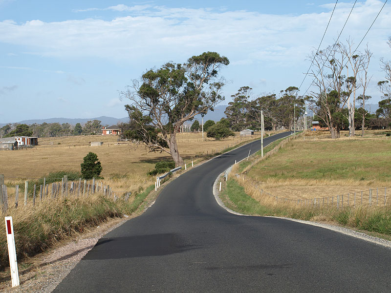
Squeaking Point Rd (C709) looking east, 500m east of Frankford Main Rd (B71). The Applebys Rd (C707) intersection is at the top of the small rise in the distance. Source: Peter Renshaw, January 2009. |
  |
Top: Deteriorating - and bordering on illegiable - fingerboard signs at the intersection of Squeaking Point Rd (C709) & Applebys Rd (C707), 1km east of Thirlstane. Bottom: Following representations from Peter Renshaw, Latrobe Council renewed the route markers on these fingerboards in July 2008 to make them legible again. |
 |
Squeaking Point Rd (C709) looking east across Panatana Rivulet, 500m east of Applebys Rd (C707). |
 |
Squeaking Point Rd (C709) looking east to the Ibbotts Rd intersection, located on the bend ahead. Note the dodgy curve arrow on the warning sign.
Source: Peter Renshaw, February 2008. |
 |
Fingerboard signs at the intersection of Squeaking Point Rd (C709) & Ibbotts Rd, 1km east of Applebys Rd (C707). Ibbotts Rd leads east to Woodburys Ln (C708), whilst Squeaking Point Rd (C709) turns north-east towards Squeaking Point. Source: Peter Renshaw, February 2008. |
 |
Squeaking Point Rd (C709) looking south-west towards the intersection with Ibbotts Rd. Source: Peter Renshaw, February 2008. |
Squeaking Point Rd (C709) looking north-east to the intersection with Woodburys Ln (C708) & Parkers Ford Rd (C708). Note that Squeaking Point Rd formerly continued straight, with C708 traffic facing two staggered T-junctions. |
|
|
Fingerboard sign assemblies at the intersection of Woodburys Ln (C708), Parkers Ford Rd (C708) & Squeaking Point Rd (C709). Note that C709 continues left, however the left-pointing C708 fingerboard incorrectly omits all reference to C709 and Squeaking Point. This sign is actually the eastern-most C709 sign. Source: Peter Renshaw, February 2008. |
 |
Parkers Ford Rd (C708/C709) looking south along the short C708/C709 duplex between the two sections of Squeaking Point Rd. This section is the small deviation which was constructed to remove the dog-leg which faced C708 traffic. Source: Peter Renshaw, February 2008. |
 |
Fingerboard sign assembly at the intersection of Parkers Ford Rd (C708) & Squeaking Point Rd (C709). Note that the Squeaking Point and left-pointing C708 fingerboard signs incorrectly omit the C709 route marker. Source: Peter Renshaw, February 2008. |
 |
Squeaking Point Rd (C709) looking east from the intersection with Parkers Ford Rd (C708). This section of Squeaking Point Rd was formerly part of Parkers Ford Rd prior to the construction of the deviation. Source: Peter Renshaw, February 2008. |
Squeaking Point Rd (C709) looking east approximately 1km east of Parkers Ford Rd (C708). These houses form part of the hamlet of Squeaking Point.
Source: Peter Renshaw, February 2008. |
|
 |
Squeaking Point Rd (C709) looking east at Squeaking Point with the end of the road imminent. Source: Peter Renshaw, February 2008. |
| Squeaking Point Rd (C709) looking east at its eastern terminus. To the left is Esplanade, and to the right is the entrance to Squeaking Point Caravan Park. | |


Last updated 9 February 2009 © Ozroads 2004-2009. |