Launceston to Mathinna |

Blessington Main Rd (C401) looking west from Musselboro Rd (C415), with Ben Lomond forming an imposing backdrop. Source: Peter Renshaw, July 2007.
Introduced: 1980
Length: 87km
Eastern Terminus: Mathinna Rd (B43) & Upper Esk Rd (C401) & Mathinna Plains Rd (C423) & Smith St (C429), Mathinna
Western Terminus: Tasman Highway (A3) & Blessington Main Rd (C401), Waverley
Route taken: Blessington Main Road, Upper Blessington Road, Telopea Road, Gunns Road, Upper Esk Road
Focal Points: Launceston, St Leonards, White Hills, (Ben Lomond), Upper Blessington, Mathinna
Responsibility: State Government (Blessington Main Road) Local Government (Upper Blessington Road, Telopea Road, Gunns Road & Upper Esk Road)
C401 is an east-west route in northern Tasmania, linking Launceston with the fertile North Esk Valley and the popular Ben Lomond National Park, as well as providing a low standard route across the mountain ranges between the midlands and the east coast.
C401 begins at Waverley, 4km east of Launceston CBD, and heads south through the Launceston suburb of St Leonards before entering the rolling fields along the North Esk River valley. Turning east near White Hills, the countryside becomes more heavily wooded before clearing out again in the Blessington area. At Upper Blessington the Main Road ends, and the sealed pavements ends a few kilometres later. C401 then heads into the mountainous country, crossing Roses Tier on a route susceptible to ice and snow in the colder months, before descending into the South Esk River valley towards Mathinna.
A long section of the route, from Waverley to Upper Blessington, is classified as a Main Road and maintained by the DIER, whilst lengthy sections between Upper Blessington and Upper Esk are logging routes maintained by Forestry Tasmania. The remainder of the route is under the care and control of the relevant Council.
Between Waverley and the southern boundary of St Leonards, the 'local' name of the route is St Leonards Road. This name is preferred on direction signs, however the captions below refer to the declared name of the route under the Roads and Jetties Act 1935 - i.e. Blessington Main Road.
C401 is the signposted route from Launceston to Ben Lomond - a popular mountain resort and National Park - and the majestic mountain provides an imposing and attractive backdrop to many parts of the route.
|
Photos of route C401 |
|
 |
Top: AD sign southbound on Tasman Highway (A3) approaching the junction with Blessington Main Road (C401) at Waverley. Bottom: New AD sign southbound on Tasman Highway (A3) approaching the junction with Blessington Main Rd (C401) at Waverley. St Leonards Road is the 'local' name for Blessington Main Road between Waverley and St Leonards and is preferred on direction signs. |
 |
AD sign westbound on Tasman Highway (A3) approaching the junction with Blessington Main Rd (C401) at Waverley. Source: Peter Renshaw, May 2008. |
  |
Top: C401 ID sign at the intersection of Tasman Highway (A3) & Blessington Main Rd (C401), Waverley. Bottom: New C401 ID sign at the intersection of Tasman Highway (A3) & Blessington Main Rd (C401), Waverley. |
  |
Top: AD sign northbound on Blessington Main Rd (C401), approaching the intersection with Tasman Highway (A3) at Waverley. Bottom: New AD sign northbound on Blessington Main Rd (C401), approaching the intersection with Tasman Highway (A3) at Waverley. |
  |
Top: RD sign on Blessington Main Rd (C401), heading south from the intersection with Tasman Highway (A3) at Waverley. This is the only RD sign along C401. Bottom: New RD sign on Blessington Main Rd (C401), heading south from the intersection with Tasman Highway (A3) at Waverley. |
 |
Blessington Main Rd (C401), looking south on the northern outskirts of St Leonards. This part of St Leonards is light industrial, whilst the residential area can be seen in the distance. Source: Peter Renshaw, May 2007. |
 |
Blessington Main Rd (C401) looking south towards the intersection with Abels Hill Rd (C403), St Leonards. Source: Peter Renshaw, May 2007. |
  |
Top: Fingerboard sign assembly at the intersection of Blessington Main Rd (C401) & Abels Hill Rd (C403), St Leonards. C403 turns from Abels Hill Rd south into Blessington Main Rd for a short duplex with C401. Bottom: New ID sign assembly at the intersection of Blessington Main Rd (C401) & Abels Hill Rd (C403), St Leonards. Note that C403 is incorrectly no longer mentioned. |
  |
Top: Fingerboard sign assembly at the intersection of Blessington Main Rd (C401) & Johnston Rd (C403), St Leonards. C403 turns from Johnston Rd north into Blessington Main Rd for a short duplex. Bottom: New ID sign assembly at the intersection of Blessington Main Rd (C401) & Johnston Rd (C403), St Leonards. Note that C403 is incorrectly no longer mentioned. The C403 signs pointing towards the Airport have also been relocated. |
 |
Blessington Main Rd (C401) looking south at the intersection with Station Rd, St Leonards. Station Rd was replaced as part of the link between the Tasman and Midland Highways by the construction of Johnston Rd (C403). Source: Peter Renshaw, April 2007. |
 |
Blessington Main Rd (C401) looking south outside St Leonards Primary School. Source: Peter Renshaw, May 2007. |
 |
Blessington Main Rd (C401) looking south as it leaves the township of St Leonards. The 'local' name changes here from St Leonards Rd to Blessington Rd. Source: Peter Renshaw, May 2007. |
 |
Blessington Main Rd (C401) looking south approaching the single-lane timber bridge over North Esk River at Corra Lynn, approximately 3km south of St Leonards. Source: Peter Renshaw, May 2007. |
 |
Blessington Main Rd (C401) looking south, approaching the village of White Hills, 15km south of Launceston. Source: Peter Renshaw, May 2007. |
 |
Blessington Main Rd (C401) looking south towards the junction with Cowley Rd (C412) and the village of White Hills. Source: Peter Renshaw, October 2012. |

|
Fingerboard signs at the junction of Blessington Rd (C401) & White Hills Rd (C412) at White Hills. Top photo: Peter Renshaw, April 2007. Bottom photo: Peter Renshaw, October 2012. |
 |
Blessington Main Rd (C401), looking west approximately 1.5km east of White Hills Rd (C412). Source: Peter Renshaw, July 2007. |
 |
Blessington Main Rd (C401) looking west, 2km east of White Hills. Source: Peter Renshaw, May 2007. |
 |
Blessington Main Rd (C401) looking east, 2km east of White Hills. Source: Peter Renshaw, May 2007. |
 |
Blessington Main Rd (C401) looking east, approaching the intersection with Forest Rd (C414), 8km east of White Hills. Source: Peter Renshaw, May 2007. |
 |
Fingerboard sign assembly at the intersection of Blessington Main Rd (C401) & Forest Rd (C414), 8km east of White Hills. Source: Peter Renshaw, July 2007. |
 |
Blessington Main Rd (C401) looking east towards the bridge over Woolshed Creek, with Ballroom Hill in the background. Source: Peter Renshaw, May 2007. |
 |
Blessington Main Rd (C401) looking east, approaching Ballroom Hill. Source: Peter Renshaw, May 2007. |
 |
Blessington Main Rd (C401) looking east at the tiny locality of Ballroom. Note the home-made warning signs advising of stock movements on the road reserve. Source: Peter Renshaw, June 2007. |
 |
Fingerboard signs at the intersection of Blessington Main Rd (C401) & Musselboro Rd (C415), 32km east of Launceston. Source: Peter Renshaw, June 2007. |
 |
Blessington Main Rd (C401) looking west from Musselboro Rd (C415), with Ben Lomond forming an imposing backdrop. Source: Peter Renshaw, June 2007. |
|
Ben Lomond continues to dominate the views from Blessington Main Rd (C401) as you head east from Musselboro Rd (C415). Source: Peter Renshaw, July 2007. |
  |
Old stone milepost on Blessington Main Rd (C401) just east of the Deddington Rd (C420) intersection. "L" refers to Launceston, and "UB" refers to Upper Blessington, with the distances measured in miles. Source: Peter Renshaw, July 2007. |
 |
Fingerboard sign assembly at the intersection of Blessington Main Rd (C401) & Deddington Rd (C420), 37km east of Launceston. Source: Peter Renshaw, July 2007. |
 |
A long view of Blessington Main Rd (C401) which follows a line of trees in the middle distance. Deddington Rd (C420) runs across the valley in the foreground. Source: Peter Renshaw, July 2007. |
 |
Blessington Main Rd (C401) looking west towards the intersection with Deddington Rd (C420) - the clump of pine trees in the distance. Source: Peter Renshaw, July 2007. |
 |
Blessington Main Rd (C401) looking east to the bridge over an unidentified tributary of the North Esk River, 500m west of Burns Creek Rd (C415). Source: Peter Renshaw, May 2008. |
  |
Top: C401 fingerboard signs at the intersection of Blessington Main Rd (C401) & Burns Creek Rd (C415), 6km west of Upper Blessington. Note the empty bracket and missing C415 fingerboards. Bottom: Following representations by Ozroads, the DIER erected two new C415 fingerboards. |
 |
Blessington Main Rd (C401) looking west across Pig Run Creek, 1km west of Burns Creek Rd (C415). Source: Peter Renshaw, May 2008. |
 |
Blessington Main Rd (C401) looking east towards the locality of Wattle Corner, approaching the intersections with Camden Rd (C405) and Ben Lomond Rd (C432). Source: Peter Renshaw, June 2008. |
 |
Fingerboard sign assembly at the intersection of Blessington Main Rd (C401) & Camden Rd (C405) at Wattle Corner. C405 provides a link through the mountains to the Tasman Highway (A3) midway between Launceston and Scottsdale. Source: Peter Renshaw, June 2007. |
 |
Blessington Main Rd (C401) looking east to the intersection with Ben Lomond Rd (C432) at Wattle Corner. Traffic heading for Ben Lomond - C401's primary tourist focus - must turn right here. |
 |
Fingerboard sign assembly at the intersection of Blessington Main Rd (C401) & Bend Lomond Rd (C432) at Wattle Corner. Blessington Main Rd continues for 3 more kilometres before terminating at Upper Blessington. Source: Peter Renshaw, June 2008. |
 |
Blessington Main Rd (C401) looking east into the tiny village of Upper Blessington. Source: Peter Renshaw, July 2007. |
 |
Blessington Main Rd (C401) looking east at the intersection with Upper Blessington Rd (C401) and Rose Tier Rd at Upper Blessington. Blessington Main Rd terminates here - as is evident by the sudden disappearance of line markings - and C401 turns left onto Upper Blessington Rd to make its way into the mountains. Rose Tier Rd continues straight ahead and provides an alternative route across the mountains towards Mathinna. Source: Peter Renshaw, July 2007. |
 |
Fingerboard sign assembly at the intersection of Blessington Main Rd (C401), Upper Blessington Rd (C401) & Rose Tier Rd, Upper Blessington. Source: Peter Renshaw, July 2007. |
 |
Upper Blessington Rd (C401) looking north to the bridge over Ford River, 200m north of Blessington Main Rd (C401). The deterioration in road quality from Main Road to local road is evident. Source: Peter Renshaw, July 2007. |
 |
Upper Blessington Rd (C401) looking north-east, 1.2km east of Blessington Main Rd (C401). Source: Peter Renshaw, July 2007. |
 |
Upper Blessington Rd (C401) looking south at the locality sign for Upper Blessington. Note a snow-covered Ben Lomond in the background. Source: Peter Renshaw, July 2007. |
 |
Upper Blessington Rd (C401) looking south at the transition from sealed to unsealed pavement, approximately 3km west of Upper Blessington. Source: Peter Renshaw, July 2007. |
 |
An ominous warning - Upper Blessington Rd (C401) northbound as it begins to climb into the mountains near Porcupine Ridge, 2km east of the Upper Blessington locality marker. Source: Peter Renshaw, July 2007. |
 |
An icy Upper Blessington Rd (C401) looking west near Schuloffs Rd. Source: Peter Renshaw, July 2007. |
 |
The water in these puddles was frozen - more ice on Upper Blessington Rd (C401), this time approximately 1.5km west of Gunns Road intersection. Source: Peter Renshaw, July 2007. |
 |
Upper Blessington Rd (C401) looking east approximately 500m west of Gunns Road. Note the badly potholed gravel pavement combined with the ice. Source: Peter Renshaw, July 2007. |
 |
Upper Blessington Rd (C401) looking west from near Gunns Rd - this is the curve at the end of the long straight in the previous photo. Source: Peter Renshaw, July 2008. |
 |
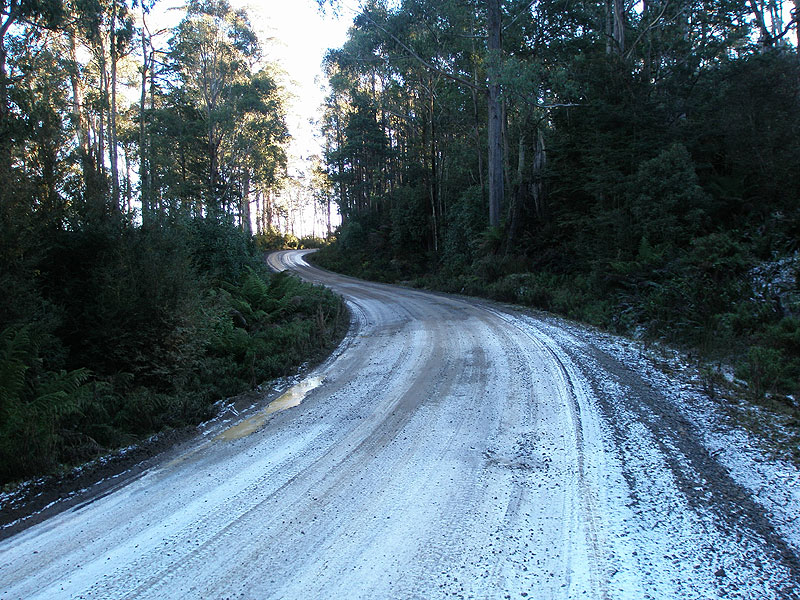
Ice and snow persist for a long time in the shadow of Mt Ben Nevis - this straight is looking east on Upper Blessington Rd (C401) approaching Gunns Rd. Source: Peter Renshaw, July 2007. |
 |
A snow-free shot of Upper Blessington Rd (C401) eastbound approaching Gunns Rd (C401), Telopea Rd & Memory Rd. C401 makes a right turn at this intersection. Source: Peter Renshaw, May 2008. |
  |
Forestry Tasmania direction signs at the intersection of Upper Blessington Rd (C401) & Gunns Rd (C401) & Memory Rd & Telopea Rd. This is one intersection along C401 which is not appropriately signposted with the standard white fingerboards. Also note no mention of C401 which makes a right-turn towards Mathinna. Top: Peter Renshaw, July 2007. Bottom: Peter Renshaw, May 2008. |
 |
Gunns Rd (C401) looking south as it begins to gently descend Roses Tier. The surface here is better than elsewhere, but still slippery. Source: Peter Renshaw, July 2007. |
 |
Gunns Rd (C401) looking south as it begins to gently descend Roses Tier. The logging traffic takes it toll on the gravel pavement, especially on bends, and when the ice and snow melt, it leaves a lot of slippery mud. Source: Peter Renshaw, July 2007. |
 |
Gunns Rd (C401) looking south, approaching the Rose Tiers Rd intersection. Note the arrangement of the fingerboard signs - perhaps AD signs with arrows pointing straight would have served traffic better. Also note how the fingerboards are not even facing Rose Tiers Rd traffic. Source: Peter Renshaw, May 2008. |
 |
Fingerboard sign assembly at the intersection of Gunns Rd (C401) & Rose Tiers Rd. Roses Tier Rd provides an alternative lower standard route across the mountains to Upper Blessington which is actually considerably shorter than the 20km journey via C401. Source: Peter Renshaw, May 2008. |
 |
Gunns Rd (C401) looking south from the junction with Rose Tiers Rd. Note the slippery surface and muddy pavement. Source: Peter Renshaw, July 2007. |
 |
Gunns Rd (C401) looking west approximately 1km east of Rose Tiers Rd. Source: Peter Renshaw, May 2008. |
 |
Gunns Rd (C401) looking east at the intersection with Joys Rd, 3km east of Rose Tiers Rd. Note the seemingly random fingerboard pointing towards Mathinna. |
 |
Close-up of the lone fingerboard sign at the intersection of Gunns Rd (C401) & Joys Rd, 22km west of Mathinna. Source: Peter Renshaw, July 2007. |
 |
Gunns Rd (C401) looking west, just east of Joys Rd. Source: Peter Renshaw, July 2007. |
 |
Gunns Rd (C401) looking east at the beginning of the final 3km descent to the South Esk River valley. Source: Peter Renshaw, July 2007. |
 |
Gunns Rd (C401) looking north near Jones Lookout with a glimpse of the South Esk River valley. Source: Peter Renshaw, May 2008. |
 |
Gunns Rd (C401) looking west on the ascent from the South Esk River valley - this is the beginning of the ice-susceptible section of C401 for westbound traffic. Source: Peter Renshaw, July 2007. |
 |
Gunns Rd (C401) looking north/east on the final descent to Upper Esk, with Mt Saddleback in the background. Source: Peter Renshaw, July 2007. |
 |
Gunns Rd (C401) looking north with Mt Saddleback in the background, 1.5km from Upper Esk Rd. Source: Peter Renshaw, May 2008. |
 |
Gunns Rd (C401) looking north to the intersection with Upper Esk Rd (C401). C401 makes a right-turn here to follow the South Esk River to Mathinna. Source: Peter Renshaw, July 2007. |
 |
Gunns Rd (C401) looking south from the intersection with Upper Esk Rd (C401), 15km west of Mathinna. Source: Peter Renshaw, July 2007. |
 |
Fingerboard and Council blade signs facing Gunns Rd (C401) traffic at the intersection with Upper Esk Rd (C401), 15km west of Mathinna. Eastbound C401 traffic regains its sealed pavement at this intersection. Source: Peter Renshaw, July 2007. |
 |
Fingerboard sign facing westbound Upper Esk Rd (C401) traffic, advising C401 traffic to make the left turn onto Gunns Rd (C401). Source: Peter Renshaw, July 2007. |
 |
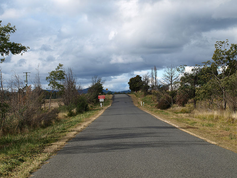
Upper Esk Rd (C401) looking east from the intersection with Gunns Rd (C401). C401 is sealed from here to Mathinna. Source: Peter Renshaw, May 2008. |
 |
Upper Esk Rd (C401) looking east approximately 500m east of Gunns Rd (C401). Note the well-maintained but narrow bitumen surface. Source: Peter Renshaw, July 2007. |
 |
Upper Esk Rd (C401) looking east towards Jimmys Creek, 14km west of Mathinna. Source: Peter Renshaw, May 2008. |
 |
Upper Esk Rd (C401) looking east across Jimmys Creek, 13.5km west of Mathinna. Source: Peter Renshaw, July 2007. |
 |
Upper Esk Rd (C401) looking east at the locality of Williams Flat, 10km west of Mathinna. Source: Peter Renshaw, May 2008. |
 |
Upper Esk Rd (C401) looking west approximately 8km west of Mathinna. Source: Peter Renshaw, May 2008. |
 |
Upper Esk Rd (C401) looking east across a series of wooden bridges crossing the Tyne River flats, approximately 6km west of Mathinna. Source: Peter Renshaw, July 2007. |
 |
Upper Esk Rd (C401) looking west across the Tyne River flats, 6km west of Mathinna. Source: Peter Renshaw, May 2008. |
 |
Upper Esk Rd (C401) looking east at an unnamed watercourse, 2km west of Mathinna. Source: Peter Renshaw, May 2008. |
 |
Upper Esk Rd (C401) looking east on the approach to Mathinna. C401 terminates at Mathinna Junction, which is located just over the crest in the distance. Source: Peter Renshaw, May 2008. |
 |
Upper Esk Rd (C401) approaching Mathinna Junction - note the unusual sign warning of the impending junction. Source: Peter Renshaw, May 2008. |
 |
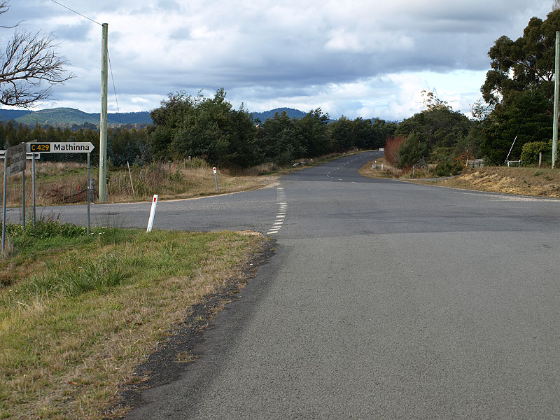
Fingerboard sign assembly at the Mathinna Junction - the intersection of Mathinna Rd (B43), Upper Esk Rd (C401), Mathinna Plains Rd (C423) & Smith St (C429) and also the terminus of four routes. Source: Peter Renshaw, May 2008. |
 |
Fingerboard sign assembly at the Mathinna Junction - the intersection of Mathinna Rd (B43), Upper Esk Rd (C401), Mathinna Plains Rd (C423) & Smith St (C429) and also the terminus of four routes. Source: Peter Renshaw, May 2008. |
 |
Upper Esk Rd (C401) looking east Mathinna Junction, showing Mathinna Rd (B43) continuing straight ahead. The evident increase in road quality is due to Mathinna Rd's former status as a Secondary Road. Source: Peter Renshaw, July 2007. |
Last updated28 October 2012 © Ozroads 2003-2012. |