EXTON to GOLDEN VALLEY |

Fingerboard sign assembly at the intersection of Bogan Rd (C501) & Quamby Brook Rd (C503), Quamby Brook. Source: Peter Renshaw, June 2007.
Introduced: 1980
Length: 14km
Northern Terminus: Meander Valley Secondary Rd (B54) & Exton Rd (C502), Exton
Southern Terminus: Lake Secondary Rd (A5) & Golden Valley Rd (C502), 15km south of Deloraine
Route taken: Exton Rd, Bogan Rd, Golden Valley Rd
Focal Points: Exton, Osmaston, Quamby Brook, Golden Valley
Responsibility: Local Government
C502 is a rural route in the Meander valley area, west of Launceston, serving a rich agricultural district. It is sealed for its entire length and also mostly devoid of line markings.
|
Photos of route C502 |
|
 |
Meander Valley Secondary Rd (B54) eastbound approaching the junction with Exton Rd (C502) at Exton. Source: Peter Renshaw, June 2007. |
 |
Fingerboard sign assembly at the intersection of Meander Valley Secondary Rd (B54) & Exton Rd (C502), Exton. The bridge in the background carries Porters Bridge Rd over the Launceston to Burnie railway line and the Bass Highway (NH1). Source: Peter Renshaw, June 2007. |
 |
Exton Rd (C502) looking south from the intersection with Meander Valley Secondary Rd (B54), Exton. Source: Peter Renshaw, August 2007. |
 |
Exton Rd (C502) looking south on a cold winter's morning approximately 1.5km south of Meander Valley Secondary Rd (B54). Source: Peter Renshaw, June 2007. |
 |
A southbound view of a short winding section of Exton Rd (C502) approximately 2km south of Meander Valley Secondary Rd (B54). Source: Peter Renshaw, June 2007. |
 |
Exton Rd (C502) looking south across Quamby Brook. The pictured curve leads into a long straight across a flat plain at Osmaston. Source: Peter Renshaw, June 2007. |
 |
Exton Rd (C502) looking south to the intersection with Osmaston Rd (C501) at Osmaston. C502 continues beyond this intersection as Bogan Rd. Source: Peter Renshaw, June 2007. |
 |
Deteriorating fingerboard sign pointing traffic northbound onto Exton Rd (C502) at the intersection with Osmaston Rd (C501). The use of the flash shows the loss of reflectivity over the years. Source: Peter Renshaw, June 2007. |
 |
The opposite side of the above fingerboard sign at the intersection of Exton Rd (C502) & Osmaston Rd (C501), Osmaston. There are no fingerboard signs showing C502's continuation to the south at this intersection. Source: Peter Renshaw, June 2007. |
 |
Bogan Rd (C502) looking south from the intersection with Osmaston Rd (C501). Source: Peter Renshaw, November 2007. |
 |
Bogan Rd (C502) looking south towards the intersection with Cluan Tiers Rd, 2km north of Quamby Brook. Source: Peter Renshaw, November 2007. |
 |
Bogan Rd (C502) looking west across a small timber bridge from the intersection with Cluan Tiers Rd. Source: Peter Renshaw, June 2007. |
|
Fingerboard sign assembly at the intersection of Bogan Rd (C501) & Quamby Brook Rd (C503), Quamby Brook. Source: Peter Renshaw, June 2007. |
 |
Bogan Rd (C502) looking south approximately 500m south of Quamby Brook Rd (C503), Quamby Brook. Source: Peter Renshaw, November 2007. |
 |
Another view a little further south as a cloud-enshrouded Quamby Bluff comes into view. Source: Peter Renshaw, November 2007. |
 |
Bogan Rd (C502) looking south as it runs through the foothills of the Quamby Brook valley. Source: Peter Renshaw, June 2007. |
  |
Bogan Rd (C502) looking south towards the junction with Golden Valley Rd (C502). As indicated, C502 turns to the right here and climbs to meet Lake Secondary Rd (A5). The first photo was taken on a foggy winter's morning. Top photo - Source: Peter Renshaw, June 2007. Bottom photo - Source: Peter Renshaw, November 2007. |
 |
Fingerboard signs facing Golden Valley Rd (C502) at the intersection with Bogan Rd (C502), 4km south of Quamby Brook. Note the C504 fingerboard sign which remains many years following its decommissioning. Source: Peter Renshaw, June 2007. |
 |
Golden Valley Rd (C502) looking west from the intersection with Bogan Rd (C502). Source: Peter Renshaw, June 2007. |
 |
Golden Valley Rd (C502) looking east between Bogan Rd (C502) and Golden Valley. Source: Peter Renshaw, June 2007. |
 |
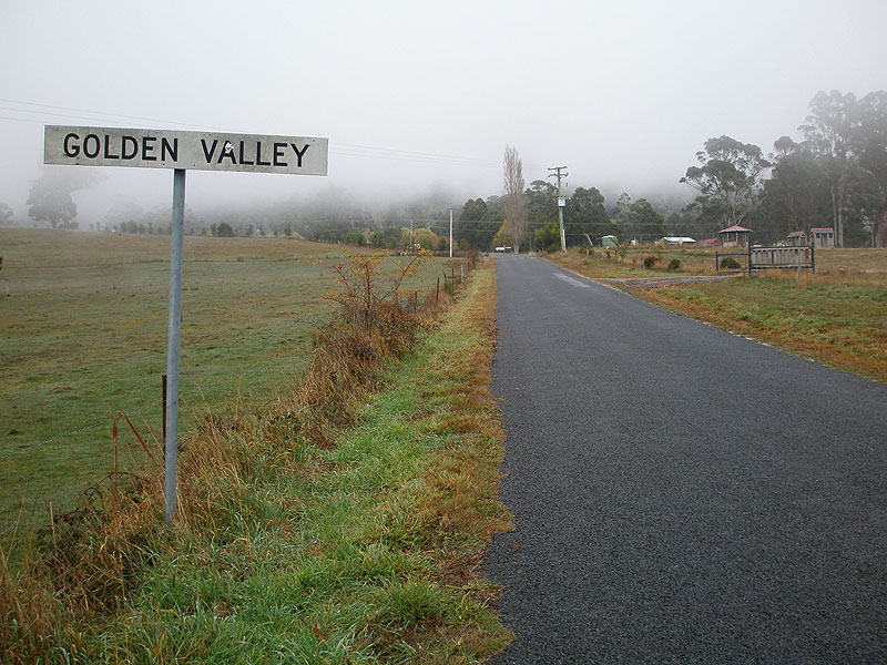
Golden Valley Rd looking east from Golden Valley. Source: Peter Renshaw, June 2007. |
A long view towards the Lake Secondary Rd (A5) intersection and southern terminus of C502 with Quamby Bluff an imposing backdrop. Source: Peter Renshaw, November 2007. |
|
 |
Golden Valley Rd (C502) looking west into the hamlet of Golden Valley. The intersection with Lake Secondary Rd (A5) is in the distance. Source: Peter Renshaw, June 2007. |
 |
Fingerboard sign assembly at the intersection of Lake Secondary Rd (A5) & Golden Valley Rd (C502), Golden Valley. This is the southern terminus of C502. Source: Peter Renshaw, June 2007. |
Last updated 26 January 2009. © Ozroads 2004-2009. |