St Helens to Binalong Bay |

Fingerboard sign facing southbound traffic at the junction of Lisle Rd (C827) & Nook Rd, 4km south of Nabowla. Source: Peter Renshaw, March 2008.
Introduced: 1980
Length: 11km
Northern Terminus: Binalong Bay
Southern Terminus: Tasman Highway (A3) & Quail St, St Helens
Route taken: Quail St, Binalong Bay Rd
Focal Points: St Helens, Binalong Bay
Responsibility: Local Government
C850 is an 11km long spur route on the eastern coast of Tasmania, linking St Helens with the holiday village of Binalong Bay and the beautiful Bay of Fires Conservation Area. C850 is fully sealed along its length and links with both C848 and C849, 3km west of Binalong Bay.
Recent improvements to the route include the replacement of timber beam bridges over Colchis Creek and George River, both completed in 2007.1
Notable Events:
2007 - Replacement of timber bream bridges over Colchis Creek and George River
References:
1. Break O'Day Council, Break O'Day News, Summer 2007, available from: http://www.bodc.tas.gov.au/webdata/resources/files/31166_bod_summer_07_nl.pdf
|
Photos of route C850 |
|
 |
AD sign southbound on Tasman Hwy (A3) approaching the junction with Quail St (C850), St Helens. |
| |
AD sign northbound on Tasman Hwy (A3) approaching the junction with Quail St (C850), St Helens. |
 |
Non-standard blade signage installed by Break O'Day Council at the intersection of Tasman Hwy (A3) & Quail St (C850), St Helens. Attempts to have proper fingerboard signs, which previously existed at this intersection, reinstated have not yet been successful. |
 |
Quail St (C850) looking west through St Helens with the Tasman Hwy (A3) junction in the distance. Source: Peter Renshaw, May 2008. |
 |
Quail St (C850) looking east at Cameron St, St Helens, with the transition to Binalong Bay Rd located in the distance. Source: Peter Renshaw, May 2008. |
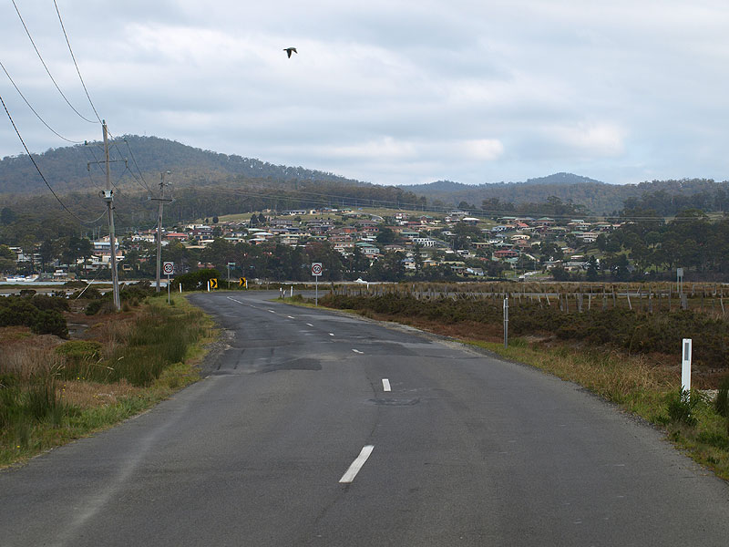
| Binalong Bay Rd (C850) looking south approaching the curve into Quail St on the eastern outskirts of St Helens. The residential area south of the river can be seen in the background. | |
 |
Binalong Bay Rd (C850) looking south towards the bridge over Colchis Creek with St Helens in the background. The timber beam bridge at this location was replaced by this concrete structure in 2007. Source: Peter Renshaw, April 2008. |
 |
Binalong Bay Rd (C850) looking east across the floodplain between Colchis Creek and George River. Source: Peter Renshaw, May 2008. |
 |
Binalong Bay Rd (C850) looking east across the floodplain between Colchis Creek and George River. Source: Peter Renshaw, May 2008. |
 |
Binalong Bay Rd (C850) looking east at the bridge over George River, 2km east of St Helens. Source: Peter Renshaw, May 2008. |
 |
Binalong Bay Rd (C850) looking south alongside Georges Bay, 3km east of St Helens. Source: Peter Renshaw, May 2008. |
 |
Recently reconstructed and widened section of Binalong Bay Rd (C850), looking south 4km east of St Helens. Source: Peter Renshaw, May 2008. |
 |
Binalong Bay Rd (C850) looking north near Nicks Cl, 6km northeast of St Helens. Source: Peter Renshaw, May 2008. |
 |
Binalong Bay Rd (C850) looking north towards the junction with The Gardens Rd (C848), 8km north of St Helens. Source: Peter Renshaw, May 2008. |
 |
AD sign northbound on Binalong Bay Rd (C850) approaching the junction with The Gardens Rd (C848). Note no mention of C849, despite the fact that it branches off C848 less than 100m from its junction with C850. There are also no C850 fingerboard signs at the C850/C848 junction! Source: Peter Renshaw, April 2008. |
 |
Fingerboard signs at the turnoff for Humbug Point, located just beyond the C850/C848 junction. Note the incorrect omission of C850 from the fingerboard pointing towards Binalong Bay. Source: Peter Renshaw, April 2008. |
 |
Binalong Bay Rd (C850) looking south towards the junction with The Gardens Rd (C848). Note the fingerboard sign in the distance omits reference to C848.
Source: Peter Renshaw, April 2008. |
 |
Binalong Bay Rd (C850) looking south near the outskirts of Binalong Bay. Source: Peter Renshaw, May 2008. |
 |
Binalong Bay Rd (C850) looking northeast into the town of Binalong Bay. Source: Peter Renshaw, May 2008. |
  |
Typical views of Binalong Bay Rd (C850) through the town of Binalong Bay.
Source: Peter Renshaw, May 2008. |
 |
Binalong Bay Rd (C850) looking east as you approach the end of the route at Binalong Bay. Source: Peter Renshaw, May 2008. |
Last updated 16 April 2011 © Ozroads 2004-2011. |