Nile to Blessington |

Fingerboard sign assembly at the intersection of Deddington Rd (C420) & Bryants Lane (C419), Deddington. Source: Peter Renshaw, July 2007.
Introduced: 1980
Length: 25km
Northern Terminus: Blessington Rd (C401) & Deddington Rd (C420), 3km north of Blessington
Southern Terminus: Nile Rd (C416) & Deddington Rd (C420), 1km south of Nile
Route taken: Deddington Rd
Focal Points: (Nile), Deddington, Blessington
Responsibility: Local Government
C420 is a 25km long, partly unsealed route in northern Tasmania. It forms part of the shortest route between Ben Lomond and the southern part of the state, although is not signposted as such due to the low standard of construction. The southern portion, from Deddington to Nile, has a 6 tonne load limit.
Commencing near the tiny village of Nile, C420 runs east across the Nile River flats through the hamlet of Deddington before crossing the river at Lilyburn Bridge. It then climbs steadily up Pinchgut Hill to the village of Blessington before descending into the North Esk River valley to link with C401.
Approximately 11km of the route is sealed, with the remaining 14km a generally well-maintained gravel surface.
|
Photos of route C420 |
|
Top: Deteriorating C420 fingerboard sign at the intersection of Nile Rd (C416) & Deddington Rd (C420), 1km south of Nile. This sign has seen been replaced. Bottom: Original 1980s C416 fingerboard sign at the intersection of Nile Rd (C416) & Deddington Rd (C420). The left-pointing fingerboard was probably removed to discouraged unfamiliar traffic from reaching the Midland Highway (NH1) via the partly unsealed C416. |
|
  |
Replacement fingerboard signs at the junction of Nile Rd (C416) & Deddington Rd (C420), 1km south of Nile. Source: Peter Renshaw, October 2012. |
 |
Deddington Rd (C420) looking west to the junction with Nile Rd (C416), 1km south of Nile. |
 |
Deddington Rd (C420) looking east near Glen Mavis, 2.5km east of Nile Rd (C416). |
 |
Deddington Rd (C420) looking east near Ben Balls Island on the Nile River flats, 4.5km east of Nile Rd (C416). Source: Peter Renshaw, July 2007. |
Deddington Rd (C420) looking west 6.6km east of Nile Rd (C416) with the distant Macquarie Tiers as a backdrop. Source: Peter Renshaw, July 2007. |
|
 |
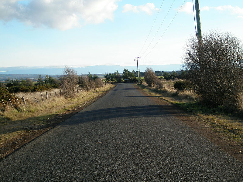
Deddington Rd (C420) looking east near Hampden, 7.5km east of Nile Rd (C416). |
 |
Deddington Rd (C420) looking south from the junction with Bryants Lane (C419) at Deddington. |
|
Fingerboard sign assembly at the intersection of Deddington Rd (C420) & Bryants Lane (C419), Deddington. There is no reference to C419 at this junction. Also note the old wooden blade sign pointing to Ben Lomond - C416 and C420 form part of the shortest route between the south of the state and Ben Lomond. Source: Peter Renshaw, June 2007. |
 |
Deddington Rd (C420) looking north at Deddington. |
 |
Deddington Rd (C420) looking south into Deddington. Source: Peter Renshaw, July 2007. |
 |
Just north of Deddington the sealed surface makes way for gravel - looking north 1km north of Deddington. Source: Peter Renshaw, July 2007. |
 |
Deddington Rd (C420) looking east, 2km north of Deddington. Source: Peter Renshaw, July 2007. |
 |
At Uplands Rd, Deddington Rd (C420) makes a sharp left turn which is unsignposted, 3km north of Deddington. Source: Peter Renshaw, July 2007. |
 |
Deddington Rd (C420) looking north, 500m south of Lilyburn Bridge over Nile River, 5.4km north of Deddington. Source: Peter Renshaw, June 2007. |
 |
Deddington Rd (C420) looking south at Lilyburn Bridge over Nile River, 6km north of Deddington. Source: Peter Renshaw, June 2007. |
 |
North of the Nile River, Deddington Rd (C420) steadily climbs towards Blessington. This view is looking south across the Nile River valley, 1.5km north of Lilyburn Bridge. Source: Peter Renshaw, July 2007. |
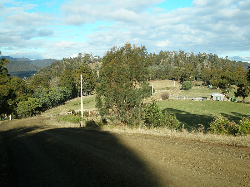 |
Deddington Rd (C420) looking south on the descent from Pinchgut Hill away from Blessington. Source: Peter Renshaw, June 2007. |
 |
Deddington Rd (C420) looking north along the undulating land above Pinchgut Hill. Blessington village is located only 1km away. Source: Peter Renshaw, June 2007. |
 |
A good view of the switchbacks on the climb to the summit, looking north. Source: Peter Renshaw, July 2007. |
 |
Deddington Rd (C420) looking north to the junction with Sawpit Hill Rd (C413) at Blessington. Source: Peter Renshaw, July 2007. |
 |
Fingerboard signs at the intersection of Deddington Rd (C420) & Sawpit Hill Rd (C413), Blessington. Note the absence of a focal destination for northbound C420 traffic. Source: Peter Renshaw, June 2007. |
 |
Deddington Rd (C420) looking north from Hayes Rd at Blessington. From here, Deddington Rd (C420) descends as a sealed carriageway to the junction with Blessington Rd (C401). Source: Peter Renshaw, July 2007. |
 |
The final stretch of C420 viewed from the hills behind Blessington. C420 runs from left-to-right across the picture, meeting C401 at the clump of trees on the left. Source: Peter Renshaw, July 2007. |
 |
Deddington Rd (C420) looking south from Blessington Rd (C401). Source: Peter Renshaw, July 2007. |
  |
Top: Original fingerboard signs at the intersection of Blessington Rd (C401) & Deddington Rd (C420), 3km north of Blessington. Following the disappearance of the C420 fingerboards in 2008, DIER provided a replacement pair. This set has omitted reference to the connecting route to reach Nile (C419), as is the current signposting policy. |


Last updated 30 October 2012 © Ozroads 2003-2012. |