Burnside - North Scottsdale - Tulendeena |

Fingerboard sign assembly at the junction of Bridport Main Rd (B84) & Burnside Rd (C831), 3km north of Scottsdale. Source: Peter Renshaw, October 2007.
Introduced: 1980
Length: 17km
Eastern Terminus: Tasman Highway (A3) & Jensens Rd (C831), 11km east of Scottsdale
Western Terminus: Bridport Main Rd (B84) & Burnside Rd (C831), 3km north of Scottsdale
Route taken: Burnside Rd, North Scottsdale Rd, Jensens Rd
Focal Points: (North Scottsdale)
Responsibility: Local Government
C831 forms a loop from east of Scottsdale to north of Scottsdale, functioning as an eastern ring road (if there ever was a need for such a thing). The route is split into two distinctive sections by C832, which intersects with C831 5km east of Scottsdale. The northern section of the route (Burnside & North Scottsdale Roads) is partly sealed and serves rich agricultural lands. The southern section of the route (Jensens Road) is completely unsealed, running through mostly forested areas with the exception of the secluded Forester Flats farming community.
A short duplex with C832 is located along an approximately 30m long section of North Scottsdale Rd. In typical Tasmanian style this duplex is not signed, however the close proximity of the intersections means that most traffic would not have too much trouble working out how to follow C831. Jensens Rd unfortunately includes two unsigned junctions - one with an unnamed foresty road and one with Burrows Rd - which could potentially see motorists choose an incorrect route.
|
Photos of route C831 |
|
 |
AD sign northbound on Bridport Main Rd (B82) approaching the junction with Burnside Rd (C831), 3km north of Scottsdale. Source: Peter Renshaw, April 2009. |
 |
AD sign southbound on Bridport Main Rd (B82) approaching the junction with Burnside Rd (C831), 3km north of Scottsdale. Source: Peter Renshaw, April 2009. |
| Top: Fingerboard sign assembly at the junction of Bridport Main Rd (B84) & Burnside Rd (C831), 3km north of Scottsdale. Bottom: New fingerboard sign assembly at the junction of Bridport Main Rd (B84) & Burnside Rd (C831), 3km north of Scottsdale. | |
 |
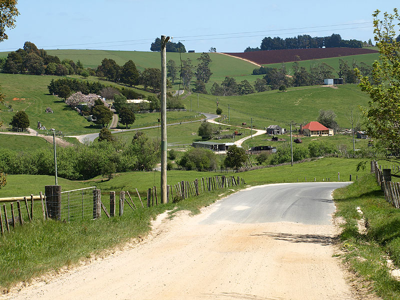
Burnside Rd (C831) looking northeast from the junction with Bridport Main Rd (B84), showing the descent towards Coxs Rivulet. |
| Burnside Rd (C831) looking northeast on the descent to Coxs Rivulet, 700m east of Bridport Main Rd (B84). | |
 |
Burnside Rd (C831) looking northeast across a small valley east of Coxs Rivulet, 1.7km east of Bridport Main Rd (B84). The end of the sealed surface can be seen in the distance. |
 |
Burnside Rd (C831) looking west from the end of the sealed surface, 2.5km east of Bridport Main Rd (B84). Source: Peter Renshaw, October 2007. |
 |
Burnside Rd (C831) looking northeast to the junction with Barnbougle Rd, 3.7km east of Bridport Main Rd (B84). Note the strange placement of the fingerboard signs not facing the side road. Source: Peter Renshaw, October 2007. |
| Close-up of fingerboard signs at the junction of Burnside Rd (C831) & Barnbougle Rd, 3.7km east of Bridport Main Rd (B84). Barnbougle Rd is behind the signs, to the left. | |
Burnside Rd (C831) makes a sharp turn just north of Barnbougle Rd and then heads east around the side of Mt Zion and towards North Scottsdale Rd. This view is looking southeast across Tuckers Creek, 4.2km from Bridport Main Rd (B84). Source: Peter Renshaw, October 2007. |
|
 |
Burnside Rd (C831) looking east from Mt Zion, 5km from Bridport Main Rd (B84). Source: Peter Renshaw, October 2007. |
 |
Burnside Rd (C831) looking east to the junction with North Scottsdale Rd (C831). C831 makes a sharp turn to the south onto North Scottsdale Rd at this junction. Source: Peter Renshaw, October 2007. |
 |
Old fingerboard sign assembly at the junction of North Scottsdale Rd (C831) & Burnside Rd (C831), 6km from Bridport Main Rd (B84). Note the absence of signage pointing C831 traffic south along North Scottsdale Rd. Note the beginning of the sealed surface in the distance. Source: Peter Renshaw, April 2009. |
 |
New fingerboard assembly (installed in the latter half of 2009) at the junction of North Scottsdale Rd (C831) & Burnside Rd (C831), looking north. Note there is still no C831 signage pointing south. Source: Peter Renshaw, December 2009. |
 |
North Scottsdale Rd (C831) looking south towards the junction with Old Waterhouse Rd (C832), 1km south of Burnside Rd. Source: Peter Renshaw, October 2007. |
  |
Fingerboard signs at the junction of North Scottsdale Rd (C831/C832) & Old Waterhouse Rd (C832), 5km northeast of Scottsdale. C831 has a short (~30m) duplex with C832 along the section of North Scottsdale Rd between Old Waterhouse Rd and Jensens Rd, however it is not signed properly. Top photo : Peter Renshaw, October 2007. Bottom photo : Peter Renshaw, April 2008. |
 |
Fingerboard sign assembly at the junction of North Scottsdale Rd (C831/C832) & Jensens Rd (C831). Note the absence of any reference to C831 for the right turn and subsequent quick left turn. Source: Peter Renshaw, October 2007. |
 |
Jensens Rd (C831) looking east, 200m from the junction with North Scottsdale Rd (C832). Source: Peter Renshaw, October 2007. |
 |
Jensens Rd (C831) looking east at the junction with an unnamed forestry road, 4km east of North Scottsdale Rd (C832). Jensens Rd curves around the to the left.
Source: Peter Renshaw, October 2007. |
Jensens Rd (C831) looking east as it begins the descent to Forester Flats, 5km east of North Scottsdale Rd (C832). Source: Peter Renshaw, October 2007. |
|
 |
Unsigned junction of Jensens Rd (C831) & Burrows Rd, 5.5km from North Scottsdale Rd (C832). If you didn't have a map you wouldn't know which way to go! Source: Peter Renshaw, October 2007. |
The first glimpse of Forester Flats - Jensens Rd (C831) looking east, 6km east of North Scottsdale Rd (C832).
Source: Peter Renshaw, October 2007. |
|
 |
A side view of the timber bridge carrying Jensens Rd (C831) over Great Forester River at Forester Flats, 3.6km north of Tasman Highway (A3). Source: Peter Renshaw, October 2007. |
 |
Jensens Rd (C831) looking south at the southern end of Forester Flats, 2.5km north of Tasman Highway (A3). Source: Peter Renshaw, October 2007. |
 |
Typical view of Jensens Rd (C831) southbound through the forested section in the last 2.5km north of Tasman Highway (A3). Source: Peter Renshaw, October 2007. |
 |
Jensens Rd (C831) looking south on the final curved approach to the junction with Tasman Highway (A3), 11km east of Scottsdale. Source: Peter Renshaw, October 2007. |
 |
The original fingerboard sign assembly at the junction of Tasman Highway (A3) & Jensens Rd (C831), 11km east of Scottsdale. Source: Peter Renshaw, April 2007. |
New fingerboard sign assemblies installed early in 2009 at the junction of Tasman Highway (A3) & Jensens Rd (C831), 11km east of Scottsdale. Note the new practice of using of the road name for C routes without focal destinations (although surely North Scottsdale could have been considered appropriate). Source: Peter Renshaw, April 2009. |
|
 |
New AD sign (installed early 2009) eastbound on Tasman Highway (A3) approaching the junction with Jensens Rd (C831), 11km east of Scottsdale. |
 |
New AD sign (installed early 2009) westbound on Tasman Highway (A3) approaching the junction with Jensens Rd (C831), 11km east of Scottsdale. Source: Peter Renshaw, April 2009. |


Last updated 20 March 2010 © Ozroads 2004-2010. |