Mount Barrow |

Mount Barrow Tourist Road (C404) looking north from near the summit of Mount Barrow, showing the switchbacks of the steep climb out of the St Patricks River valley. Source: Peter Renshaw, November 2007.
Introduced: 1980
Length: 14km
Western Terminus: Tasman Highway (A3) & Mt Barrow Rd (C404), 28km east of Launceston
Eastern Terminus: Mount Barrow summit
Route taken: Mt Barrow Rd, Mt Barrow Tourist Rd
Focal Points: Mt Barrow
Responsibility: State Government (Mt Barrow Tourist Rd) Local Government (Mt Barrow Rd)
C404 is a 14km long, unsealed spur route in northern eastern Tasmania, linking the Tasman Highway (A3) with Mount Barrow State Reserve. The route mainly serves tourist traffic bound for picnic areas, bushwalks and the spectacular views from the summit of Mount Barrow. The mountain also houses important communications infrastructure, with transmission towers broadcasting radio and television signals to Launceston and surrounds.
The first 10km of the route has a well-maintained gravel surface and runs through a combination of undulating farmland and forestry areas. The boundary of Mount Barrow State Reserve is reached at the 10km mark, where parking and picnic areas are provided. The road beyond the parking area is officially closed to vehicles other than four wheel drives, however the road was driven in a Subaru Liberty several times in 2007 without encountering any problems. The road beyond the reserve boundary is certainly worth the drive. It comprises of a tortuous, steep collection of switchbacks - rivalling nearby Jacobs Ladder - but also provides spectacular views of the valleys to the north and west. The last 1.5km is located above the tree line, at around 1000m above sea level, and is the nearest location to Launceston that regularly gets winter snowfalls.
The route is under the care and control of Launceston City Council west of Mount Barrow State Reserve. Within Mount Barrow State Reserve, including the four-wheel-drive-only climb to the summit, it is classified as Mount Barrow Tourist Road and is under the care and control of the Department of Infrastructure, Energy and Resources (DIER).
|
Photos of route C404 |
|
Top: AD sign westbound on Tasman Highway (A3) approaching the junction with Mt Barrow Rd (C404), 28km east of Launceston. Bottom: New AD sign on a realigned section of Tasman Highway (A3) approaching the junction with Mt Barrow Rd (C404). The original AD sign remains in situ alongside the old alignment of the road, 25 metres or so to the left of the present alignment. |
|
 |
AD sign eastbound on Tasman Highway (A3) approaching the junction with Mt Barrow Rd (C404), prior to the reconstruction of the highway. |
  |
Top: Fingerboard signs at the junction of Tasman Highway (A3) & Mt Barrow Rd (C404), prior to its reconstruction. Bottom: Fingerboard signs at the reconstructed junction of Tasman Highway (A3) & Mt Barrow Rd (C404). Note the brown 'tourist' fingerboard for Mt Barrow and the expanded legend. |
 |
Mt Barrow Rd (C404) looking east from Tasman Highway (A3). Source: Peter Renshaw, April 2008. |
 |
Mt Barrow Rd (C404) looking east, 600m east of Tasman Highway (A3). |
 |
Mt Barrow Rd (C404) looking east towards the small timber bridge over Barrow Creek, 1.7km east of Tasman Highway (A3). |
 |
Mt Barrow Rd (C404) looking east, showing the first glimpse of the destination - Mt Barrow - 2.3km east of Tasman Highway (A3). Source: Peter Renshaw, July 2007. |
 |
Mt Barrow Rd (C404) looking east at the junction with Neils Rd, 3km east of Tasman Highway (A3). |
 |
Mt Barrow Rd (C404) looking west towards Neils Rd, 3.3km east of Tasman Highway (A3). Source: Peter Renshaw, July 2007. |
 |
Mt Barrow Rd (C404) looking west towards Neils Rd, 4km east of Tasman Highway (A3). Source: Peter Renshaw, July 2007. |
 |
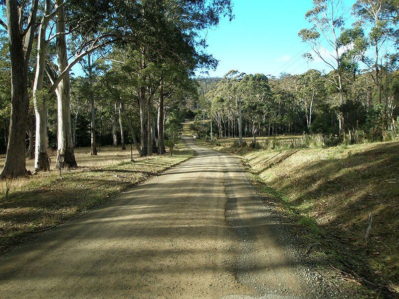
Mt Barrow Rd (C404) looking east inside Barrow Falls State Reserve, 6km east of Tasman Highway (A3). Source: Peter Renshaw, July 2007. |
 |
Sign warning motorists about frost, ice and snow, approaching Mount Barrow State Reserve, 8km east of Tasman Highway (A3). Source: Peter Renshaw, July 2007. |
 |
Mt Barrow Rd (C404) looking east at the boundary of Mt Barrow State Reserve, 10km east of Tasman Highway (A3). Mt Barrow Rd becomes Mt Barrow Tourist Rd at this point. Parking and picnic areas are located behind the sign. Source: Peter Renshaw, November 2007. |
 |
Old signage probably dating from the 1980s just beyond the parking area at the boundary of Mt Barrow State Reserve, prohibiting vehicles other than four wheel drives from travelling on Mt Barrow Tourist Rd to the summit. 'DENE DMR' probably stands for 'District Engineer North East, Department of Main Roads'. Source: Peter Renshaw, November 2007. |
 |
Mt Barrow Tourist Rd (C404) looking south towards the summit, approximately 500m beyond the above photo. Source: Peter Renshaw, November 2007. |
Mt Barrow Tourist Rd (C404) looking north towards the picnic area, 3km north of of the summit. Source: Peter Renshaw, November 2007. |
|
 |
Mt Barrow Tourist Rd (C404) looking south as it emerges beyond the tree line and begins the precipitous climb to the summit. Source: Peter Renshaw, November 2007. |
 |
A good view of the switchbacks on the climb to the summit, looking north. Source: Peter Renshaw, November 2007. |
 |
Another view towards a lower part of Mt Barrow Tourist Rd (C404), approximately 1.5km from the summit. Source: Peter Renshaw, November 2007. |
A panoramic view north over the tortuous alignment of Mt Barrow Tourist Rd (C404), 500m from the summit. |
|
 |
Mt Barrow Tourist Rd (C404) looking south towards the mist-clouded summit. Source: Peter Renshaw, November 2007. |
 |
A close-up of the one of the tight hairpin bends, looking north near the summit. Source: Peter Renshaw, November 2007. |
 |
These are the views that bring the tourists - Mt Barrow Tourist Rd (C404) looking north near the summit. Source: Peter Renshaw, November 2007. |
 |
Cairn with missing plaque at the summit of Mount Barrow. This is the eastern terminus of C404 and Mt Barrow Tourist Rd. Source: Peter Renshaw, November 2007. |
 |
Communications huts at the summit of Mount Barrow. Source: Peter Renshaw, November 2007. |
The road continues south towards South Barrow (where the communications towers are located), beyond the summit of Mount Barrow, but is gated off to general traffic. |
|


Last updated 7 June 2009 © Ozroads 2004-2009. |