Longford - Campbell Town |

C520 (Wellington Street) looking north towards its junction with B51 (Poatina Main Road) in Longford. Source: Josh Geoghegan, Dec 2004.
Introduced: 1980
Length: 49km
Eastern Terminus: Macquarie Rd (C522) & Valleyfield Road (C520), 6km west of Campbell Town
Western Terminus: Poatina Main Road (B51) & Wellington St (C520), Longford
Route taken: From the intersection of Macquarie Rd (C522) and Valleyfield Road, 6km west of Campbell Town, via Valleyfield Road, Mount Joy Road, Chintah Road, Panshanger Road, Woolmers Lane and Wellington Street, to the intersection of Poatina Main Road (B51) and Wellington St, Longford.
Focal Points: Longford, Campbell Town
Responsibility: Local Government
C520 is a minor rural route in north-central Tasmania, connecting the towns of Longford and Campbell Town. It provides a link between the Midland Highway and the Illawarra Main Road along the eastern bank of the Macquarie River, however because of its lower design standard, indirect route and unsealed pavement it is not used by through traffic. It functions as a lower-order leg of the rural road network.
C520 is typical of C routes in the northern Midlands area of Tasmania, characterised by long straights and right-angle bends as it sticks to long established property boundaries. The absence of C520 signage along much of the route indicates that perhaps Council wants to avoid any through traffic using the route.
|
Photos of route C520 |
|
Poatina Main Rd (B51) looking south approaching the junction with Wellington St (C520) in Longford. Note the unusual design and absence of both B51 and C520. Complaints have been made to both DIER and Longford Council. Source: Peter Renshaw, January 2008. |
|
 |
Poatina Main Road (B51) looking south at the junction with Wellington St (C520) in Longford. Note the absence of any directional signs indicating the beginning of C520, or the path of B51. Source: Peter Renshaw, June 2007. |
 |
Wellington St (C520) looking south from the junction with B51 (Poatina Main Rd). Source: Peter Renshaw, June 2007. |
|
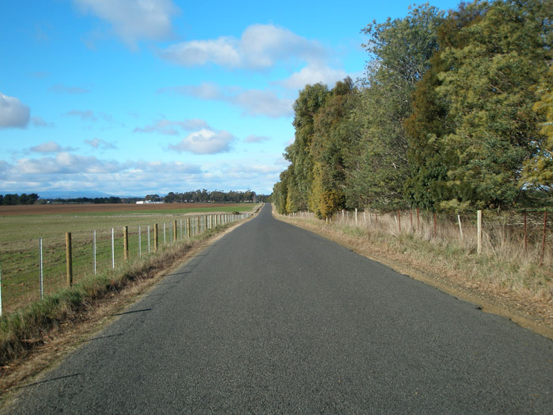
C520 (Wellington Street) looking north towards its junction with B51 (Poatina Main Road) in Longford. This is the western terminus of C520. Source: Josh Geoghegan, Dec 2004. |
 |
Wellington St (C520) looking south near Malcombe St, Longford, where the kerb and guttering begins to disappear. Source: Peter Renshaw, June 2007. |
 |
Wellington St (C520) looking north near the junction with Hobhouse St, Longford. Source: Peter Renshaw, June 2007. |
 |
Wellington St (C520) looking south on the outskirts of Longford, approaching Brickendon Estate. Source: Peter Renshaw, June 2007. |
 |
Wellington St (C520) looking south at Cracroft St, the enterance to Brickendon Estate - one of the main reasons for C520's existence. Source: Peter Renshaw, June 2007. |
 |
Woolmers Lane (C520) looking east after C520 makes the first of several right-angle turns, at Brickendon Estate. Source: Peter Renshaw, June 2007. |
 |
Woolmers Lane (C520) looking west where it crosses the Macquarie River, about 4km south of Longford. Source: Peter Renshaw, June 2007. |
 |
Woolmers Lane (C520) looking west towards the crossing of the Macquarie River. Source: Peter Renshaw, June 2007. |
 |
Fingerboard signs at the junction of Woolmers Lane (C520/C521) & Panshanger Rd (C520), 6km south-east of Longford. Woolmers Lane continues east to the Midland Highway (NH1) as C521, whilst C520 turns south onto Panshanger Road - not that you would realise as there is no sign pointing C520 down Panshanger Road. Source: Peter Renshaw, June 2007. |
 |
Panshanger Rd (C520) looking south from the junction with Woolmers Lane (C520/C521), 6km south-east of Longford. Source: Peter Renshaw, June 2007. |
 |
Panshanger Rd (C520) looking south between Woolmers Lane (C521) and Chintah Road. Source: Peter Renshaw, June 2007. |
 |
Panshanger Rd (C520) looking south between Woolmers Lane and Chintah Rd, showing undulating agricultural country. Source: Peter Renshaw, June 2007. |
 |
Panshanger Road (C520) southbound, showing a rare curve in the usually straight route. Source: Peter Renshaw, June 2007. |
 |
Panshanger Road (C520) looking south approaching Chintah Road, where C520 makes another right-angle turn. Source: Peter Renshaw, June 2007. |
 |
Chintah Road (C520) looking east from Panshanger Road. Source: Peter Renshaw, June 2007. |
 |
Chintah Road (C520) takes another right-angle bend, thence turning south to cross a small watercourse en route to Powranna Rd (B53). Source: Peter Renshaw, June 2007. |
 |
Chintah Road (C520) looking south across a small watercourse, about 6km north of Powranna Rd (B53). Source: Peter Renshaw, June 2007. |
 |
Chintah Road (C520) looking south, about 4km north of Powranna Rd (B53). Source: Peter Renshaw, June 2007. |
 |
Chintah Rd (C520) looking east from Spencers Rd, showing recently reconstructed bitumen surface and the final bend before the junction with Powranna Rd (B53). Source: Peter Renshaw, June 2007. |
 |
Chintah Rd (C520) looking south along the final straight before Powranna Rd (C520). Source: Peter Renshaw, June 2007. |
 |
Chintah Rd (C520) looking south approaching Powranna Rd (B53). Source: Peter Renshaw, June 2007. |
 |
Chintah Rd (C520) looking south at Powranna Rd (B53). C520 continues straight through the intersection as Mt Joy Rd, however there is not a single directional sign located at this junction to tell drivers that! Source: Peter Renshaw, June 2007. |
 |
I've resorted to showing you Council blade signage - the only signage present at the intersection of Powranna Rd (B53) & Chintah Rd (C520) & Mount Joy Rd (C520). Source: Peter Renshaw, June 2007. |
 |
A wide view of the junction, westbound on Powranna Rd (B53), showing the absence of directional signs. Source: Peter Renshaw, June 2007. |
 |
Mount Joy Rd (C520) looking south, south of Powranna Rd (B53). Source: Peter Renshaw, June 2007. |
 |
Mount Joy Rd (C520) looking south through the Hummocky Hills, south of Powranna Rd. Source: Peter Renshaw, June 2007. |
 |
Mount Joy Rd (C520) looking south with Millers Bluff in the background. Source: Peter Renshaw, June 2007. |
 |
Mount Joy Rd (C520) looking south near the Hummocky Hills. This section of C520 provides some marvellous views of the agricultural river plains and the spectacular Great Western Tiers. Source: Peter Renshaw, June 2007. |
 |
Mount Joy Rd (C520) looking south towards a long S-curve about 2km north of the Barton Road intersection. It is evident that this section of Mount Joy Rd has been freshly sealed in the past two years. Source: Peter Renshaw, June 2007. |
 |
Mount Joy Rd (C520) looking south towards a single-lane bridge, north of Barton Rd. Source: Peter Renshaw, June 2007. |
 |
Mount Joy Rd (C520) looking south approaching Barton Rd junction, 33km south of Longford. C520 continues straight through the junction, becoming Valleyfield Road. Source: Peter Renshaw, June 2007. |
 |
A view of the intersection of Mount Joy Rd (C520) & Valleyfield Rd (C520) & Barton Rd, looking north. Ageing fingerboard signs are present facing Barton Rd traffic and are the first mention of C520 since the junction with C521, 27km north of here. Source: Peter Renshaw, June 2007. |
 |
Fingerboard sign at the junction of Mount Joy Rd (C520) & Valleyfield Rd (C520) & Barton Rd, 33km south of Longford. Source: Peter Renshaw, March 2008. |
 |
Valleyfield Rd (C520) looking south, south of Barton Rd. Source: Peter Renshaw, June 2007. |
 |
Valleyfield Rd (C520) looking south with Mt Augusta and Macquarie Tier in the distance. Source: Peter Renshaw, June 2007. |
 |
Valleyfield Rd (C520) looking north - note the extremely frosty ground, a very cold Tasmanian winter morning. Source: Peter Renshaw, June 2007. |
 |
Valleyfield Rd (C520) looking south approaching a single-lane bridge over Blacksmith Creek. At its southern end, C520 gets curvier and the country gets hillier as we enter the Macquarie River hinterland. Source: Peter Renshaw, June 2007. |
 |
Valleyfield Rd (C520) looking south about 2km north of Macquarie Rd (C522) as the curves begin. Source: Peter Renshaw, June 2007. |
 |
Valleyfield Rd (C520) looking south about 1.5km north of Macquarie Rd (C522). Source: Peter Renshaw, June 2007. |
 |
Valleyfield Rd (C520) looking north from the junction with Macquarie Rd (C522). Note the route is now quite high above the Macquarie River plains. Source: Peter Renshaw, June 2007. |
  |
Fingerboard signs at the junction of Valleyfield Rd (C520) & Macquarie Rd (C522) facing northbound C522 traffic. Note the incorrect reference to 'C51' - should be B51. Also note the coverplate with C520 on it - a rare instance of coverplating in Tasmania. Source: Peter Renshaw, June 2007. |
 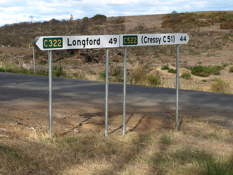 |
Replacement fingerboard signs installed in late 2007 or early 2008 perpetuating the silly 'C51' error and incorrectly referring to C322 instead of C520. Source: Peter Renshaw, March 2008. |
 |
Macquarie Road (C522) looking north-west towards the junction with Valleyfield Rd (C520), which splits off to the right. Source: Peter Renshaw, June 2007. |
Last updated 26 July 2009 © Ozroads 2004-2009. |