Breadalbane - Evandale - Leighlands |

B41 (Evandale Rd) heading south from the junction with Midland Highway (NHR1) at Breadalbane. Source: Peter Renshaw, April 2007.
Introduced: 1980
Length: 12km
Northern Terminus: Midland Highway (NHR1) & Hobart Rd (C402) & Evandale Rd (B41), Breadalbane
Southern Terminus: Midland Highway (NHR1) & Leighlands Rd (B41), 4km south of Perth
Route taken: Evandale Road, Leighlands Road
Focal Points: (Campbell Town), Evandale/Ben Lomond National Park, Launceston Airport, (Launceston)
Responsibility: State Government
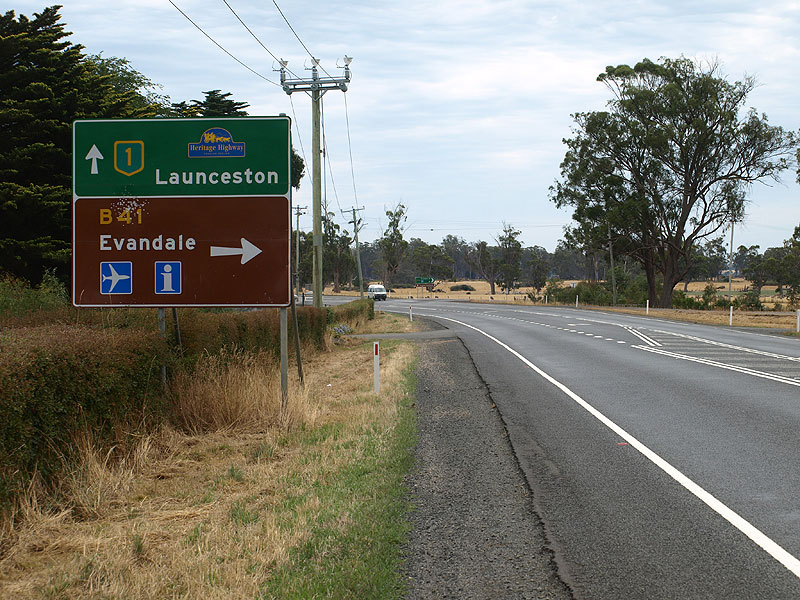
B41 is a short, 12km long, route in the northern Midlands of Tasmania, forming a loop to the east of National Highway Route 1 (Midland Highway) from south of Perth to the southern end of the Launceston Southern Outlet at Breadalbane. B41 is the principal access route between Midland Highway and Launceston Airport, from both the north and south ends. In addition, B41 is the major access road to the historic township of Evandale and the tourist destination of Clarendon Homestead.
B41 is fully sealed along its length and is constructed to a high standard. A pre-stressed concrete bridge over the South Esk River is provided on Leighlands Rd just north of Evandale, however the bridge is designed to be submersible in larger floods.
At its northern (Breadalbane) end, B41 (Evandale Rd) was deviated in 1987 to its current arrangement, meeting Midland Highway at a large-radius roundabout, as part of the Launceston Southern Outlet project. The original road alignment still exists, although severed at its southern end, as a local access road. It has been re-named Raeburn Rd and still joins Hobart Rd (C402 - formerly Midland Highway) at the junction where B41 and NHR1 met prior to 1987.
Details of the old alignment are covered on the Launceston Southern Outlet project page. (Coming Soon!)
|
Photos of route B41 |
|
 |
Midland Highway (NHR1) heading south towards Breadalbane - this is the first reference to the B41 junction, 1km further south. Source: Peter Renshaw, June 2007. |
 |
Midland Highway (NHR1) heading south towards Breadalbane - this is the second reference to the B41 junction. Note the use of a photograph on the sign - something not seen on the mainland and used sparingly in Tasmania. Also note that the loop (referring to the route of the B41) does not actually pass through Evandale, a little misleading. Source: Peter Renshaw, October 2012. |
  |
Old and new driving instruction AD sign southbound on Midland Highway (NHR1) approaching Breadalbane Roundabout. Through traffic must get in the right lane here to continue south along Midland Highway. Top photo: March 2009. Bottom photo: Peter Renshaw, October 2012 |
  |
Old and new tourist AD signs southbound on Midland Highway (NHR1) approaching the junction with B41 at Breadalbane. Top photo: Peter Renshaw, June 2007. Bottom photo: Peter Renshaw, October 2012. |
  |
Midland Highway (NHR1) southbound approaching the junction with Evandale Rd (B41) & Hobart Rd (C402) at Breadalbane. Top photo: Peter Renshaw, June 2007. Bottom photo: Peter Renshaw, October 2012. |
  |
Old and new AD signs on Hobart Rd (C402) south-westbound approaching the junction with Midland Hwy (NH1) & Evandale Rd (B41) at Breadalbane. Top photo: DIER, July 2003. Bottom photo: Peter Renshaw, October 2012. |
  |
Old and new tourist AD signs on Midland Hwy (NH1) north-westbound approaching the junction with Evandale Rd (B41) & Hobart Rd (C402) at Breadalbane. Top photo: Peter Renshaw, June 2007. Bottom photo: Peter Renshaw, October 2012. |
   |
Old, new and newer AD signs Midland Hwy (NH1) north-westbound approaching the junction with Evandale Rd (B41) & Hobart Rd (C402) at Breadalbane. The signs at this junction were replaced in 2009 and then this AD sign was replaced again when a slip lane was built in early 2012. The middle photo shows both the 2011 and 2012 AD signs in situ, just after the 2012 AD sign was installed. Top photo: Peter Renshaw, June 2007. Middle photo: Peter Renshaw, February 2012. Bottom photo: Peter Renshaw, October 2012. |
  |
Old and new ID signs pointing B41 traffic towards Evandale at the junction of Midland Hwy (NH1) & Evandale Rd (B41) & Hobart Rd (C402), Breadalbane. Top photo: Peter Renshaw, April 2007. Bottom: Peter Renshaw, October 2012. |
  |
Old and new AD signs on Evandale Rd (B41) northbound approaching the junction with Midland Hwy (NH1) & Hobart Rd (C402) at Breadalbane. Top photo: Peter Renshaw, April 2007. Bottom: Peter Renshaw, October 2012. |
|
Evandale Rd (B41) heading south from the junction with Midland Hwy (NH1) & Hobart Rd (C402) at Breadalbane. Source: Peter Renshaw, April 2007. |
 |
Evandale Rd (B41), looking south to the new roundabout at the intersection with Boral Drive at Launceston Airport. Note the plethora of tourist and service symbols on the sign - it would seem unlikely that a driver could take all that information in. Source: Peter Renshaw, November 2007. |
 |
Northbound ID sign at the intersection of Evandale Rd (B41) & Boral Dr, Launceston Airport. Note that Hobart is signed via Breadalbane, despite it being shorter to reach Hobart via Leighlands Rd (B41). Source: Peter Renshaw, November 2007. |
 |
Southbound ID sign at the intersection of Evandale Rd (B41) & Boral Dr, Launceston Airport. Source: Peter Renshaw, November 2007. |
 |
AD sign nothbound on Evandale Rd (B41) approaching the junction with Boral Dr at Launceston Airport. Source: Peter Renshaw, November 2007. |
 |
Evandale Rd (B41) looking north to Boral Dr, Launceston Airport. Recent development adjacent to the airport has seen the installation of two roundabouts to better cope with the conflicting traffic movements. Source: Peter Renshaw, November 2007. |
 |
Fingerboard signs at the junction of Evandale Rd (B41) & the entrance to Launceston Airport. Source: Peter Renshaw, November 2007. |
 |
Evandale Rd (B41) looking north to the Launceston Airport entrance. Source: Peter Renshaw, June 2007. |
 |
Evandale Rd (B41) looking south, approaching the junction with Mill Rd (C417) at Western Junction. C417 is a popular route for traffic between Launceston Airport and the north-west of the state as it links with B52 (Illawarra Rd) at Perth. Source: Peter Renshaw, April 2007. |
 |
Evandale Rd (B41) looking south to the junction with Mill Rd (C417) and the level crossings at Western Junction. Photo taken: March 2009. |
 |
Fingerboard signs at the junction of Evandale Rd (B41) & Mill Rd (C417), Western Junction. Behind the signs is a rather derelict looking goods yard at the junction of the Hobart to Launceston & Main Western (Launceston to Burnie) railway lines after which the locality is named. Source: Peter Renshaw, April 2007. |
 |
Evandale Rd (B41) northbound approaching the junction with Mill Rd (C417) at Western Junction. Source: Peter Renshaw, May 2007. |
 |
Evandale Rd (B41) looking south towards the junction with Leighlands Rd (B41). Note the absence of any AD sign for B41's right turn onto Leighlands Rd. Also note the level crossing of the Launceston to Burnie railway line at the bottom of the hill. Source: Peter Renshaw, November 2007. |
 |
Evandale Rd (B41) looking south to the junction with Leighlands Rd (B41). Evandale Rd continues southwards into Evandale as C416, becoming High St. There is no AD sign provided on this approach to the junction. Photo taken: March 2009. |
  |
Original 1980s fingerboard signs at the junction of Evandale Rd (B41/C416) & Leighlands Rd (B41), the northern terminus of C416. Photos taken: March 2009. |
 |
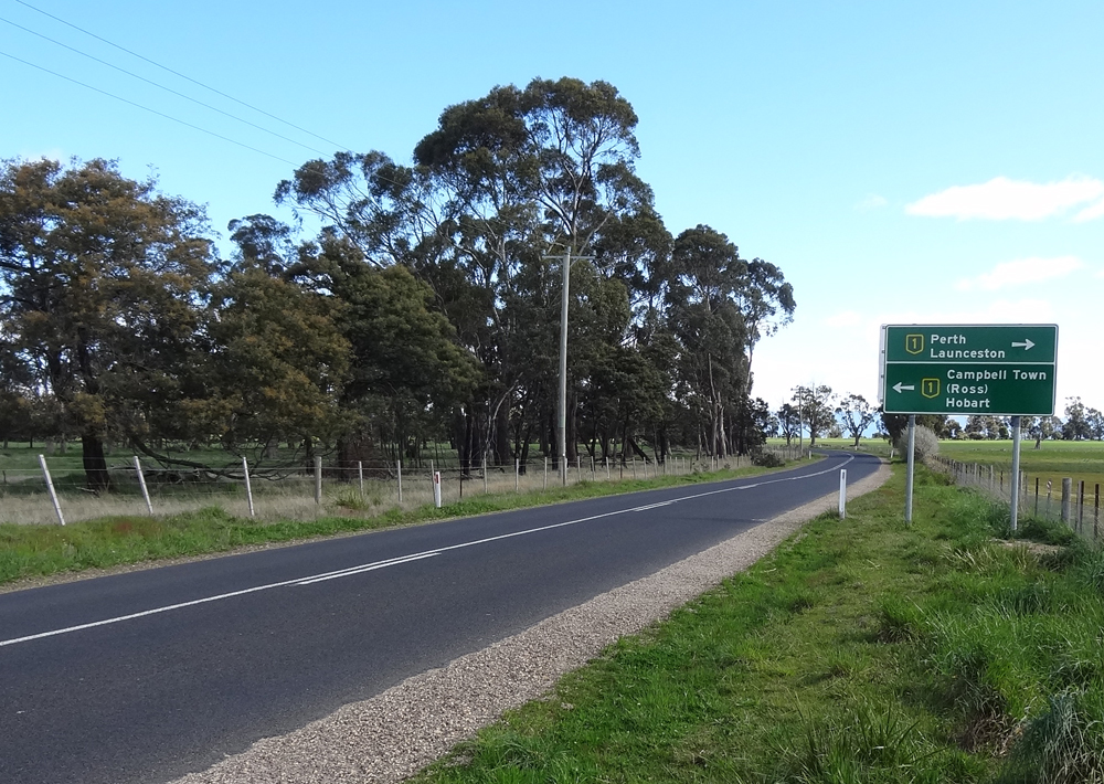
Brand new green ID signs installed in October 2012 to replace the original fingerboards at the junction of Evandale Rd (B41/C416) & Leighlands Rd (B41). Note the replacement of 'To NH1 SOUTH' with '(Campbell Town)' and the additional of Ben Lomond National Park as a focal point. Source: Peter Renshaw, October 2012. |
 |
Leighlands Rd (B41) looking west from the junction with Evandale Rd (B41/C416) just north of Evandale. A level crossing of the Hobart to Launceston railway line and the bridge over the South Esk River is in the middle distance. Source: Peter Renshaw, April 2007. |
 |
The bridge that carries Leighlands Rd (B41) across the South Esk River. Constructed in 1956, the bridge was originally designed to be submersed in large floods - the railings collapsing to allow debris to pass over the structure, however the installation of the footway with steel handrails may have compromised that. Source: Peter Renshaw, May 2007. |
  |
The top photo shows the original 1980s diagrammatic AD sign which was formerly located on Leighlands Rd (B41) approaching the junction with Evandale Rd (B41/C416) at Evandale.The bottom photo shows the standard stack AD sign which replaced it in October 2012. Top photo: March 2009. Bottom photo: Peter Renshaw, October 2012. |
 |
Leighlands Rd (B41) looking west from the bridge over the South Esk River. Source: Peter Renshaw, May 2007. |
 |
Leighlands Rd (B41) looking west approximately 500m from the entrance to the Tasmanian Sauce Company. Source: Peter Renshaw, November 2007. |
 |
Leighlands Rd (B41) looking east approximately 0.5km from the junction with Midland Highway (NH1). Source: Peter Renshaw, November 2007. |
  |
Old and new AD signs westbound on Leighlands Rd (B41) approaching the junction with Midland Hwy (NH1). Top photo: Peter Renshaw, November 2007. Bottom photo: Peter Renshaw, October 2012. |
  |
Old and new RD signs eastbound on Leighlands Rd (B41) after the junction with Midland Hwy (NH1). Top photo: Peter Renshaw, November 2007. Bottom photo: Peter Renshaw, October 2012. |
 |
AD sign northbound on Midland Hwy (NH1), 1km south of the junction with Leighlands Rd (B41). Source: Peter Renshaw, February 2008. |
 |
AD sign northbound on Midland Hwy (NH1) approaching the junction with Leighlands Rd (B41). Note that the sign is slightly misleading - Evandale is not actually on B41. Source: Peter Renshaw, February 2008. |
  |
Old and new tourist AD signs northbound on Midland Hwy (NH1), 400m south of the intersection with Leighlands Rd (B41). Top photo: Peter Renshaw, February 2008. Bottom photo: Peter Renshaw, October 2012. |
  |
Old and new AD signs northbound on Midland Hwy (NH1) - the final one before the junction with Leighlands Rd (B41). Note the unusual use of the brown background for the Evandale panel on the old AD sign - I suspect this might be an early (mid 1990s) prototype for improved tourist signposting in Tasmania. Top photo: Peter Renshaw, February 2008. Bottom photo: Peter Renshaw, October 2012. |
  |
Old and new tourist AD signs southbound on Midland Hwy (NH1) approaching the junction with Leighlands Rd (B41). Note the proliferation of tourist symbols on this sign - surely impossible to take in at 110km/h. Top photo: Peter Renshaw, February 2008. Bottom photo: Peter Renshaw, October 2012. |
  |
Old and new AD signs southbound on Midland Hwy (NH1) approaching the junction with Leighlands Rd (B41). Note the unusual use of the brown background for the Evandale panel on the old AD sign - I suspect this might be an early (mid 1990s) prototype for improved tourist signposting in Tasmania. Top photo: Peter Renshaw, February 2008. Bottom photo: Peter Renshaw, October 2012. |
  |
Old and new, green and brown fingerboard signs at the junction of Midland Hwy (NH1) & Leighlands Rd (B41), 4km south of Perth. Top photo: Peter Renshaw, May 2007. Bottom photo: Peter Renshaw, October 2012. |
 |
ID sign assembly facing B41 traffic at the intersection of Midland Hwy (NH1) & Leighlands Rd (B41), 4km south of Perth. Source: Peter Renshaw, February 2008. |
Last updated 8 December 2012 © Ozroads 2003-2012. |