Sidmouth to Rowella |

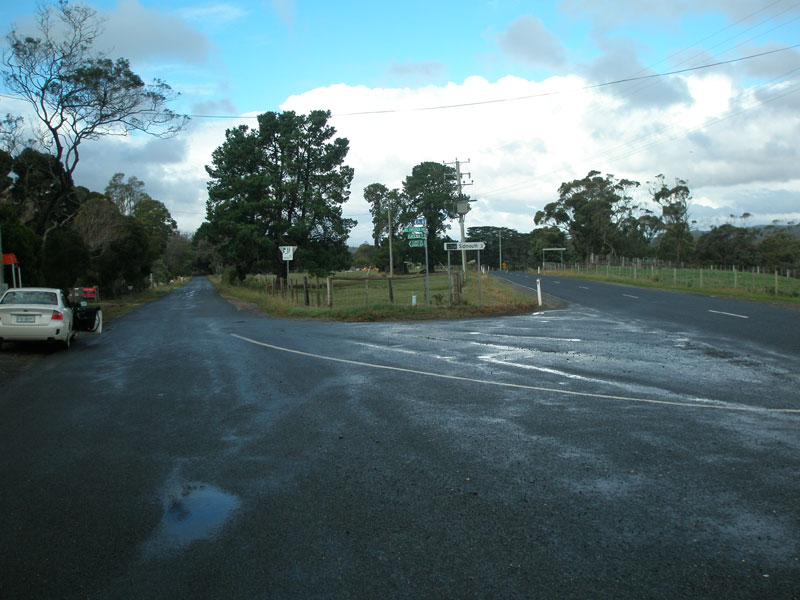
Fingerboard signs at the southern terminus of C724 - the junction with Batman Highway (B73), 1km west of Batman Bridge. Source: Peter Renshaw, May 2007.
Introduced: 1980
Length: 7km
Northern Terminus: Rowella (eastern end of West Bay Jetty Rd)
Southern Terminus: Batman Highway (B73) & Rowella Rd (C724), 1km west of Batman Bridge
Route taken: Rowella Rd, West Bay Jetty Rd
Focal Points: Sidmouth, Kayena, Rowella
Responsibility: Local Government
Route C724 is a minor rural route in northern Tasmania, branching from the Batman Highway (B73) on the western side of Batman Bridge and serving a rich wine-growing area alongside the Tamar River. The route is fully sealed and ends right on the Tamar River at Rowella.
|
Photos of route C724 |
|
 |
AD sign westbound on Batman Highway (B73) approaching the junction with Rowella Rd (C724). Source: Peter Renshaw, May 2007. |
|
Fingerboard signs at the southern terminus of C724 - the junction of Batman Highway (B73) & Rowella Rd (C724), 1km west of Batman Bridge. Source: Peter Renshaw, May 2007. |
 |
Other side of the fingerboard signs at the southern terminus of C724 - the junction of Batman Highway (B73) & Rowella Rd (C724), 1km west of Batman Bridge. Source: Peter Renshaw, May 2007. |
 |
Rowella Rd (C724) looking north from Batman Highway. Source: Peter Renshaw, May 2007. |
 |
Fingerboard sign facing southbound C724 traffic at the junction with Auld Kirk Rd, 1km north of Batman Highway. Source: Peter Renshaw, May 2007. |
 |
View south from C724 (Rowella Rd) over the Tamar River towards Batman Bridge, south of Kayena. Source: Peter Renshaw, May 2007. |
 |
Looking south through beautiful countryside south of Kayena, with Devil's Elbow Reach of the Tamar River on the left. Source: Peter Renshaw, May 2007. |
 |
Looking south at the intersection of Rowella Rd (C724) & Kayena Rd in Kayena. Source: Peter Renshaw, May 2007. |
 |
Fingerboard sign at the intersection of Rowella Rd (C724) & Kayena Rd in Kayena, pointing southbound traffic towards the Batman Highway. Source: Peter Renshaw, May 2007. |
 |
Rowella Rd (C724), looking south from the junction with Auburn Rd in Kayena. Source: Peter Renshaw, May 2007. |
  |
Fingerboard signs at the intersection of Rowella Rd (C724) & Auburn Rd, Kayena. The fingerboards in the above photo were replaced by this travesty in early 2010. Requests to West Tamar Council to fix the right-pointing fingerboard have not yet yielded a result. |
 |
Rowella Rd (C724) looking north from Auburn Rd towards Rowella Hall - located in the clump of trees, top left of photo. Source: Peter Renshaw, May 2007. |
 |
Rowella Rd (C724) looking south from Rowella Hall towards Kayena. Source: Peter Renshaw, May 2007. |
Nineteenth century milestone adjacent to Rowella Rd (C724) outside Rowella Hall (in background). 'R' refers to Rowella. Source: Peter Renshaw, May 2007. |
|
The other side of the nineteenth century milestone adjacent to Rowella Rd (C724). 'L' refers to Launceston. Source: Peter Renshaw, May 2007. |
|
 |
Rowella Rd (C724) looking north from Rowella Hall. Source: Peter Renshaw, May 2007. |
 |
North of Rowella Hall, Rowella Rd and C724 make a 90 degree turn to the east at the intersection with Westwoods Rd & Blackwood Hills Rd. This fingerboard sign faces northbound traffic. Source: Peter Renshaw, May 2007. |
 |
Fingerboard sign facing southbound C724 traffic at the intersection of Rowella Rd (C724), Westwoods Rd & Blackwood Hills Rd. Source: Peter Renshaw, May 2007. |
 |
The last 2km of C724 are dead straight - this view is looking east towards the Tamar River from Westwoods Rd. Source: Peter Renshaw, May 2007. |
 |
Looking west at the end of Rowella Rd - ends at the intersection in the foreground. C724 continues east as a gravel road - the beginnings of which are visible in the foreground of the photo - behind the camera before ending at Holm Oaks Vineyard on the Tamar River bank. Source: Peter Renshaw, May 2007. |
Last updated 30 March 2011 © Ozroads 2004-2011. |