Deloraine - Osmaston - Westbury |

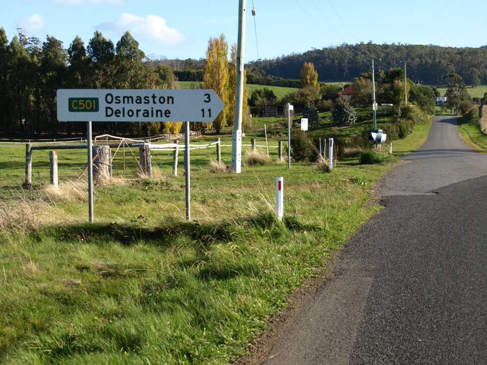
Old and new fingerboard signs at the intersection of Quamby Brook Rd (C501/C503) & Osmaston Rd (C501). Source: Peter Renshaw, June 2007.
Introduced: 1980
Length: 20km
Eastern Terminus: Meander Valley Secondary Rd (B54) & William St (B72/C501), Westbury
Western Terminus: Lake Secondary Rd (A5) & Barrack St (C501), Deloraine
Route taken: William St, Dexter St, Mary St, Osmaston Rd, Quamby Brook Rd, Barrack St
Focal Points: Westbury, Osmaston, Deloraine
Responsibility: Local Government
C501 is a rural route in the Meander River valley, west of Launceston, forming a loop between Westbury and Deloraine. It serves a rich agricultural district, as well as forming part of a tourist route between Westbury and Liffey Falls. It is sealed for its entire length and also mostly devoid of line markings.
|
Photos of route C501 |
|
 |
William St (B72) southbound approaching Meander Valley Secondary Rd (B54) & William St (C501) at Westbury. Source: Peter Renshaw, June 2007. |
 |
Meander Valley Secondary Rd (B54) westbound approaching William St (B72/C501) at Westbury.
Source: Peter Renshaw, June 2007. |
 |
Meander Valley Secondary Rd (B54) eastbound approaching William St (/B72C501) at Westbury. Source: Peter Renshaw, August 2007. |
 |
Fingerboard sign pointing traffic along the beginning of C501 (William St) in Westbury. This sign has since been removed by Meander Valley Council without replacement as apparently it does not fit within the historic streetscape. An epic fail for navigation! Source: Peter Renshaw, June 2007. |
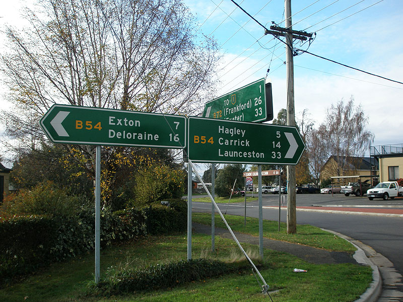 |
Fingerboard signs at the intersection of Meander Valley Secondary Rd (B54) & William St (B72/C501), Westbury. Source: Peter Renshaw, June 2007. |
  |
Two views of William St (C501), looking south through the village of Westbury. The bottom photo shows the entry statements erected by Meander Valley Council in 2009. Top photo: Peter Renshaw, June 2007 Bottom photo: Peter Renshaw, April 2010. |
 |
Looking north along William St (C501) through the village of Westbury. Source: Peter Renshaw, May 2010. |
 |
Looking south along William St (C501) at King St, Westbury. Note that the brown direction sign for Liffey Falls directs traffic via King St instead of following C501, for some strange reason. Source: Peter Renshaw, May 2010. |
 |
Looking north along William St (C501) from the Dexter St (C501) intersection at Westbury. Source: Peter Renshaw, June 2007. |
  |
Deteriorating fingerboard at the intersection of Dexter St (C501) & William St (C501), Westbury. Note that the NH1 shield dates from prior to the opening of the Westbury Bypass and refers to what is now Meander Valley Secondary Rd (B54). Top photo : Peter Renshaw, June 2007. Bottom photo: Peter Renshaw, April 2009. |
 |
Replacement fingerboard sign facing eastbound/northbound traffic at the intersection of Dexter St (C501) & William St (C501), Westbury. Note that the 'To NH1' has not been updated to reflect the change of route marker/additional distance to the relocated NH1! Source: Peter Renshaw, May 2010. |
  |
Two photos showing the original, deteriorating fingerboard sign facing southbound traffic at the intersection of Dexter St (C501) & William St (C501), Westbury. Top photo : Peter Renshaw, June 2007. Bottom photo: Peter Renshaw, April 2009. |
 |
Replacement fingerboard sign facing southbound traffic at the intersection of Dexter St (C501) & William St (C501), Westbury. Source: Peter Renshaw, May 2010. |
 |
Dexter St (C501) looking west from William St (C501), Westbury. Source: Peter Renshaw, May 2010. |
  |
Original and replacement fingerboard signs at the intersection of Dexter St (C501) & Mary St (C501), Westbury. The NH1 shield on the original sign dates from prior to the opening of the Westbury Bypass and refers to what is now Meander Valley Secondary Rd (B54). Note how this was not corrected (either via changing the distance to 2km, or the route marker to B54) when the sign was replaced! Top photo: Peter Renshaw, June 2007. Bottom photo: Peter Renshaw, May 2010. |
  |
Original and replacement fingerboard sigsn at the intersection of Dexter St (C501) & Mary St (C501), Westbury. Note that the signage for Liffey Falls is not followed up along the route. Top photo: Peter Renshaw, June 2007. Bottom photo: Peter Renshaw, May 2010. |
 |
Mary St (C501) looking south on the southern outskirts of Westbury as it transitiions into Osmaston Rd. Source: Peter Renshaw, June 2007. |
 |
Osmaston Rd (C501) looking south-west as it swings around to the west and Quamby Bluff comes into view. Source: Peter Renshaw, June 2007. |
 |
Osmaston Rd (C501) looking south-west towards the intersection with Cluan Rd (C505), 6km south of Westbury. Source: Peter Renshaw, June 2007. |
 |
Osmaston Rd (C501) looking south-west at the intersection with Cluan Rd (C505), 6km south of Westbury. Source: Peter Renshaw, June 2007. |
 |
Fingerboard signs at the intersection of Osmaston Rd (C501) & Cluan Rd (C505), 6km south of Westbury. Source: Peter Renshaw, June 2007. |
 |
Osmaston Rd (C501) looking west to a single-lane bridge over Quamby Brook, near the intersection with Cluan Rd (C505). Source: Peter Renshaw, November 2007. |
 |
Osmaston Rd (C501) looking east to the single-lane bridge over Quamby Brook, near the intersection with Cluan Rd (C505). Source: Peter Renshaw, June 2007. |
 |
Osmaston Rd (C501) looking south-west towards the intersection with Fern Bank Rd, 3km east of Osmaston. Source: Peter Renshaw, November 2007. |
  |
Original and replacement fingerboard signs facing westbound traffic at the intersection of Osmaston Rd (C501) & Fern Bank Rd, 3km east of Osmaston. The replacement sign was manufactured in June 2009; the original sign was probably installed circa 1982. Top photo : Peter Renshaw, June 2007. Bottom photo: Peter Renshaw, May 2010. |
 |
Osmaston Rd (C501) looking east from Osmaston. Source: Peter Renshaw, June 2007. |
 |
Osmaston Rd (C501) looking east near Osmaston. Source: Peter Renshaw, November 2007. |
|
Top: Poorly located fingerboard signs facing C502 traffic at the intersection of Osmaston Rd (C501), Exton Rd (C502) & Bogan Rd (C502), Osmaston. Source: Peter Renshaw, June 2007. Bottom: Renewed fingerboard signs facing southbound C502 traffic at the intersection of Osmaston Rd (C501), Exton Rd (C502) & Bogan Rd (C502), Osmaston. Source: Peter Renshaw, September 2008. |
 |
The other side of the poorly located fingerboards at the intersection of Osmaston Rd (C501) & Exton Rd (C502) & Bogan Rd (C502), Osmaston. Source: Peter Renshaw, June 2007. |
 |
Osmaston Rd (C501) looking east at the intersection with Exton Rd (C502) & Bogan Rd (C502), Osmaston. Source: Peter Renshaw, June 2007. |
 |
Osmaston Rd (C501) looking east at the small bridge over Quamby Brook, just west of the junction with Exton Rd (C502). Source: Peter Renshaw, May 2010. |
 |
Osmaston Rd (C501) looking east from the intersection with Quamby Brook Rd (C501/C503), 3km south of Deloraine. Source: Peter Renshaw, June 2007. |
 |
Fingerboard sign at the intersection of Osmaston Rd (C501) & Quamby Brook Rd (C501/C503), 3km south of Deloraine. Source: Peter Renshaw, June 2007. |
 |
Top: Old and new fingerboard signs at the intersection of Osmaston Rd (C501) & Quamby Brook Rd (C501/C503), 3km south of Deloraine. Source: Peter Renshaw, June 2007. Bottom: Renewed C501 fingerboard at the intersection of Osmaston Rd (C501) & Quamby Brook Road (C501/C503), 3km south of Deloraine. Source: Peter Renshaw, September 2008. |
 |
Quamby Brook Rd (C501) looking south at the intersection with Osmaston Rd (C501), which goes to the left. Quamby Brook Rd continues straight as C503. Source: Peter Renshaw, June 2007. |
 |
Quamby Brook Rd (C501) looking south approximately 2km south of Deloraine. Source: Peter Renshaw, June 2007. |
 |
Barrack St (C501) looking south-east from the intersection with Lake Secondary Rd (A5) at Deloraine. Source: Peter Renshaw, June 2007. |
 |
Fingerboard signs at the intersection of Lake Secondary Rd (A5) & Barrack St (C501), Deloraine. Source: Peter Renshaw, June 2007. |
 |
Lake Secondary Rd (A5) northbound approaching the intersection with Barrack St (C501), Deloraine. Source: Peter Renshaw, June 2007. |


Last updated 15 May 2011 © Ozroads 2004-2011. |