Gladstone - Ansons Bay - St Helens |

Fingerboard signs at the junction of Tasman Hwy (A3) & Ansons Bay Rd (C843), 3km north of St Helens. Source: Peter Renshaw, April 2008.
Introduced: 1980
Length: 65km
Northern Terminus: Gladstone Main Rd (B82), Waterhouse Rd (B82) & Carr St (C843), Gladstone
Southern Terminus: Tasman Highway (A3) & Ansons Bay Rd (C843), 3km north of St Helens
Route taken: Carr St, Browns Bridge Rd, Eddystone Rd, Ansons Bay Rd
Focal Points: Gladstone, (Mt William National Park), Ansons Bay, Priory, St Helens
Responsibility: Local Government
C843 is a 65km long route in north eastern Tasmania, linking the Tasman Highway at St Helens with route B82 at Gladstone. Mostly unsealed, narrow and with long winding sections, it is rarely used as a through route. Its main purpose is to provide access to the popular holiday spots of Ansons Bay, Eddystone Point and the remote areas at the north eastern tip of the island.
Commencing at Gladstone, the sealed road extends eastwards for 10km, linking with roads leading to Little Musselroe Bay, Musselroe Bay and Mt William National Park. The route is then largely unsealed for the rest of the journey, including a two very narrow and winding sections either side of the low-level crossing of Ansons River. Approximately 10km north of St Helens the sealed pavement returns, serving farming and rural residential areas between Priory and St Helens.
Recent improvements to the route include the construction of new bridges over the Ringarooma River at Gladstone and the Great Musselroe River at Browns Bridge.
Notable Events:
2008 - Replacement of timber beam bridge over Great Musselroe River
|
Photos of route C843 |
|
 |
AD sign eastbound on Waterhouse Rd (B82), approaching the junction with Gladstone Main Rd (B82) & Carr St (C843), Gladstone. |
 |
AD sign northbound on Gladstone Main Rd (B82) approaching the junction with Waterhouse Rd (B82) & Carr St (C843). Note the absence of any mention of route B82 which turns left at this intersection. |
 |
Ageing fingerboards facing northbound traffic at the intersection of Gladstone Main Rd (B82), Waterhouse Rd (B82) & Carr St (C843), Gladstone. |
 |
Carr St (C843) looking west towards the junction with Gladstone Main Rd (B82) & Waterhouse Rd (B82), Gladstone. |
 |
Browns Bridge Rd (C843) looking southwest into Gladstone. Source: Peter Renshaw, October 2007. |
 |
Browns Bridge Rd (C8430 looking east across the bridge over the Ringarooma River, 1km east of Gladstone. Source: Peter Renshaw, October 2007. |
| Fingerboard sign assembly at the intersection of Browns Bridge Rd (C843) & Cape Portland Rd (C844), 2km east of Gladstone. There is no fingerboard sign pointing traffic towards Gladstone. | |
 |
Browns Bridge Rd (C843) looking west towards the intersection with Cape Portland Rd (C844), 2km east of Gladstone. Note the absence of a fingerboard sign to guide traffic towards Gladstone. Source: Peter Renshaw, October 2007. |
 |
Browns Bridge Rd (C843) looking east across the historic Mt Cameron Water Race, 5km east of Gladstone. Source: Peter Renshaw, October 2007. |
 |
Browns Bridge Rd (C843) looking east across the plains towards the Great Musselroe River, 7km east of Gladstone. Source: Peter Renshaw, October 2007. |
Two views looking west across Browns Bridge over the Great Musselroe River, 9km east of Gladstone. The first photo shows the old timber beam bridge and the second photo shows the replacement concrete structure approaching completion. Top photo: Peter Renshaw, October 2007. Bottom photo: Peter Renshaw, April 2008. |
|
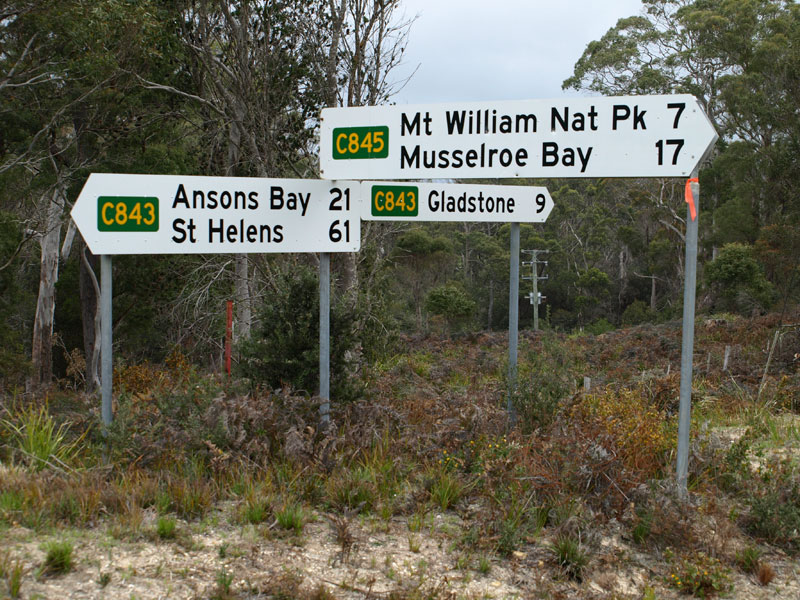 |
Fingerboard sign assembly at the intersection of Browns Bridge Rd (C843), Eddystone Rd (C843) & Musselroe Rd (C845), 9km east of Gladstone. Source: Peter Renshaw, October 2007. |
 |
Eddystone Rd (C843) looking east near the junction with Musselroe Rd (C845) showing signage denoting the boundary of Dorset and Break O'Day local government areas. Bottom photo: Peter Renshaw, October 2007. |
 |
Eddystone Rd (C843) looking east towards the end of the sealed road, 10km east of Gladstone. Source: Peter Renshaw, April 2008. |
 |
Eddystone Rd (C843) looking east through fertile farmland, 11km east of Gladstone. Source: Peter Renshaw, April 2008. |
 |
Eddystone Rd (C843) looking south through the Boggy Creek area, 19km east of Gladstone. Source: Peter Renshaw, April 2008. |
 |
Eddystone Rd (C843) looking northwest towards Mt Cameron and the Sugar Loaves, 20km east of Gladstone.
Source: Peter Renshaw, April 2008. |
 |
Eddystone Rd (C843) looking east to the boundary of Mt William National Park, 22km east of Gladstone. Source: Peter Renshaw, April 2008. |
 |
Eddystone Rd (C843) looking south towards the junction with Ansons Bay Rd (C843). Eddystone Rd branches off to the left as C846, whilst C843 continues straight ahead as Ansons Bay Rd. Source: Peter Renshaw, April 2008. |
 |
Fingerboard sign assembly at the intersection of Eddystone Rd (C843/C846) & Ansons Bay Rd (C843), 27km south east of Gladstone.
Source: Peter Renshaw, April 2008. |
 |
Just beyond the intersection above, Ansons Bay Rd (C843) turns southwards to bypass Ansons Bay. North Ansons Rd continues straight to provide access to the tiny fishing and holiday village. This photograph shows the fingerboard sign assembly at the intersection of Ansons Bay Rd (C843) & North Ansons Rd. Source: Peter Renshaw, April 2008. |
 |
Ansons Bay Rd (C843) looking north, approximately 1km south of North Ansons Rd. Source: Peter Renshaw, April 2008. |
Two southbound photos showing Ansons Bay Rd (C843) as it descends towards the low-level crossing of the Ansons River. Source: Peter Renshaw, April 2008. |
|
 |
Ansons Bay Rd (C843) southbound approaching the causeway across the Ansons River. Source: Peter Renshaw, April 2008. |
 |
Looking south across the causeway at Ansons River, 39km north of St Helens. Source: Peter Renshaw, April 2008. |
Ansons Bay Rd (C843) looking north on the southern descent to the Ansons River crossing. Source: Peter Renshaw, April 2008. |
|
Fingerboard signs at the intersection of Ansons Bay Rd (C843) & South Ansons Rd, 1km south of Ansons River. South Ansons Rd leads along the southern shore of Ansons Bay to Policemans Point. Source: Peter Renshaw, April 2008. |
|
 |
Ansons Bay Rd (C843) looking north towards the intersection with South Ansons Rd, 1km south of Ansons River. C843 makes a left turn before descending to the low-level crossing of the Ansons River. |
 |
Ansons Bay Rd (C843) looking south through the state forest, 4km south of Ansons River. Source: Peter Renshaw, April 2008. |
 |
Ansons Bay Rd (C843) looking south through the forest, 8km south of Ansons River. |
 |
Ansons Bay Rd (C843) looking south near Pattersons Hill as the forest makes way for undulating farmland in the Ansons River valley. Source: Peter Renshaw, April 2008. |
 |
Ansons Bay Rd (C843) looking south across the Last River, 29km north of St Helens. Source: Peter Renshaw, April 2008. |
 |
Ansons Bay Rd (C843) looking south approximately 25km north of St Helens. Source: Peter Renshaw, April 2008. |
 |
Ansons Bay Rd (C843) looking south across Dead Horse Creek, 21km north of St Helens. Source: Peter Renshaw, April 2008. |
 |
Ansons Bay Rd (C843) looking south, 17km north of St Helens. Source: Peter Renshaw, April 2008. |
 |
Ansons Bay Rd (C843) looking north, 13km north of St Helens. Note the short sealed section. Source: Peter Renshaw, April 2008. |
 |
Ansons Bay Rd (C843) looking north across Bosses Creek, 11km north of St Helens. Source: Peter Renshaw, April 2008. |
 |
Ansons Bay Rd (C843) looking south near the start of the sealed road, 9km north of St Helens. Source: Peter Renshaw, April 2008. |
 |
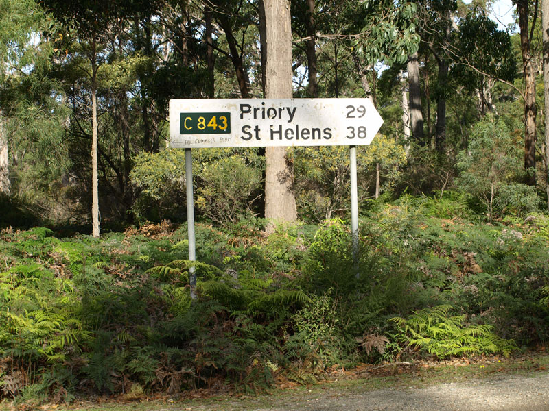
Ansons Bay Rd (C843) looking south at the locality of Priory, 8km north of St Helens. The bridge in the middle ground crosses the George River. Source: Peter Renshaw, April 2008. |
 |
Ansons Bay Rd (C843) looking north at Priority, showing the timber beam bridge across the George River. Source: Peter Renshaw, April 2008. |
 |
Ansons Bay Rd (C843) looking south, approximately 6km north of St Helens. Source: Peter Renshaw, April 2008. |
Fingerboard signs at the intersection of Ansons Bay Rd (C843) & Reids Rd (C849), 4km north of St Helens. Reids Rd (C849) provides a short-cut from C843 across to the coast at Binalong Bay. Source: Peter Renshaw, April 2008. |
|
 |
Ansons Bay Rd (C843) looking south, approximately 3km north of St Helens. Source: Peter Renshaw, April 2008. |
 |
Ansons Bay Rd (C843) looking south near Reservoir Rd. Source: Peter Renshaw, April 2008. |
 |
Ansons Bay Rd (C843) looking south towards the junction with Tasman Hwy (A3), 3km north of St Helens - the southern terminus of the route. Source: Peter Renshaw, April 2008. |
 |
Fingerboard signs at the junction of Tasman Hwy (A3) & Ansons Bay Rd (C843), 3km north of St Helens. Source: Peter Renshaw, April 2008. |
 |
AD sign westbound on Tasman Hwy (A3) approaching the junction with Ansons Bay Rd (C843), 3km north of St Helens. Source: Peter Renshaw, November 2007. |
 |
AD sign eastbound on Tasman Hwy (A3) approaching the junction with Ansons Bay Rd (C843), 3km north of St Helens. |


Last updated 18 April 2011 © Ozroads 2004-2011. |