BATMAN HIGHWAY |

B73 (Batman Highway) looking west at Batman Bridge, which crosses the Tamar River approximately 35km north of Launceston. Source: Peter Renshaw, May 2007.
Length: 10km
Eastern Terminus: East Tamar Highway (A8), 19km south of George Town
Western Terminus: West Tamar Highway (A8), 10km north of Exeter
Route taken: Batman Highway
Focal Points: George Town, Beaconsfield/Exeter/Launceston
Route B73 introduced: 1980
Batman Highway proclaimed:
Batman Bridge opened: 18 May 1968
Responsibility: State Government
Batman Highway:
Batman Highway is a two-lane, undivided east-west highway in Tasmania's north, linking the East and West Tamar Highways via the Batman Bridge. The Batman Highway provides the only crossing of the Tamar River north of Launceston and serves traffic from the West Tamar to the port at Bell Bay.
Route B73:
Route B73 is an east-west route in northern Tasmania, utilising Batman Highway and the Batman Bridge to connect the East and West Tamar Highways. It was officially intrdouced in 1979 and, judging by the age of some signs along the route, signs were erected not long afterwards. There have been no changes to the route since its inception.
Route B73 provides the only vehicle crossing of the Tamar River north of Launceston and is thus heavily utilised - traffic volumes peak at 2,013 vehicles per day (2003) at the Batman Bridge.
During July 2008, the junction with Spring Hill Main Rd (C725) was reconstructed to give priority to B73 traffic. Prior to this, traffic from Exeter gave way to between Spring Hill Main Rd and Batman Bridge.
Batman Bridge: Info coming soon...
East Tamar Highway junction: Info coming soon...
References:
GHD. (2006). Gunns Limited Northern Tasmania Pulp Mill - Transport and Traffic Assessment Report. Prepared for Gunns Limited by GHD.
|
Photos of route B73/Batman Highway |
|
 |
AD sign northbound on West Tamar Highway approaching the Batman Highway junction. Note the parenthesis for Batman Highway's focal points - none of the destinations cited are located along the route. This reflects the route's primary role of connecting two other highways. Source: Peter Renshaw, April 2007. |
 |
Fingerboard signs at the junction of West Tamar and Batman Highways. The green fingerboards are used at the major rural junctions in Tasmania, as opposed to the usual white fingerboards that are used at minor rural junctions. Source: Peter Renshaw, July 2007. |
 |
Batman Highway (B73) looking east from the junction with West Tamar Highway (A7). Source: Peter Renshaw, July 2007. |
 |
Batman Highway looking south-west approaching West Tamar Highway. Source: Peter Renshaw, May 2007. |
  |
Top: AD sign eastbound on Spring Hill Main Rd (C725) approaching the junction with Batman Highway (B73). Bottom: AD sign eastbound on Spring Hill Main Rd (C725) approaching the reconstructed junction with Batman Highway (B73). |
|
Fingerboard signs at the junction of Batman Highway and Spring Hill Main Rd (C725). Spring Hill Main Rd provides a short cut between Batman and West Tamar Highways for traffic heading to/from the north. |
 |
Fingerboard signs at the reconstructed junction of Batman Highway & Spring Hill Main Rd (C725). Source: Peter Renshaw, October 2008. |
 |
Batman Highway looking east from the junction with Spring Hill Main Rd (C725). Source: Peter Renshaw, May 2007. |
 |
AD sign westbound on Batman Highway approaching the junction with Spring Hill Main Rd (C725). Source: Peter Renshaw, June 2008. |
 |
New AD sign westbound on Batman Highway (B73) approaching the reconstructed junction with Spring Hill Main Rd (C725). Note how the old AD sign has remained in situ closer to the crest in the distance. Source: Peter Renshaw, October 2008. |
 |
Batman Highway, looking west from Sidmouth. The junction with Spring Hill Main Rd (C725) is located at the top of the hill in the distance. Source: Peter Renshaw, May 2007. |
 |
Batman Highway looking east at the tiny locality of Sidmouth. Source: Peter Renshaw, May 2007. |
 |
Batman Highway looking east at the tiny locality of Sidmouth. Source: Peter Renshaw, May 2007. |
 |
Batman Highway looking east from Sidmouth Community Hall. Source: Peter Renshaw, October 2007. |
 |
Fingerboard signs at the junction of Batman Highway & Rowella Rd (C724). Note the use of parenthesis and route marker on which the destination is located - the use of route markers inside the parenthesis appears to be somewhat inconsistent across the state. Source: Peter Renshaw, May 2007. |
 |
AD sign westbound on Batman Highway approaching the junction with Rowella Rd (C724). Source: Peter Renshaw, May 2007. |
 |
Typical Tasmanian AD sign, eastbound on Batman Highway approaching Deviot Rd (C728). These signs are used for some minor rural junctions, typically where there may be less than desirable sight distance on the approach. Through destinations are usually only shown on AD signs at major rural junctions. Source: Peter Renshaw, May 2007. |
 |
Batman Highway looking west at the intersection with Deviot Rd (C728). Source: Peter Renshaw, May 2007. |
 |
Fingerboard signs at the junction with Deviot Rd (C728). Note the 'Batman Bridge' sign in the background. Source: Peter Renshaw, May 2007. |
Batman Highway looking east from Deviot Rd (C728) towards Batman Bridge. Source: Peter Renshaw, May 2007. |
|
 |
A side-on view of Batman Bridge from the north - taken along Auld Kirk Rd. Source: Peter Renshaw, May 2007. |
An eastbound view of the underside of the Batman Bridge, showing the steel deck and sloping A-frame which supports the bridge deck. Source: Peter Renshaw, May 2007. |
|
|
Looking west to Batman Bridge from the eastern bank of the Tamar River. Source: Peter Renshaw, May 2007. |
 |
Batman Highway looking west to Batman Bridge. A 70km/h speed limit for heavy vehicles is imposed across the bridge. Source: Peter Renshaw, May 2007. |
 |
Batman Highway looking west towards Batman Bridge - this is the first glimpse of the bridge for westbound traffic. Source: Peter Renshaw, May 2007. |
 |
Batman Highway looking west from the junction with Craigburn Rd (C727). Source: Peter Renshaw, May 2007. |
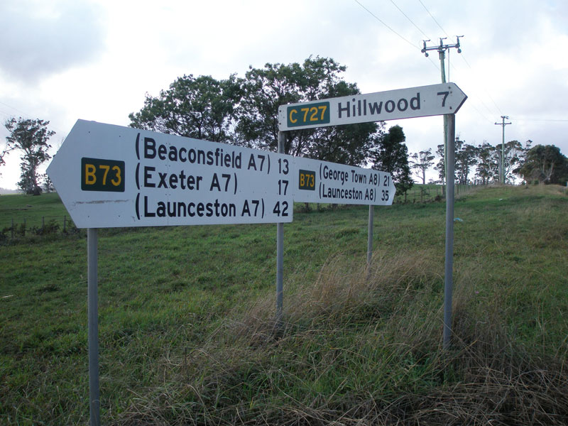 |
Fingerboard signs at the junction with Craigburn Rd (C727), 2km west of the East Tamar Highway. Source: Peter Renshaw, May 2007. |
 |
AD sign westbound on Batman Highway (B73) approaching Craigburn Rd (C727). Source: Peter Renshaw, June 2007. |
 |
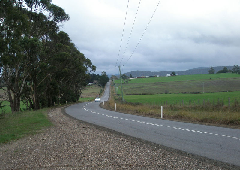
Batman Highway looking east between Craigburn Rd and East Tamar Highway. Source: Peter Renshaw, May 2007. |
 |
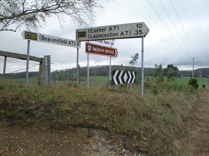
Distance sign on Batman Highway (B73), heading west from the junction with East Tamar Highway. Source: Peter Renshaw, October 2008. |
 |
Newly-installed Auslink project sign advising of the $60 million upgrade of the East Tamar Highway which will involve the construction of a grade-separated trumpet interchange at the junction with Batman Highway, due for completion in 2010. Source: Peter Renshaw, May 2007. |
 |
Batman Highway looking east to the junction with East Tamar Highway. This diagrammatic AD sign is one of the few remaining signs from the original rollout of alpha-numeric signage in the early 1980s. Source: Peter Renshaw, May 2007. |
 |
A southerly view of the Batman Highway/East Tamar Highway intersection which will soon be grade-separated. Note that Bell Bay is in parenthesis, despite lying only 1km off the East Tamar Highway. Source: Peter Renshaw, May 2007. |
 |
A close-up of the fingerboard sign facing southbound traffic at the Batman Highway/East Tamar Highway junction. Note the truck that can't stay in its lane - truck traffic is one of the hates of locals in the Tamar Valley because of this. Source: Peter Renshaw, May 2007. |
 |
East Tamar Highway southbound approaching the junction with Batman Highway. The road coming in from the left is Valley Rd (C810). Source: Peter Renshaw, May 2007. |
 |
Northbound AD sign on East Tamar Highway approaching the junction with Batman Highway. This appears to be suitable for incorporation into the ultimate grade-separated interchange. Source: Peter Renshaw, October 2008. |
Last updated 30 January 2009 © Ozroads 2004-2009. |