HAGLEY to BRACKNELL |

Fingerboard sign assembly at the intersection of Hagley Station Lane (C507) & Black Hills Rd (C507), 5km south of Hagley. Source: Peter Renshaw, October 2007.
Introduced: 1980
Length: 13km
Northern Terminus: Meander Valley Secondary Rd (B54) & Hagley Station Ln (C507), 1km east of Hagley
Southern Terminus: Oaks Rd (C511) & Whitemore Rd (C507), 5km north of Bracknell
Route taken: Hagley Station Rd, Black Hills Rd, Whitemore Rd
Focal Points: Hagley, "To NH1", (Whitemore), Glenore, (Bracknell)
Responsibility: Local Government
C507 is a rural route in the Meander valley area, west of Launceston, serving a rich agricultural district. It is sealed for its entire length and also mostly devoid of line markings. The northern-most kilometre of the route serves as a link between the Bass Highway (NH1) and Meander Valley Secondary Rd (B54 - former Bass Highway) at Hagley.
Focal point signage along this route is confusing, with the focal points having changed multiple times over the years but never comprehensively re-signed. Delineation of the route number, however, is acceptable, with the exception of the intersection with Adelphi Rd (C510).
|
Photos of route C507 |
|
 |
Meander Valley Secondary Rd (B54) eastbound approaching the junction with Hagley Station Lane (C507), 1km east of Hagley. The extensive signage at this intersection is unusual for a C route, existing due to the route's function as a link with Bass Highway (NH1). Source: Peter Renshaw, July 2007. |
 |
Meander Valley Secondary Rd (B54) westbound approaching the junction with Hagley Station Lane (C507), 1km east of Hagley. Source: Peter Renshaw, April 2007. |
 |
ID signage pointing C507 traffic south from the intersection of Meander Valley Secondary Rd (B54) & Hagley Station Lane (C507), 1km east of Hagley. Source: Peter Renshaw, July 2007. |
 |
Hagley Station Lane (C507) northbound approaching the junction with Meander Valley Secondary Rd (B54) near Hagley. Source: Peter Renshaw, June 2007. |
 |
Hagley Station Lane (C507) heading south from the intersection with Meander Valley Secondary Rd (B54). Reassurance Direction (RD) signs are unusual on C routes in Tasmania - this one exists due to the route's significance as a link to Bass Highway (NH1). Source: Peter Renshaw, July 2007. |
 |
Hagley Station Lane (C507) looking south approaching the junction with Bass Highway (NH1) near Hagley. Bass Highway (NH1) passes below Hagley Station Lane (C507) at this grade-separated interchange. Source: Peter Renshaw, July 2007. |
 |
Advance Direction (AD) signage on Bass Highway (NH1) westbound approaching the junction with Hagley Station Lane (C507). Source: Peter Renshaw, June 2007. |
 |
AD signage westbound on Bass Highway (NH1) approaching the junction with Hagley Station Lane (C507) near Hagley. Source: Peter Renshaw, October 2007. |
 |
Westbound exit signage at the junction of Bass Highway (NH1) & Hagley Station Lane (C507) near Hagley. Source: Peter Renshaw, October 2007. |
 |
Sign assembly facing westbound traffic that has exited Bass Highway (NH1) at the junction with Hagley Station Lane (C507). Source: Peter Renshaw, June 2007. |
 |
Hagley Station Lane (C507) looking south at the junction with the westbound Bass Highway (NH1) offramp and the level crossing of the Launceston to Burnie railway line. Source: Peter Renshaw, June 2007. |
 |
Hagley Station Lane (C507) looking south between Bass Highway (NH1) and Black Hills Road. Source: Peter Renshaw, July 2007. |
|
Fingerboard sign assembly at the intersection of Hagley Station Lane (C507) & Black Hills Rd (C507), 5km south of Hagley. Source: Peter Renshaw, October 2007. |
Deteriorating fingerboard sign assembly at the intersection of Hagley Station Lane (C507) & Black Hills Rd (C507), 6km south of Hagley. Source: Peter Renshaw, July 2007. |
|
 |
Close-up of the deteriorating fingerboard sign that faces Black Hills Rd (the un-numbered section) traffic. Note that "To NH1 5" refers to the former route of Bass Highway - i.e. Meander Valley Secondary Rd (B54). The sign should have been amended to read "To NH1 4" following opening of the Bass Highway deviation around Hagley and Westbury. Source: Peter Renshaw, July 2007. |
 |
Black Hills Rd (C507) looking east from the intersection with Hagley Station Lane (C507). Black Hills Rd goes around a few tight bends before meeting Glenore Rd. Source: Peter Renshaw, July 2007. |
 |
Black Hills Rd (C507) looking south at the intersection with Glenore Rd. Black Hills Rd (C507) turns left here to continue east. Source: Peter Renshaw, July 2007. |
 |
Deteriorating fingerboard assembly at the intersection of Black Hills Rd (C507) & Glenore Rd, 7km south of Hagley. Note that "To NH1 6 " refers to the former route of Bass Highway - i.e. Meander Valley Secondary Rd (B54). The sign should have been amended to read "To NH1 5 " following opening of the Bass Highway deviation around Hagley and Westbury. Source: Peter Renshaw, July 2007. |
 |
Black Hills Rd (C507) looking west into the afternoon sun with the Glenore Rd intersection in the distance. Top photo - Source: Peter Renshaw, July 2007. |
 |
Black Hills Rd (C507) looking west from the intersection with Whitemore Rd (C507/C508) near Whitemore. The bridge at the bottom of the slope crosses Whitemore Creek. Source: Peter Renshaw, June 2007. |
 |
Fingerboard sign assembly at the intersection of Whitemore Rd (C507/C508) & Black Hills Rd (C507) near Whitemore. C507 continues southeast from this junction along Whitemore Rd. Source: Peter Renshaw, June 2007. |
 |
Whitemore Rd (C507) southbound approaching the junction with Adelphi Rd (C510). Whitemore Rd (C507) turns left here to head east towards Bracknell. Source: Peter Renshaw, June 2007. |
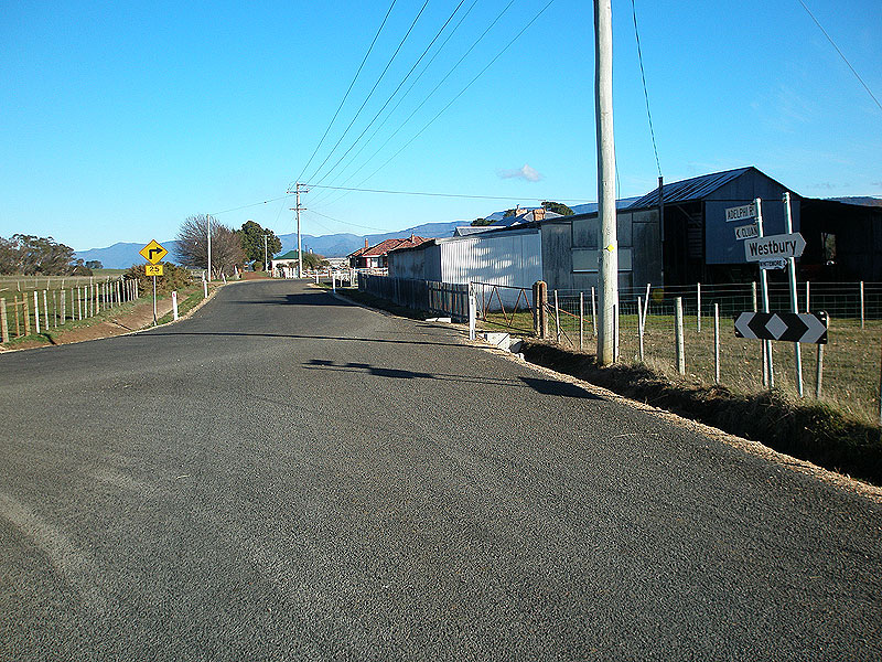  |
Two views of the intersection of Whitemore Rd (C507) & Adelphi Rd (C510). In the first photo there is no route marking signage whatsoever, as well as an incorrect focal point. In the second photo, taken some months later, Meander Valley Council has install two new fingerboards. However there is still no acknowledgement of route C510 which should be marked along Adelphi Rd. Top photo - Source: Peter Renshaw, June 2007 Bottom photo - Source: Peter Renshaw, October 2007. |
 |
Whitemore Rd (C507) looking east towards the intersection with Adelphi Rd (C510). Source: Peter Renshaw, June 2007. |
 |
Whitemore Rd (C507) looking east to the junction with Oaks Rd (C511), 5km north of Bracknell. Source: Peter Renshaw, June 2007. |
 |
A sunset photograph of the fingerboard assembly at the intersection of Oaks Rd (C511) & Whitemore Rd (C507), 5km north of Bracknell. Source: Peter Renshaw, May 2007. |
Last updated 26 January 2009. © Ozroads 2004-2009. |