Launceston to Low Head |

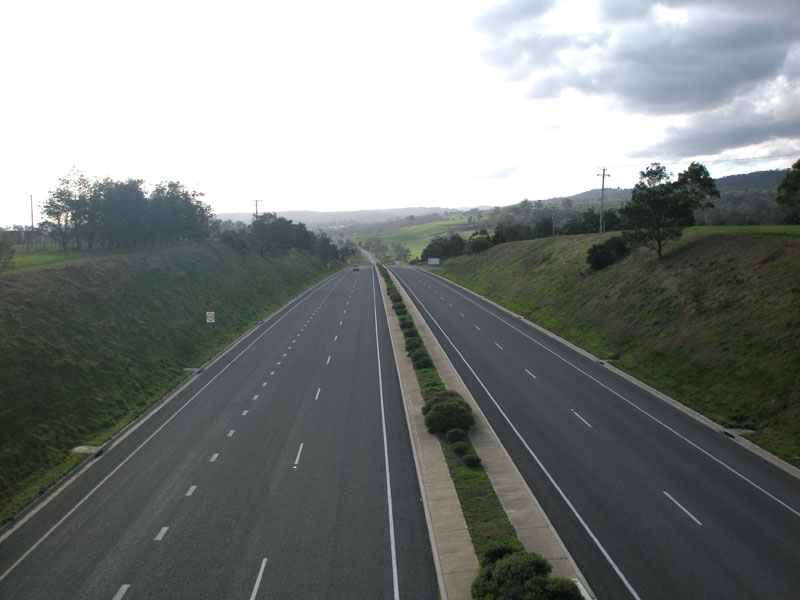
A8 (East Tamar Hwy) looking north to Barnards Creek as it leaves Launceston urban area. Source: Peter Renshaw, June 2007.
Introduced: 1980
Length: 55km
Northern Terminus: Low Head Lighthouse, Low Head
Southern Terminus: Brisbane Street (A7/A3), Launceston
Route taken: Bathurst St/Wellington St, Lower Charles St, East Tamar Highway, Main Road, Goulbourne Street, Low Head Road
Focal Points: Launceston, George Town, Low Head
Responsibility: State Government (Launceston-George Town), Local Government (George Town-Low Head)
Route A8 is a principal north-south route, beginning in Launceston and skirting the eastern bank of the Tamar River before terminating at Low Head Lighthouse, near where the Tamar River meets Bass Strait. The majority of route A8 is also the East Tamar Highway.
Route A8 begins in Launceston CBD with a couplet of one-way streets - Bathurst Street for northbound traffic and Wellington Street for southbound traffic - at the junction with York Street, continuing directly from route National Highway 1. Upon leaving Launceston CBD via Charles Street Bridge over the North Esk River, A8 joins the East Tamar Highway, which it follows for 47km north to George Town, then continuing northwards to Low Head via several local government roads.
Route A8 was introduced in 1980, during the staged construction of the East Tamar Outlet (current route of East Tamar Highway) project. Initially, the Outlet ended at Mowbray Link, so A8 followed Invermay Rd and George Town Rd through Mowbray and Alanvale. Upon opening of Stage 2 of the Outlet in 1981, which extended to Newnham Link, A8 bypassed Mowbray. When Stage 3 opened in 1992, extending the Outlet from Newnham to Landfall, A8 became the route that exists today, bypassing Alanvale.
The quality of road varies dramatically along the length of the route, from urban arterial standard through Launceston's inner north, to limited access dual and single carriageway along the Tamar River flats, and then a generally two-lane rural highway with overtaking lanes north to Bell Bay. Closer to Low Head, the road narrows significantly and line marking disappears before the route terminates at the entrance to Low Head Lighthouse.
The A8, between Launceston and Bell Bay, is part of the Auslink National Network due to its importance as the major access route to the Port of Bell Bay and will be the recpient of a $65 million upgrade between 2007-2010, involving extensive widening and pavement strengthening, a bypass of Dilston and the construction of a grade-separated trumpet interchange at the Batman Highway junction. More information on the work can be found here.
Key Dates:
1980 - Route introduced
1981 - East Tamar Outlet Stage 2 opened, bypassing Mowbray
1992 - East Tamar Outlet Stage 3 opened, bypassing Alanvale
Further Reading:
East Tamar Highway
|
Photos of route A8 |
|
 |
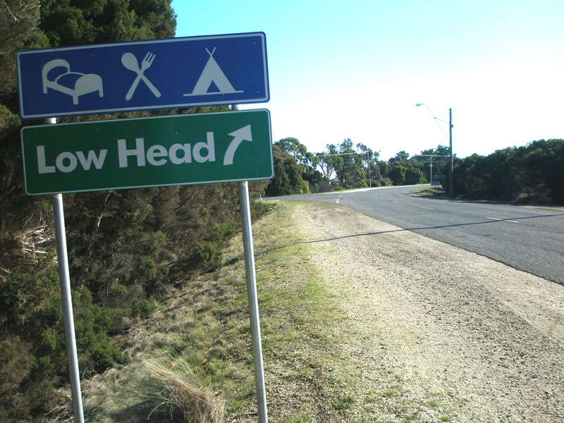
The northern end of A8 and Low Head Road, looking north at the entrance to Low Head Lighthouse.
Source: Peter Renshaw, June 2007. |
 |
Low Head Road (A8), looking south from Low Head Lighthouse. Source: Peter Renshaw, June 2007. |
 |
Low Head Rd (A8) looking south with historic Low Head Pilot Station buildings on the right. Note the narrow pavement and absence of line-marking. Source: Peter Renshaw, June 2007. |
 |
Historic mile-marker on Low Head Road (A8) outside Low Head Pilot Station, looking south. The 'L' stands for Launceston. Source: Peter Renshaw, June 2007. |
Historic mile-marker on Low Head Road (A8) outside Low Head Pilot Station, looking north. The 'LH' stands for Low Head. Source: Peter Renshaw, June 2007. |
|
 |
Low Head Rd (A8) looking south between Low Head and George Town with Cordell Point Lighthouse on the right. Note that the road is now wider and has line-markings. Source: Peter Renshaw, June 2007. |
 |
Poorly-designed Council signage at the intersection of Low Head Rd (A8) & Anne St, George Town. Note the absence of any A8 route markers. Source: Peter Renshaw, June 2007. |
 |
More dodgy Council signage, this time facing northbound traffic on Low Head Rd (A8) approaching Anne St, George Town. Source: Peter Renshaw, June 2007. |
 |
Low Head Rd (A8) looking south between Anne St and Davies St, George Town. Source: Peter Renshaw, June 2007. |
 |
Goulburn St (A8) looking south through George Town. Source: Peter Renshaw, June 2007. |
 |
Goulburn St (A8) looking south approaching the junction with Macquarie St & Main Road (A8) at George Town. A8 continues south as Main Road (formerly Low Head Main Road prior to its decommissioning). Source: Peter Renshaw, June 2007. |
 |
Dodgy Council signage in the centre of the Goulburn St/Macquarie St/Main Rd roundabout at George Town. Not very helpful if you are trying to navigate. Source: Peter Renshaw, June 2007. |
 |
Looking south along Main Rd (A8) through George Town. Source: Josh Geoghegan, Dec 2004. |
 |
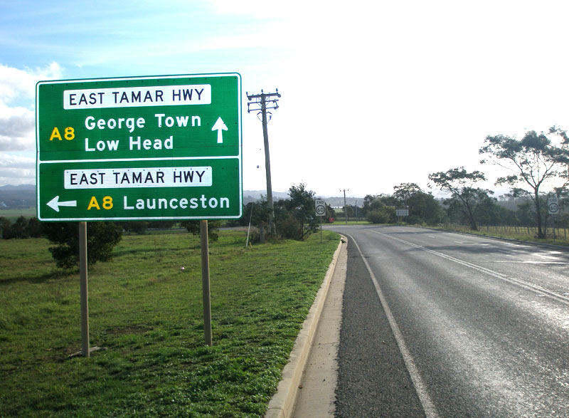
The northernmost mention of A8 - located at the junction of Main Rd (A8) & Victoria St, George Town. The East Tamar Highway begins a little further south at the town boundary.
Source: Peter Renshaw, June 2007. |
 |
East Tamar Highway (A8) southbound approaching the junction with Bell Bay Rd (C853), 4km south of George Town.
Source: Peter Renshaw, June 2007. |
 |
East Tamar Highway (A8) northbound approaching the junction with Bell Bay Rd (C853), 4km south of George Town.
Source: Peter Renshaw, June 2007. |
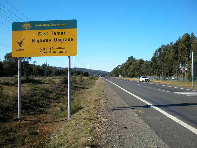 |
East Tamar Highway (A8) southbound between Bell Bay Rd (C853) and Bridport Main Rd (B82). The sign advertises the $60 million contribution of the Federal Government to a reconstruction program for the highway, involving extensive widening, strengthening and reconstruction between Landfall and Bell Bay.
Source: Peter Renshaw, June 2007. |
 |
East Tamar Highway (A8) distance sign, heading north from the junction with Bridport Main Rd (B82), 5km south of George Town.
Source: Peter Renshaw, June 2007. |
 |
East Tamar Highway (A8) southbound approaching the junction with Bridport Main Rd (B82). Note the use of a photograph on the sign to advertise the North East as a region of tourist significance.
Source: Peter Renshaw, June 2007. |
 |
Stock standard AD sign southbound on East Tamar Highway (A8) approaching Bridport Main Rd (B82).
Source: Peter Renshaw, June 2007. |
 |
AD sign westbound on Bridport Main Rd (B82) approaching the junction with East Tamar Highway (A8), 5km south of George Town.
Source: Peter Renshaw, June 2007. |
 |
Green fingerboard signs denoting a 'major rural' junction at the intersection of East Tamar Highway (A8) & Bridport Main Rd (B82).
Source: Peter Renshaw, June 2007. |
 |
East Tamar Highway (A8) northbound approaching the junction with Bridport Main Rd (B82), 5km south of George Town.
Source: Peter Renshaw, June 2007. |
 |
East Tamar Highway (A8) reassurance directional (RD) sign heading south from Bridport Main Rd (B82). Nothing much of any real importance on the highway between Bell Bay and Launceston.
Source: Peter Renshaw, June 2007. |
 |
Pictorial AD sign northbound on East Tamar Highway (A8) approaching Bridport Main Rd (B82).
Source: Peter Renshaw, June 2007. |
 |
East Tamar Highway (A8) looking south between Bridport Main Rd and Bell Bay Power Station.
Source: Peter Renshaw, June 2007. |
 |
East Tamar Highway (A8) looking south with Bell Bay Power Station on the right.
Source: Peter Renshaw, June 2007. |
 |
East Tamar Highway (A8) looking north at the entrance to Bell Bay Power Station, with Bell Bay port in the distance.
Source: Peter Renshaw, June 2007. |
 |
East Tamar Highway (A8) looking north across Williams Creek, south of Bell Bay Power Station. In this area, the highway and the Launceston-Bell Bay railway line share a path between the Tamar River and the Tippogoree Hills.
Source: Peter Renshaw, June 2007. |
 |
Fingerboard signs at the junction of East Tamar Highway (A8) and a private industrial road near Howells Reservoir.
Source: Peter Renshaw, June 2007. |
An atmospheric view of the East Tamar Highway (A8) as it parallels the Tamar River northwards to Bell Bay. Photo taken from the Batman Highway (B73) near its junction with Craigburn Rd (C727). Source: Peter Renshaw, May 2007. |
|
 |
East Tamar Highway (A8) looking south about 1km north of Batman Highway, showing recent reconditioning work.
Source: Peter Renshaw, June 2007. |
 |
Lovely original A8 distance sign, heading north on East Tamar Highway from the junctions with East Arm Rd (C810) and Batman Hwy (B73).
Source: Peter Renshaw, October 2007. |
 |
East Tamar Highway (A8) southbound approaching the junction with Batman Highway (B73). The junction with East Arm Rd (C810) is in the foreground.
Source: Peter Renshaw, October 2007. |
 |
Fingerboard signs at the junction of East Tamar Highway (A8) & East Arm Rd (C810), just north of Batman Hwy.
Source: Peter Renshaw, May 2007. |
 |
Fingerboard signs facing southbound and eastbound traffic at the junction of East Tamar Highway (A8) & Batman Highway (B73).
Source: Peter Renshaw, May 2007. |
 |
Fingerboard sign at the junction East Tamar Highway (A8) & Batman Highway (B73). Source: Peter Renshaw, May 2007. |
 |
Another original A8 sign, this time heading east on Batman Highway (B73) approaching East Tamar Highway (A8).
Source: Peter Renshaw, June 2007. |
  |
East Tamar Highway (A8) northbound approaching the junction with Batman Highway (B73). The coverplate covers a catamaran symbol which denoted the former vehicular catamaran service which operated between George Town and Port Welshpool in Victoria. Bottom: Replacement AD sign, northbound on East Tamar Highway (A8) approaching the junction with Batman Highway (B73). |
 |
East Tamar Highway (A8) looking south to Doctors Creek at Hillwood.
Source: Peter Renshaw, June 2007. |
 |
East Tamar Highway (A8) looking south approaching the junction with Jetty Rd (C727) at Hillwood.
Source: Peter Renshaw, June 2007. |
 |
Fingerboard signs at the junction with Jetty Rd (C727) at Hillwood.
Source: Peter Renshaw, June 2007. |
 |
AD sign northbound on East Tamar Highway (A8) approaching the junction with Jetty Rd (C727) at Hillwood.
Source: Peter Renshaw, May 2007. |
 |
East Tamar Highway (A8) looking south from Jetty Rd (C727) at Hillwood.
Source: Peter Renshaw, May 2007. |
 |
East Tamar Highway (A8) looking south towards the junction with Dalrymple Rd (C809) and Hillwood Rd.
Source: Peter Renshaw, May 2007. |
 |
East Tamar Highway (A8) southbound approaching the junction with Dalrymple Rd (C809) and Hillwood Rd. Source: Peter Renshaw, May 2007. |
 |
Fingerboard signs at the junction of East Tamar Highway (A8) & Dalrymple Rd (C809).
Source: Peter Renshaw, May 2007. |
 |
East Tamar Highway (A8) looking south near the old Mount Direction Signal Station, now a hotel.
Source: Peter Renshaw, May 2007. |
 |
East Tamar Highway (A8) southbound approaching the junction with Windermere Rd (C739). This is the northern end of C739 which forms a loop along the Tamar River foreshore.
Source: Peter Renshaw, May 2007. |
 |
Fingerboard signs at the junction of East Tamar Highway (A8) and Windermere Rd north (C739).
Source: Peter Renshaw, May 2007. |
 |
AD sign northbound on East Tamar Highway (A8) approaching the northern junction with Windermere Rd (C739). Source: Peter Renshaw, October 2007. |
 |
East Tamar Highway (A8) looking south near the northern junction with Windermere Rd (C739). Source: Peter Renshaw, October 2007. |
 |
Fingerboard signs at the junction of East Tamar Highway (A8) and Windermere Rd south (C739).
Source: Peter Renshaw, May 2007. |
 |
East Tamar Highway (A8) looking north approaching the junction with Windermere Rd south (C739).
Source: Peter Renshaw, June 2007. |
 |
East Tamar Highway (A8) looking north from the junction with Dilston Road north.
Source: Peter Renshaw, June 2007. |
 |
East Tamar Highway (A8) looking south at the junction with Dilston Rd south, Dilston.
Source: Peter Renshaw, May 2007. |
 |
East Tamar Highway (A8) looking south at Lees Orchard, Dilston. This hilly and winding section will be bypassed by the Dilston Bypass, to be constructed as part of the $65 million East Tamar Highway upgrade.
Source: Peter Renshaw, May 2007. |
 |
Looking south over the East Tamar Highway (A8) as it rises out of a valley below Lee's Orchard, Dilston.
Source: Peter Renshaw, June 2007. |
 |
East Tamar Highway (A8) looking south to the bridge over Barnards Creek and the Landfall Interchange, which marks the beginning of an 8km long deviation of the East Tamar Highway bypassing the northern suburbs of Launceston.
Source: Peter Renshaw, June 2007. |
|
East Tamar Highway (A8) looking north from Landfall to the bridge over Barnards Creek. Located at the bottom of a steep grade, the bridge is a notorious location for crashes, including a couple of spectacular vehicular suicides. It has even been featured by Austroads as an example of how not to design a road!
Source: Peter Renshaw, June 2007. |
 |
AD sign southbound on East Tamar Highway (A8) approaching the Landfall Interchange - junction with Lilydale Main Rd/George Town Rd (B81).
Source: Peter Renshaw, May 2007. |
 |
East Tamar Highway (A8) looking north from the Lilydale Main Rd (B81) overpass at Landfall. This short section of four-lane dual carriageway exists only on the immediate approaches to the interchange which is located at the crest of a large hill.
Source: Peter Renshaw, May 2007. |
 |
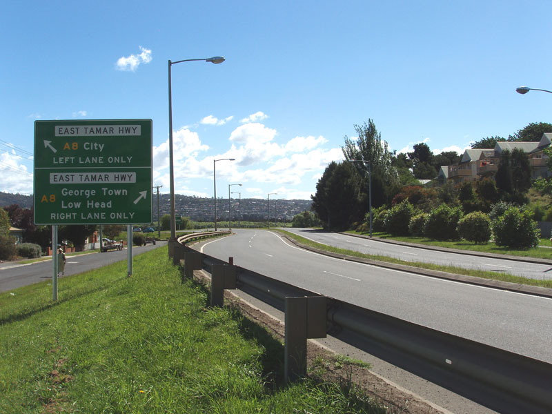
Fingerboard sign at the junction of East Tamar Highway (A8) & Lilydale Main Rd (B81), Landfall. Note the use of a name plate, used only within urban areas.
Source: Peter Renshaw, May 2007. |
 |
AD sign westbound on Lilydale Main Rd (B81) approaching the junction with East Tamar Highway (A8) at Landfall. Source: Peter Renshaw, May 2007. |
 |
East Tamar Highway (A8) looking south from the Lilydale Main Rd (B81) overpass at Landfall with the Tamar River as a magnificent backdrop. This deviation of the highway, which previously passed through Launceston's northern suburbs, was constructed along the flats/floodplain as the 'East Tamar Outlet'.
Source: Peter Renshaw, May 2007. |
 |
ID sign for Lilydale Main Rd/George Town Rd (B81) on East Tamar Highway (A8), northbound at Landfall.
Source: Peter Renshaw, May 2007. |
 |
East Tamar Highway (A8) looking north to the junction with Lilydale Main Rd/George Town Rd (B81) at Landfall.
Source: Peter Renshaw, May 2007. |
 |
Distance sign heading south on East Tamar Highway (A8) from Landfall Interchange.
Source: Peter Renshaw, May 2007. |
 |
East Tamar Highway (A8) looking south as it descends from Landfall onto the Tamar River flats. Note that the highway reverts to single carriageway across the flats as far as the Newnham Link.
Source: Peter Renshaw, May 2007. |
 |
East Tamar Highway (A8) looking south across the Tamar River flats between Landfall Interchange and Newnham Link.
Source: Peter Renshaw, May 2007. |
 |
Distance sign heading north on East Tamar Highway (A8) from the junction with Newnham Link.
Source: Peter Renshaw, May 2007. |
 |
East Tamar Highway (A8) southbound approaching the junction with Newnham Link, which provides access from the highway to the Launceston Campus of the University of Tasmania.
Source: Peter Renshaw, May 2007. |
 |
Newnham Link westbound at the junction with East Tamar Highway (A8).
Source: Peter Renshaw, May 2007. |
 |
Looking north from the pedestrian bridge over the junction of East Tamar Highway (A8) and Newnham Link. The Link actually formed part of Stage 2 of the 'East Tamar Outlet', carrying through traffic to George Town until the Outlet was extended north to Landfall.
Source: Peter Renshaw, May 2007. |
 |
Looking south over East Tamar Highway (A8) as it heads towards Launceston from Newnham Link. The added lane on the left comes from Newnham Link and the highway remains four lanes wide right into Launceston CBD.
Source: Peter Renshaw, May 2007. |
 |
East Tamar Highway (A8) northbound approaching Newnham Link. Source: Peter Renshaw, October 2007. |
 |
East Tamar Highway (A8) heading north from the junction with Mowbray Link. Source: Peter Renshaw, October 2007. |
 |
East Tamar Highway (A8) southbound approaching Mowbray Link at Mowbray. This link formed part of the first stage of the East Tamar Outlet, bypassing the former route via Invermay Rd.
Source: Peter Renshaw, May 2007. |
 |
Mowbray Link westbound approaching the junction with East Tamar Highway (A8), Mowbray.
Source: Peter Renshaw, November 2005. |
 |
East Tamar Highway (A8) looking south from the junction with Mowbray Link. Source: Peter Renshaw, October 2007. |
 |
East Tamar Highway (A8) northbound approaching the junction with Mowbray Link, Mowbray. Note that the newer signage uses 'Low Head' as a focal point, whilst signage dating from the introduction of route A8 in 1980 uses 'Bell Bay'. Source: Peter Renshaw, October 2007. |
 |
East Tamar Highway (A8) northbound approaching the junction with Mowbray Link, Mowbray. Source: Peter Renshaw, October 2007. |
 |
East Tamar Highway (A8) looking north from Mayne Street overpass, Invermay, showing the beginnings of the limited access road across the Tamar River flats. Source: Peter Renshaw, October 2007. |
 |
East Tamar Highway (A8) looking south from Mayne Street overpass, Invermay, showing the transition from limited access road to urban arterial. Source: Peter Renshaw, October 2007. |
 |
East Tamar Highway (A8) heading south in Invermay. Note the use of the local name - Goderich Street - despite the highway continuing south to the Charles Street Bridge.
Source: Peter Renshaw, May 2007. |
 |
AD sign eastbound on Forster St approaching East Tamar Highway (A8), Inveresk. Source: Peter Renshaw, October 2007. |
 |
Fingerboard sign at the junction of East Tamar Highway (A8) & Forster St, Inveresk. The East Tamar Highway is well and truly an urban arterial through Invermay, contrasting to the rural and limited access conditions experienced since George Town.
Source: Peter Renshaw, May 2007. |
 |
Fingerboard sign at the junction of East Tamar Highway (A8) & Forster St, Inveresk. Not sure I have ever seen a fingerboard sign with 'City 1' on it before - very unusual!
Source: Peter Renshaw, June 2007. |
 |
East Tamar Highway (A8) looking south from Forster St through Inveresk.
Source: Peter Renshaw, June 2007. |
 |
Lower Charles Street (A8) looking north to Charles Street Bridge from Esplanade, Launceston. The East Tamar Highway begins at the southern abutment of the bridge.
Source: Peter Renshaw, June 2007. |
 |
Lower Charles Street (A8) looking south from Esplanade towards Launceston CBD. The Wellington Street overpass carries the southbound carriageway across an extension of Cimitiere St.
Source: Peter Renshaw, June 2007. |
 |
Bathurst Street (A8) looking north at the Cimitiere Street off-ramp on the northern edge of Launceston CBD. Source: Peter Renshaw, February 2008. |
 |
Wellington Street (A8) looking south across the Cimitiere St extension towards Launceston CBD.
Source: Peter Renshaw, June 2007. |
 |
Cimitiere St looking west towards the Wellington St overpass, with Bathurst St - carrying northbound A8 traffic - in the background.
Source: Peter Renshaw, June 2007. |
 |
Wellington St (A8) looking south at the junction with Cimitiere St. Instead of a free-flowing merge, there is an unusual signalised intersection with unusual double-lanterned traffic signals.
Source: Peter Renshaw, June 2007. |
 |
Bathurst St (A8) northbound as it passes beneath Paterson St in Launceston. Note the overhead signage relating to the right-hand exit to Cimitiere St. |
 |
Fingerboard sign at the intersection of Bathurst St (A8/NH1) & Brisbane St (A3/A7) in Launceston CBD. The one-way street system creates confusion when trying to ascertain the exact terminii of these routes, which is basically four intersections bounding the block inside Brisbane, Bathurst, York and Wellington Streets.
Source: Peter Renshaw, June 2007. |
York St (A3/A7) westbound approaching the intersection with Bathurst St (A8), which is the southern terminus of A8, Launceston.
Source: Peter Renshaw, November 2005. |
|
Wellington St (NH1) northbound approaching the intersection with York St (A3/A7), Launceston, with signage denoting the beginning of A8 for northbound traffic.
Source: Peter Renshaw, November 2005. |
|
Tourist signage denoting A8, northbound on Wellington St (A8) at the intersection with York St (A3/A7), Launceston.
Source: Peter Renshaw, November 2005. |
|
Last updated 29 January 2009 © Ozroads 2004-2009. |