Sisters Beach |
The only mention of C233 - fingerboard signs at the junction of Port Road (C232) & Sisters Beach Road (C233). Source: Peter Renshaw, May 2012.
Introduced: 1980
Length: 7km
Eastern Terminus: Port Rd (C232) & Sisters Beach Rd (C232), 2km south of Boat Harbour Beach
Western Terminus: Sisters Beach Rd (C233) & Honeysuckle Ave, Sisters Beach
Route taken: Sisters Beach Rd
Focal Points: Sisters Beach
Responsibility: Local Government
C233 is a minor rural route on Tasmania's north western coast, linking Bass Highway (A2) with Rocky Cape National Park and the tiny village of Sisters Beach. The route is fully sealed, however the alignment is tortuous as it winds its way through the national park.
As a 'spur' route, heading to a dead end, there is only one junction with another numbered route - C232 at Port Road. The single right-pointing fingerboard at this junction is the only mention of C233, making the route a one-hit wonder.
|
Photos of route C233 |
|
  |
Older fingerboard signs, dating from the introduction of alpha-numeric route marking, at the intersection of Sisters Beach Road (C233) & Port Road (C232), 2km south of Boat Harbour Beach. |
 |
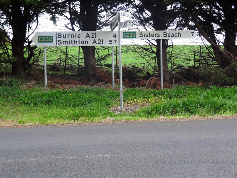
Replacement fingerboard signs at the junction of Sisters Beach Road (C233) & Port Road (C232), 2km south of Boat Harbour Beach. Note the screw up - Burnie has gone from 31km away to only 4km away! |
 |
Sisters Beach Road (C233) looking east towards the junction with Port Road (C232), which is located just before the bend. Source: Peter Renshaw, October 2007. |
 |
Sisters Beach Road (C233) looking west towards Pokes Road, approximately 500m west of Port Road (C232). |
 |
Sisters Beach Road (C233) looking east from the start of the winding section approximately 2km west of Port Road (C232). Source: Peter Renshaw, October 2007. |
 |
Looking west through the winding section between 1.5 and 2.5km west of Port Road (C232). The route passes through Rocky Cape National Park to reach Sisters Beach. Source: Peter Renshaw, October 2007. |
 |
Older style advisory speed limit sign, eastbound near Banksia Corner approximately 2.5km west of Port Road (C232). Source: Peter Renshaw, October 2007. |
Sisters Beach Road (C233) looking west towards Lake Llewellyn, approximately 5km west of Port Road (C232). |
|
 |
Looking west as Sisters Beach Road (C233) swings around the northern side of Lake Llewellyn. Source: Peter Renshaw, October 2007. |
Sisters Beach Road (C233) looking west through Rocky Cape National Park, west of Lake Llewellyn. Source: Peter Renshaw, October 2007. |
|
 |
Sisters Beach Road (C233) looking back into Rocky Cape National Park from the edge of Sisters Beach township. Source: Peter Renshaw, October 2007. |
  |
C233 terminates at the junction of Sisters Beach Road (C233) & Honeysuckle Avenue at Sisters Beach. The bottom photo shows the only signage which is provided at this junction - no mention of C233. Source: Peter Renshaw, October 2007. |
 |
A view of the foreshore area at Sisters Beach. Source: Peter Renshaw, October 2007. |
Last updated 5 August 2012. © Ozroads 2003-2012. |