West Scottsdale Loop |

AD sign eastbound on Tasman Highway (A3) approaching the eastern junction with Sledge Track (C830). Source: Peter Renshaw, April 2008.
Introduced: 1980
Length: 9km
Western Terminus: Tasman Highway (A3) & Sledge Track (C830), 10km southwest of Scottsdale
Eastern Terminus: Tasman Highway (A3) & Sledge Track (C830), 3km southwest of Scottsdale
Route taken: Sledge Track
Focal Points: West Scottsdale
Responsibility: Local Government
C830 is a 9km long, partly sealed loop from the Tasman Highway (A3) west of Scottsdale serving the locality of West Scottsdale. East of West Scottsdale, the route is generally comprised of a narrow sealed surface, whilst the western portion of the route has a well-maintained gravel surface.
|
Photos of route C830 (from east to west) |
|
 |
Top: AD sign westbound on Tasman Highway (A3) approaching the eastern junction with Sledge Track (C830), 3km southwest of Scottsdale. |
| |
AD sign eastbound on Tasman Highway (A3) approaching the eastern junction with Sledge Track (C830), 3km southwest of Scottsdale. |
  |
Top: C830 fingerboard sign at the eastern junction of Tasman Highway (A3) & Sledge Track (C830). Bottom: Deteriorating A3 fingerboards at the eastern junction of Tasman Highway (A3) & Sledge Track (C830). |
 |
Sledge Track (C830) looking southwest on the descent to the Brid River, 700m west of the junction with Tasman Highway (A3). Source: Peter Renshaw, April 2007. |
 |
Sledge Track (C830) looking west across the Brid River, 1.5km west of Tasman Highway (A3). Source: Peter Renshaw, April 2007. |
 |
Sledge Track (C830) looking east towards the crossing of the Brid River, 2km west of Tasman Highway (A3). |
 |
Sledge Track (C830) looking southwest at the junction with Old School Rd, West Scottsdale, 3km west of Tasman Highway (A3). The sign is a former fingerboard sign reconditioned to act as a locality name plate. |
 |
Sledge Track (C830) looking south, 400m south of old School Rd at West Scottsdale, with the Sideling Range in the background. Source: Peter Renshaw, April 2007. |
 |
Sledge Track (C830) looking south at McKays Rd, where the sealed surface ends, 1.7km south of West Scottsdale. Sledge Track remains unsealed for the journey to Tasman Highway (A3). |
 |
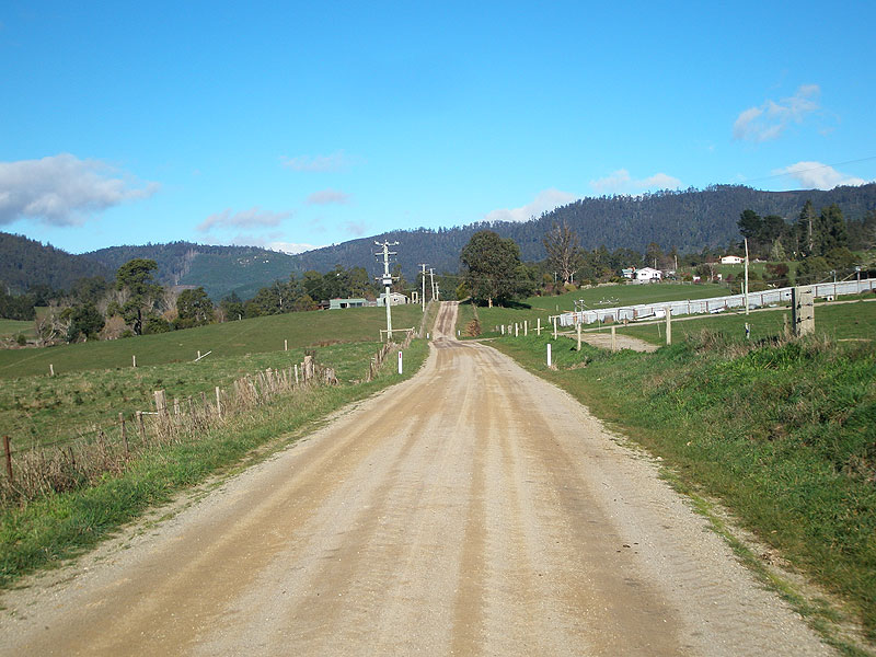
Sledge Track (C830) looking south approximately 1km south of Mckays Rd. Source: Peter Renshaw, April 2007. |
 |
The final stretch of Sledge Track (C830) photographed from the hills 2km north of Tasman Highway (A3). Source: Peter Renshaw, April 2007. |
 |
Sledge Track (C830) looking south across the Brid River flats, 1km north of Tasman Highway (A3). Source: Peter Renshaw, April 2007. |
 |
Sledge Track (C830) looking south to the junction with Tasman Highway (A3), 10km southwest of Scottsdale. Source: Peter Renshaw, April 2007. |
 |
Fingerboard and road-name signage at the western junction of Tasman Highway (A3) & Sledge Track (C830). Source: Peter Renshaw, April 2008. |
 |
Deteriorating A3 fingerboard sign assembly at the western junction of Tasman Highway (A3) & Sledge Track (C830) with the Tasman Highway in the background. Source: Peter Renshaw, April 2008. |
 |
AD sign westbound on Tasman Highway (A3) approaching the western junction with Sledge Track (C830), 10km southwest of Scottsdale. Source: Peter Renshaw, April 2008. |
 |
AD sign eastbound on Tasman Highway (A3) as it emerges from the Sideling Range on approach to the western junction with Sledge Track (C830). Source: Peter Renshaw, April 2008. |
Last updated 8 June 2009 © Ozroads 2004-2009. |