SOUTH AUSTRALIA
Route numbering for the 21st century!
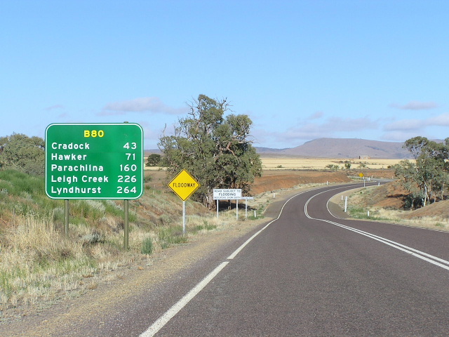
The B80 heading north from Carrieton, January 2004.
In 1998/99 Transport SA launched its new rural route numbering scheme consisting of alpha-numeric routes to aid navigation in a state that previously relied on the few National Highways and Routes. Under this scheme, a grea deal more intra-state and inter-regional routes would be numbered and signposted, creating obvious benefits for interstate travellers and tourists. A key part of the system is the marking of major tourist routes, such as the A13 to Victor Harbour, the B23 to Kangaroo Island and the B10 through the Torrens Valley. The system also provided for the first comprehensive route marking system in metropolitan Adelaide.
Prior to this, South Australia had a limited system of National Routes, progressively signposted from 1955 onwards. In addition, two Victorian State Routes had been extended from the border to the next major road in the south east of the state during the 1980's. Details on the old system can be found HERE.
In the changeover, generally the National Routes kept their old numbers but inherited a letter classification. The National Highway shields were retained and in some cases were given to new routes (the National Highway corridor through Adelaide was previosuly unnumbered). The exception to these generalisations was NR47 and NR83 which were mixed and matched to an extent. NR47 and part of NR83 is now the B83, while the southern section of the former NR83 is now B80 and B82.
South Australia brought only three classifications in; M, A & B. There are actually three"C" routes that have been extended from the Victorian Border to the Riddoch Highway (A/B66) but these don't really count as South Australian routes per se. Some maps show several "D" routes in the northern part of the state along unsealed tracks, however this is incorrect as Transport SA has a policy of not signposting route markers on unsealed roads. Since the mapping companies have recieved the route marking information from official sources, it is safe to assume that these are "secret" or "hidden" routes and will be signposted when these tracks are sealed in the future.
The alpha-numeric system can be split into the following categories. Those routes under the National Highways heading are those which carry the National Highway shield. Some of these routes continue without the National Highway shield and that section of the routes can be found under "Other alpha-numeric routes".
List of active alpha-numeric routes in South Australia
National Highway Routes
|
|
  |
|
|
Port Wakefield Road & Port Wakefield-Port Augusta Road |
|
Eyre Highway |
 |
|
 |
Grand Junction Road |
 |
Portrush Rd, Lower Portrush Rd, Ascot Ave, Taunton Rd & Hampstead Rd |
  |
Sturt Highway & Northern Expressway |
 |
Stuart Highway |
|
|
Glen Osmond Rd & Main North Rd (Adelaide) |
|
Port River Expressway |
|
Salisbury Hwy/South Rd/Main South Rd/Victor Harbour Rd |
|
Marion Rd/Holbrooks Rd |
|
Noarlunga to Port Adelaide |
|
Grand Junction Rd |
|
Kings Rd/MacIntyre Rd |
|
Barossa Valley Way |
|
Adelaide Ring Route |
|
Cavan Rd/Churchill Rd |
|
Main South Rd/Kangaroo Island |
|
Adelaide Hills route |
|
Barrier Highway Giles Corner to NSW Border via Burra & Terowie |
|
Mt Barker to Delamere |
|
Wellington to Strathalbyn |
|
Main North Road Gepps Cross to Gawler |
|
Murray Bridge to Berri |
|
Peterborough to Port Augusta (part of former National Route 56) |
|
Berri to Crystal brook (former National Route 64) |
|
Jamestown to Hallett |
|
Warnertown to Ucolta via Jamestown & Peterborough |
|
Clare to Hawker via Jamestown |
|
Thiele Highway Gawler to Morgan via Eudunda |
|
Horrocks Highway Gawler to Quorn via Tarlee, Clare, Gladstone, Wilmington |
|
Stirling North to Lyndhurst via Hawker |
|
Port Wakefield to Wallaroo |
|
Yorke Peninsula |
|
Warooka to Ardrossan via Edithburgh |
|
Port Pirie to Wallaroo |
|
Todd Highway |
|
Cowell to Elliston via Lock |
|
Old Sturt Highway, Berri |
|
Unofficial (and unsigned) 'D' Routes |
|
Lyndhurst to Marree, then Birdsville Track |
|
Oodnadatta Track |
|
Strzelecki Track |
|
Borefield Road |
|
Last updated 8 December 2012 © Ozroads 2003-2012. |