Southern Ports Highway |
AD sign approaching the B101 Southern Ports Highway from Main Road at Robe. Photo taken: January 2005.
Length: 121km
Northern Terminus: Princes Highway (B1) & East Terrace (B101), Kingston S.E.
Southern Terminus: Princes Highway (B1) & Ridge Terrace (B101), Millicent
Route taken: From Millicent via Ridge Terrace, Main Street, Rendelsham Road, Southern Ports Highway and East Terrace, to Kingston S.E.
Focal Points: Kingston S.E., Robe, Beachport, Millicent
Route B101, Southern Ports Highway, is an alternative coastal route to the Princes Highway between Millicent and Kingston S.E. In fact, until 1933 the current route of the Southern Ports Highway was part of the Princes Highway. The highway was fully sealed in 1978 and thus received the Alternative National Route 1 shield - which was replaced in 1999 by the current B101 designation. As of January 2005 signage was about 50/50 between the number of Alt-1 signs and the number of B101 signs.
The route generally comprises good quality 2-lane rural highway. Motorists are required to turn off to stay on the route at a number of locations as historically the roads radiating from Robe and Beachport were the more important through routes. Southern Ports Highway comprises a collection of roads linking these radial routes.
For photos of signage remnants from Alt-NR1 click HERE.
Photos of route B101 (Southern Ports Highway) |
|
 |
Typical South Australian alternative route AD sign southbound on Princes Highway approaching the junction with Southern Ports Highway at Kingston S.E. Photo taken: January 2005. |
 |
Standard AD sign southbound on Princes Highway approaching the junction with Southern Ports Highway at Kingston S.E. Note how Princes Highway is on the top panel - presumably done to highlight the dominant route. Photo taken: January 2005. |
  |
Two photos of the AD sign westbound on Princes Highway approaching the junction with Southern Ports Highway. Note how the sign has been relocated since the top photo was taken in 2005. Top photo: January 2005. Bottom photo: Peter Renshaw, October 2011. |
 |
ID sign assembly marking the start of route B101, at the junction of Princes Highway & Southern Ports Highway, Kingston S.E. Photo taken: January 2005. |
 |
AD sign southbound on Southern Ports Highway (East Terrace) approaching Agnes Street, Kingston S.E. Photo taken: January 2005. |
 |
AD sign northbound on Southern Ports Highway approaching the junction with Princes Highway, which still shows the old National Route 1 shields. Note the AD sign from the previous picture to the right. Photo taken: January 2005. |
 |
Southern Ports Highway (East Terrace) looking south through Kingston S.E. The town centre is located west of the highway. Photo taken: January 2005. |
 |
AD sign southbound on Southern Ports Highway approaching the junction with Cape Jaffa Road, 5km south of Kingston S.E. Photo taken: January 2005. |
 |
AD sign northbound on Southern Ports Highway approaching the junction with Cape Jaffa Road, 5km south of Kingston S.E. Photo taken: January 2005. |
 |
AD sign assembly southbound on Southern Ports Highway approaching the junction with Limestone Coast Road at Wangolina, 17km south of Kingston S.E. Photo taken: January 2005. |
 |
ID sign assembly facing southbound traffic at the junction of Southern Ports Highway & Limestone Coast Road, Wangolina. Photo taken: January 2005. |
 |
Typical South Australian rural services sign, southbound on Southern Ports Highway, 5km north of Robe. Photo taken: January 2005. |
 |
Typical South Australian rural tourist attractions sign on the northern approach to Robe. Photo taken: January 2005. |
 |
AD sign southbound on Southern Ports Highway approaching the junction with Main Road, Robe. The town centre is located to the west of the highway. Photo taken: January 2005. |
 |
AD sign eastbound on Main Road approaching the junction with Southern Ports Highway at Robe. Photo taken: January 2005. |
 |
ID sign at the junction of Southern Ports Highway & Main Road, Robe. Photo taken: January 2005. |
 |
AD sign westbound on Southern Ports Highway approaching the junction with Main Road, Robe. Photo taken: January 2005. |
 |
RD sign westbound on Southern Ports Highway near the junction with Clay Wells Road, 18km southeast of Robe. Photo taken: January 2005. |
 |
AD sign westbound on Clay Wells Road approaching Southern Ports Highway, 18km southeast of Robe. Photo taken: January 2005. |
 |
ID sign at the junction of Southern Ports Highway & Beachport-Penola Road, 6km northeast of Beachport. Photo taken: January 2005. |
 |
AD sign northbound on Southern Ports Highway approaching the junction with Beachport-Penola Road. Note that B101 traffic must turn left to remain on the route. Photo taken: January 2005. |
 |
RD sign northbound on Southern Ports Highway as you leave Beachport. Interestingly, the sign assembly on the other side of this sign still shows the obsolete Alternative National Route 1 shield. Photo taken: January 2005. |
 |
Transport SA (now Department of Planning, Transport & Infrastructure) workers installing brand new ID signs at the junction of Southern Ports Highway & Millicent Road, Beachport. Photo taken: January 2005. |
 |
ID sign at the junction of Southern Ports Highway & Millicent Road (the access road to Beachport). This sign has since been replaced with one that excludes the road name and omits reference to Penola! Photo taken: January 2005. |
 |
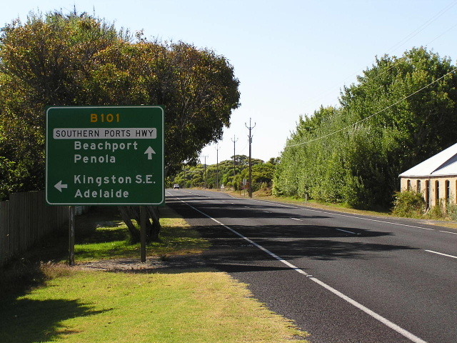
AD sign westbound on Southern Ports Highway approaching the junction with Millicent Road. Note that B101 traffic must turn right to remain on the route. Photo taken: January 2005. |
 |
RD sign northbound on Southern Ports Highway near the junction with Southend Access Road, 15km southeast of Beachport. Photo taken: January 2005. |
 |
AD sign southbound on Southern Ports Highway approaching the junction with Southend Access Road, 15km southeast of Beachport. Photo taken: January 2005. |
 |
RD sign southbound on Southern Ports Highway after the junction with Southend Access Road, 15km southeast of Beachport. Photo taken: January 2005. |
 |
ID sign at the junction of Southern Ports Highway (Rendelsham Road) & Williams Road on the western outskirts of Millicent. This is, as at October 2011, one of only two signs showing B101 in Millicent. Source: Peter Renshaw, October 2011. |
 |
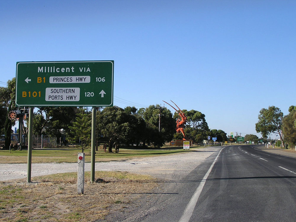
ID sign assembly at the junction of Princes Highway (Ridge Terrace/George Street) & Southern Ports Highway (Ridge Terrace), Millicent. Despite the heavy vehicle bypass providing a more direct route towards Mt Gambier, B101 links with Princes Highway at this junction. Photo taken: January 2005. |
Last updated 7 February 2012 © Ozroads 2003-2012. |