Adelaide - Birdwood - Nuriootpa |
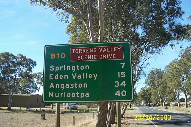
RD sign looking north on Torrens Valley Road at Mt Pleasant. Photo taken: April 2003.
Length: 105km
Northern Terminus: Barossa Valley Way (B19) & Railway Terrace (B10), Nuriootpa
Southern Terminus: Robe Terrace (A21) & Walkerville Terrace (A10) & Northcote Terrace, North Adelaide
Route taken: Northcote Terrace, North East Road, Torrens Valley Road, Eden Valley Road, North Street, Murray Street, Angaston Road, Railway Terrace
Focal Points: Adelaide, Modbury, Tea Tree Gully, Birdwood, Mt Pleasant, Angaston, Nuriootpa
Route A10/B10 begins in North Adelaide as a major urban arterial to Modbury and Tea Tree Gully. From there it heads into the Adealide Hills as the Torrens Valley Scenic Drive and ends up in Nuriootpa via Mount Pleasant and Angaston. The A10 designation changes to B10 at Hancock Road in Tea Tree Gully which is where the road changes from urban arterial to winding mountain road.
There are three duplexes along the route, with the B31, B34 and B35 all rather poorly signed.
Prior to the introduction of alpha-numeric route marking in South Australia, the route was unnumbered, except for portions which were part of Tourist Drive 58 around the lower Adelaide hills area.
Photos of route B10 (Nuriootpa to Adelaide) |
|
 |
Older black AD sign assembly southbound on Barossa Valley Way in Nuriootpa approaching the junction with Railway Terrace. Photo taken: January 2005. |
 |
Older black ID signs at the junction of Barossa Valley Way & Railway Terrace, Nuriootpa. Note the B10 topknot has been provided but a B19 topknot has not been provided for the 'Town Centre' ID sign. Photo taken: January 2005. |
  |
Old and new AD signs westbound on Railway Terrace (B10) approaching the junction with Barossa Valley Way (B19) at Nuriootpa. Top photo: April 2003. Bottom photo: Peter Renshaw, October 2011. |
 |
ID sign dating from the 1980s at the junction of Murray & Sturt Streets, Angaston. This sign has since been removed. Photo taken: April 2003. |
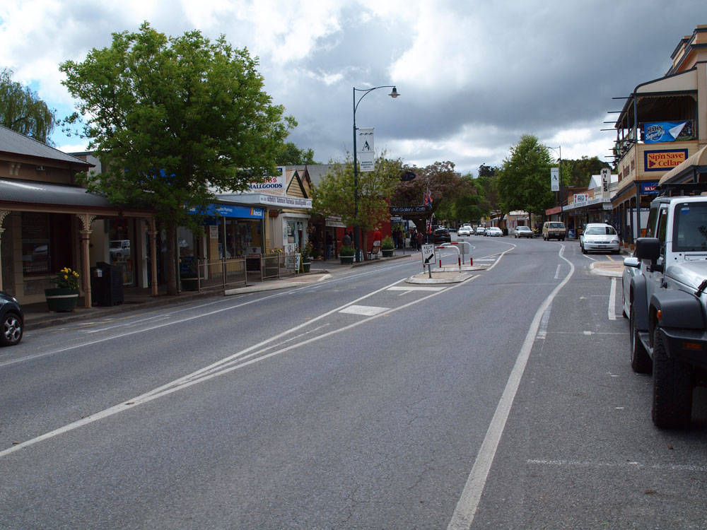 |
Murray Street looking east through Angaston town centre. Source: Peter Renshaw, October 2011. |
 |
ID sign facing northbound traffic at the junction of North & Murray Streets, Angaston. Source: Peter Renshaw, October 2011. |
 |
Older AD sign northbound on North Street approaching the junction with Murray Street, Angaston. Note the B10 topknot and the ampersand. Source: Peter Renshaw, October 2011. |
 |
Old black AD sign assembly southbound on North Street approaching the junction with Eden Valley Road (straight ahead) and Stott Highway (left) on the southern outskirts of Angaston. |
 |
ID signs at the junction of North Street (B10), Eden Valley Road (B10) & Stott Highway, Angaston. Photo taken: April 2003. |
 |
Attractive tree-lined section of Eden Valley Road, looking south at Flaxman Valley, near Craneford Road. Source: Peter Renshaw, October 2011. |
 |
Older AD sign assembly southbound on Eden Valley Road approaching the junction with Keyneton Road, Eden Valley. Note the unusual, non-standard green colour used for the background. Photo taken: April 2003. |
 |
Older AD sign assembly northbound on Eden Valley Road approaching the junction with Keyneton Road, Eden Valley. Again note the unusual green background, which has aged more on this sign. Photo taken: April 2003. |
 |
RD sign on Eden Valley Road heading south from Springton. Note that the B10 route marker is on a coverplate over "Torrens Valley Scenic Drive". Photo taken: April 2003. |
 |
RD sign northbound on Torrens Valley Road as you leave Mt Pleasant. Photo taken: April 2003. |
 |
AD sign southbound on Eden Valley Road approaching the junction with Walker Flat Road, Mt Pleasant. Photo taken: April 2003. |
 |
ID sign at the junction of Eden Valley Road (right), Torrens Valley Road (left) & Walker Flat Road, Mt Pleasant. Photo taken: April 2003. |
 |
AD sign assembly southbound on Torrens Valley Road approaching Tungkillo Road at Mt Pleasant. B35 has a short duplex with B10 through Mt Pleasant and should be shown straight ahead on this sign as well as left. Photo taken: April 2003. |
 |
AD sign eastbound on Cricks Mill Road approaching the junction with Torrens Valley Road, Mt Pleasant. B35 should be shown left, as it duplexes with B35 for a short section through Mt Pleasant between Cricks Mill and Tungkillo Roads. Photo taken: April 2003. |
 |
AD sign northbound on Torrens Valley Road approaching the junction with Cricks Mill Road, Mt Pleasant. B35 should be shown straight ahead and left. Photo taken: April 2003. |
 |
AD sign southbound on South Para Road (B31) approaching the junction with North East Road (B10/B31) at Chain of Ponds. Note the missing B31 route marker for the right turn, even though it appears that space was left for it above the B10 route marker. Photo taken: January 2005. |
 |
Very old ID signs at the B10/B31 intersection. Note that A10 is incorrectly shown instead of B10 and B31 is incorrectly not shown for the left turn. Photo taken: January 2005. |
 |
AD sign westbound on North East Road approaching the junction with Tippett Road, Chain of Ponds. The short B10/B31 duplex ends here with route B31 turning left onto Tippett Road - not that you would know it since it is incorrectly omitted from the sign. Photo taken: January 2005. |
 |
Unique to SA alternative route AD sign at the junction of North East Road (B10/B31) & Tippett Road (B31), Chain of Ponds. This sign would be better located before the intersection so motorists can make their decision before reaching the intersection. Photo taken: January 2005. |
 |
North East Road looking west alongside Millbrook Reservoir, approximately 2km west of Tippett Road. Photo taken: January 2005. |
 |
North East Road looking west through the small village of Houghton. Photo taken: January 2005. |
 |
AD sign westbound on North East Road (B10) approaching the junction with Lower North East Road (A11) at Houghton. Note the unusual situation where an A-route terminates on a B-route - A11 does not change to B11 when leaving the Adelaide urban area, presumably because of the short distance before its terminus. Photo taken: January 2005. |
 |
RD sign eastbound on North East Road (B10) near Haines Road, Tea Tree Gully. Photo taken: January 2005. |
 |
North East Road (A10) looking southwest at the junction with Montague Road, Modbury. This trailblazer appears to have since been removed. Photo taken: January 2005. |
 |
AD sign westbound on North East Road (A10) approaching the junction with Wrights Road (B18), Modbury. Photo taken: January 2005. |
 |
AD sign southbound on North East Road (A10) approaching Grand Junction Road (A16) at Holden Hill. Photo taken: January 2005. |
 |
North East Road looking south east near Sudholz Road, Gilles Plains. Photo taken: January 2005. |
 |
AD sign northbound on Northcote Terrace (A10) approaching the junction with Nottage Terrace, Stephen Terrace and North East Road (A10), Medindie. Photo taken: January 2005. |
 |
Northcote Terrace (A10) looking north through Medindie. Photo taken: January 2005. |
 |
Very old signage on Park Terrace (A21) northbound approaching the junction with Northcote Terrace (A10) and Walkerville Terrace in North Adelaide. Note the A10 shield is absent - it should be shown on the sign reading 'To N.E. Road'. Photo taken: January 2005. |
Last updated 20 March 2012 © Ozroads 2003-2012. |