Murray Bridge to Mount Crawford |
RD sign northbound on Reedy Creek Road north of the junction with B36 Mannum Road. Source: Peter Renshaw, October 2011.
Length: 63km
Northern Terminus: Warren Road (B34) & Cricks Mill Road (B35), 10km southeast of Williamstown
Southern Terminus: South Eastern Freeway (M1) & Jervois Road (B35), Swanport
Route taken: Jervois Road, Mannum Road, Reedy Creek Road, Randell Road, Tungkillo Road, Torrens Valley Road, Cricks Mill Road
Focal Points: Wellington, Murray Bridge, (Mannum), Palmer, Tungkillo, Mt Pleasant, (Williamston)
Route B35 is a northwest to southeast route skirting the eastern edge of the hills behind Adelaide. Linking Murray Bridge with Mount Pleasant and Williamstown, it provides a useful alternative route into the Barossa Valley or conversely to the South East without passing through the metropolitan area. Most of the route passes through lovely rolling countryside before entering the forests northwest of Mt Pleasant.
Beginning at the South Eastern Freeway (M1) at Swanport, just south of Murray Bridge, B35 heads north through Murray Bridge towards Mannum. North of the city centre, B35 makes a left turn onto Reedy Creek Road, the direct route to Palmer. Upon reaching Palmer, B35 traffic must turn again onto Randell Road before another turn, this time onto Tungkillo Road, just beyond Tungkillo. At Mt Pleasant, a short duplex with route B10 is used, before following Cricks Mill Road to its terminus at Warren Road (B34).
Signage:
B35, along with the other South Australia alpha-numeric routes, was officially introduced in 1998/99. Unfortunately, up until recently the route marker was missing from the majority of signs, particularly those southeast of Tungkillo. The duplex with route B10 through the village of Mt Pleasant is also poorly signed, as the photos below will show.
In 2009, as a result of an injection of funding for new signs under the rural addressing scheme, some new signs began appearing, e.g. at the junction with B36 just north of Murray Bridge. As at early 2014, it appears that the route has finally been fully signed, at least north of Murray Bridge.
Photos of route B35 (Swanport to Mount Crawford) |
|
 |
AD sign westbound on South Eastern Freeway (M1) approaching the Jervois Road (B35) interchange at Swanport. Note the missing B35 route marker - this sign pre-dates alpha-numeric route marking in South Australia. Photo taken: January 2005. |
 |
AD sign assembly northbound on Jervois Road (B35) at the junction with South Eastern Freeway (M1), Swanport. Again note the missing B35 route marker, despite the NHRA1 route marker being added to the lower sign. Photo taken: January 2005. |
 |
AD sign eastbound on Adelaide Road (B55, former Princes Highway) approaching the junction with Mannum and Jervois Roads, Murray Bridge. Swanport Road has since been renamed, however this photo was taken prior to the renaming. Note the B55 route marker has been added to the sign but not the B35 route marker which should be shown both left and right. Photo taken: January 2005. |
 |
AD sign westbound on Bridge Street (B55, former Princes Highway) approaching the junction with Mannum and Jervois Roads, Murray Bridge. Swanport Road has since been renamed, however this photo was taken prior to the renaming. Note the B55 route marker has been added to the sign but not the B35 route marker which should be shown both left and right. Photo taken: January 2005. |
 |
ID sign assembly facing southbound traffic at the junction of Mannum Road (B35/B36) and Reedy Creek Road, 3km north of Murray Bridge. Northbound B35 traffic must turn left at this junction into Reedy Creek Road to remain on the route. Source: Peter Renshaw, October 2011. |
 |
RD sign northbound on Reedy Creek Road after the junction with Mannum Road, 3km north of Murray Bridge. Source: Peter Renshaw, October 2011. |
 |
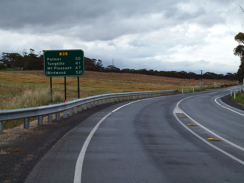
Reedy Creek Road looking north as you descend towards the bridge over Reedy Creek, 5km south of Palmer. Source: Peter Renshaw, October 2011. |
  |
Top photo: Ageing black AD sign assembly eastbound on Randell Road (B35) approaching the junction with Reedy Creek Road (B35) at Palmer. B35 traffic turns right at this junction to remain on the route whilst Randell Road continues straight ahead as B36. As you can see, neither sign had been updated to include the new route markers, 13 years after alpha-numeric route marking was introduced. Bottom photo: New AD sign showing both B35 and B36, installed during 2012. |
 |
AD sign southbound on Tungkillo Road (B35) approaching the junction with Randell Road, Tungkillo. Source: Rollo Ross, February 2014. |
  |
ID signs at the junction of Torrens Valley Road (B10/B35) & Tungkillo Road (B35), Mt Pleasant. The top photo shows the topknot initially installed; the second photo shows new signage including the route marker. Top photo: April 2003. Bottom photo: Rollo Ross, February 2014. |
 |
AD sign assembly southbound on Torrens Valley Road approaching Tungkillo Road at Mt Pleasant. B35 has a short duplex with B10 through Mt Pleasant and should be shown straight ahead on this sign as well as left. Photo taken: April 2003. |
 |
AD sign northbound on Torrens Valley Road approaching the junction with Cricks Mill Road at Mt Pleasant. This is the other end of the the short B10/B35 duplex and B35 should be shown straight as well as left on this sign. Photo taken: April 2003. |
 |
AD sign southeastbound on Cricks Mill Road (B35) approaching the junction with Torrens Valley Road (B10/B35), Mt Pleasant. B35 should, of course, be shown for the left turn, along with Murray Bridge and/or Mannum. Photo taken: April 2003. |
  |
ID sign assemblies at the junction of Warren Road (B34) & Cricks Mill Road (B35), 10km southeast of Williamstown. These signs, at the northwestern terminus of the route, pre-date alpha-numeric route marking but are correctly topknotted - if only the remainder of the signage on this route was as good. Photos taken: April 2003. |
 |
AD sign southbound on Warren Road (B34) approaching the junction with Cricks Mill Road (B35). Note the incorrectly capitalised 'W' and also how B34 is included in the sign but B35 is on a topknot - an unusual sign all round! Photo taken: April 2003 |
Last updated 16 February 2014 © Ozroads 2003-2014. |