Williamstown - Hahndorf - Myponga |
B34 ID sign on the Princes Highway at Verdun. Photo taken: January 2005.
Length: 112km
Northern Terminus: Warren Road (B34), Queen St & Victoria Tce (B31), Williamstown
Southern Terminus: Main South Road (A13) & Pages Flat Rd (B34), Myponga
Route taken: From Williamstown via Warren Road, Torrens Valley Road, Onkaparing Valley Road, Mount Barker Road, Echunga Road, Strathalbyn Road, Battunga Road, Dashwood Gully Road, Brookman Road, Victor Harbor Road and Pages Flat Road to Myponga
Focal Points: Williamstown, Birdwood, Woodside, Hahndorf, Meadows, Willunga, Myponga
B34 is a cross-regional route between the Barossa Valley and the Fleurieu Peninsula via the Adelaide Hills. It is fairly well signed north of the Princes Highway however, as of 2005, route marker signage is almost non-existant south of Hahndorf. Before 1998 the route was previously unnumbered except for a small section whcih was a poorly-signed tourist drive.
Photos of route B34 (Williamstown to Myponga) |
|
 |
ID sign assembly marking the northern terminus of route B34 at the junction of Victoria Terrace (B31), Queen Street (B31) & Warren Road (B34), Williamston. Photo taken: January 2005. |
 |
Typical old SA sign assembly with a B34 topknot at the junction of Mount Crawford Road (B34) & Springton Road, 2km east of Williamstown. Photo taken: April 2003. |
 |
AD sign southbound on Warren Road (B34) approaching the junction with Cricks Mill Road (B35), 10km southeast of Williamston. Photo taken: April 2003. |
 |
ID sign assembly at the junction of Warren Road (B34) & Cricks Mill Road (B35), 10km southeast of Williamston. Photo taken: April 2003. |
 |
Nice old black ID sign at the junction of Torrens Valley Road (B10/B34) & Onkaparinga Valley Road (B34), Birdwood. Note the dodgy addition of the B34 route marker on the sign - definitely better than no route marker! Source: Peter Renshaw, February 2011. |
 |
AD sign northbound on Mount Barker Road approaching the junction with Onkaparinga Valley Road (B34) at Verdun. Note the tourist route name 'Onkaparinga Scenic Drive'. I'm not sure if these routes are still actively signposted. Photo taken: January 2005. |
 |
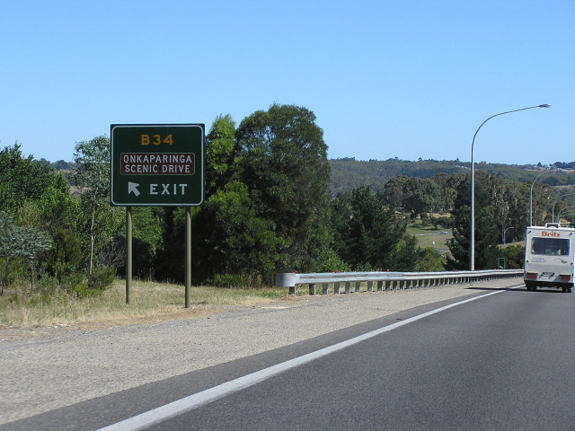
ID sign at the junction of Mount Barker Road & Onkaparinga Valley Road, Verdun. Photo taken: January 2005. |
 |
AD sign southbound on Mount Barker Road (B34) approaching the junction with South Eastern Freeway (NHRM1) at Verdun. Note the brighter shade of yellow for the B34 route marker to ensure it stands out. Also note how the signs refer to Princes Highway, rather than South Eastern Freeway, which is the official road name. Photo taken: January 2005. |
    |
Eastbound signage on South Eastern Freeway (NHRM1) approaching the Verdun interchange. Note how only one sign actually shows the B34 route marker. Photos taken: January 2005. |
 |
Old black RD sign on Mount Barker Road (B34), heading east from the junction with South Eastern Freeway at Verdun. This sign needs to be updated with one that includes the B34 route marker and some additional focal points (i.e. Echunga and Murray Bridge). Source: Peter Renshaw, February 2011. |
 |
ID sign assembly, complete with old SA style fingerboards and an old tourist sign at the junction of Strathalbyn Road (B33/B34) & Echunga Road (B34), Echunga. B34 turns left here onto a short duplex with B33 before turning right onto Battunga Road. Note the incorrect omission of B33 for the left-pointing sign. Source: Peter Renshaw, February 2011. |
 |
AD sign northbound on Victor Harbor Road (A13/B34) approaching the junction with Brookman Road (B34), south of Willunga. Note the incorrect omission of B34 for the right turn. Photo taken: January 2005. |
 |
RD sign southbound on Victor Harbor Road (A13/B34) on the short A13/B34 duplex south of Willunga. Note the sign incorrectly omits any reference to B34 or its focal points. Photo taken: January 2005. |
 |
RD sign northbound on Victor Harbor Road (A13/B34) on the short A13/B34 duplex south of Willunga. Note the sign incorrectly omits any reference to B34 or its focal points. Photo taken: January 2005. |
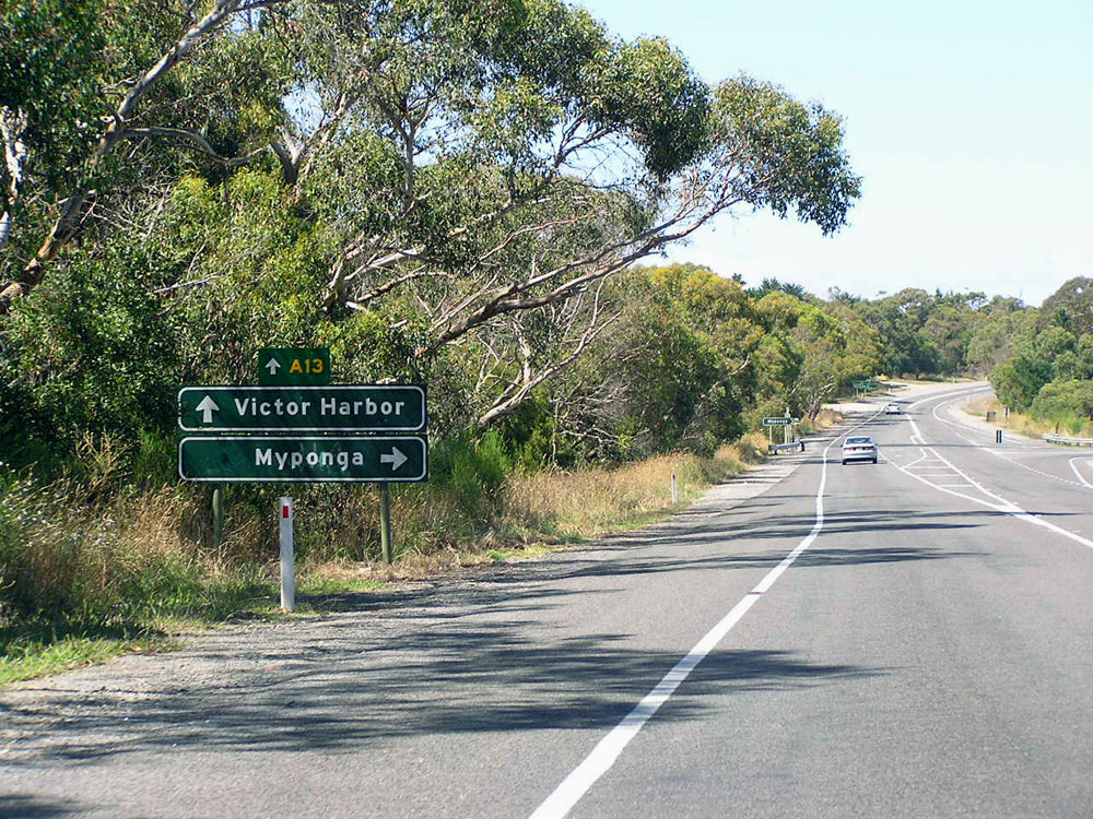 |
Typical older AD sign assembly southbound on Victor Harbor Road (A13/B34) approaching the junction with Pages Flat Road (B34), south of Willunga. Note that a topknot has been added for A13 but not for B34. Photo taken: January 2005. |
 |
Typical older ID sign assembly at the junction of Victor Harbor Road (A13/B34) & Pages Flat Road (B34), south of Willunga. Note that a topknot has been added for A13 but not for B34. Photo taken: January 2005. |
 |
Typical older AD sign assembly eastbound on Victor Harbor Road (A13/B34) approaching the junction with Pages Flat Road (B34), south of Willunga. Note that a topknot has been added for A13 but not for B34. Photo taken: January 2005. |
Last updated 20 March 2012 © Ozroads 2003-2012. |