Looking south from Port Bonython turnoff. Jan 2005.
Length: 765km
Eastern Terminus: Eyre Highway & Lincoln Hwy, 26km west of Port Augusta
Western Terminus: Eyre Highway & Flinders Hwy, 6km east of Ceduna
Route taken: Lincoln Highway, Flinders Highway
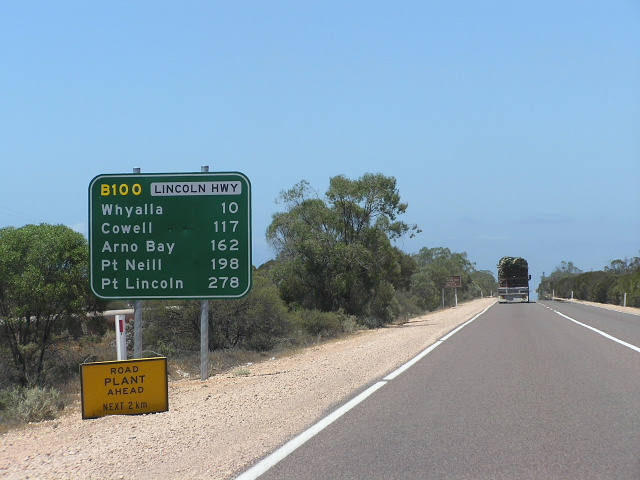
Focal Points: Port Augusta, Whyalla, Cowell, Arno Bay, Tumby Bay, Port Lincoln, Elliston, Streaky Bay, Ceduna
The B100 replaced the former Alternative National Route 1 on the Eyre Peninsula in 1999, utilising the Lincoln and Flinders Highways. The Lincoln Highway begins at the Eyre Highway, 26km west of Port Augusta and ends at the Flinders Hwy (Light St) in Port Lincoln. The Flinders Hwy begins at the Lincoln Hwy (Hallet St) in Port Lincoln, and runs northwest to the Eyre Highway 6km east of Ceduna.
Both highways were named by the Highways Department in 1938, with the Lincoln Highway the first to be 'opened'. After an extensive reconstruction and bitumen sealing program, the Lincoln Highway was officially opened in October 1960. The Flinders Highway was opened much later, in February 1978, with the completion of sealing between Talia and Streaky Bay.
For photos of signage remnants of Alt-NR1 click HERE.
Photos of the B100 - Lincoln and Flinders Highways |
|
 |
The first mention of B100, westbound on the Eyre Highway approaching the Lincoln Highway junction. Jan 2005. |
 |
And again. Jan 2005. |
 |
Heading south at the Port Bonython turnoff. Jan 2005. |
 |
Heading north from the Port Bonython Turnoff. Jan 2005. |
 |
Heading north near teh BHP Steelworks in Whyalla. Jan 2005. |
 |
Heading east on McBryde Tce approaching the Lincoln Hwy in Whyalla. Jan 2005. |
 |
Sign assembly at the Lincoln Hwy/Broadbent Tce junction in Whyalla. Jan 2005. |