NATIONAL HIGHWAY 25
Barton Highway
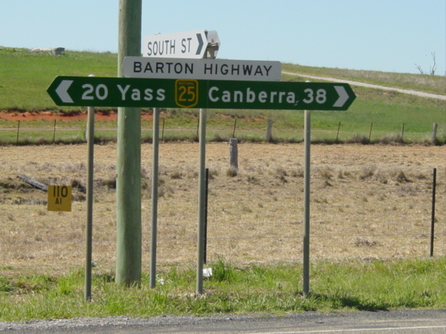
Fingerboard signage on Barton Highway at South St, Murrumbateman, NSW. Jan 2004.
Length: 54km
Route Name: Barton Highway
Northern Terminus: Hume Highway, Yass Bypass
Southern Terminus: Federal Highway & Northbourne Ave, Lyneham
Focal Points: (Goulburn/Gundagai), Yass, Canberra
RTA Internal Classification: State Highway No. 15
Proclaimed a state highway: 1935
Named: August 1954
Route Overview:
Barton Highway is a short north-south highway connecting Canberra to the Hume Hwy at Yass, and is part of the National Highway system being one of the 'Canberra Connectors' which connect Canberra to Melbourne and Sydney via the Hume Hwy. It was proclaimed a state highway in 1935 to service the new Australian Capital Territory being constructed. Previously it had been a trunk road servicing the farms in the area and providing a longer distance link to Boorowa, Cowra, Forbes and Dubbo. In August 1954, State Highway No. 15 was named "Barton Highway" to honour Australia's first Prime Minister, Edmund Barton. Full sealing of the highway was completed in 1960.
The Barton Highway was given the National Route 25 shield in 1956 (four years before its full sealing was completed) and in November 1974 became National Highway 25, legislated as part of the National Highway system as a "Canberra Connector".
The route is all dual carriageway in the ACT, constructed during the 1990's, but is single carriageway through NSW except for a 6km section known as the 'Barton Connector' which joins NH25 to the Hume Hwy on the Yass Bypass. This connector was opened in May 1995 (commenced in April 1993) and replaced a 1km section of single carriageway highway that met the Old Hume Hwy near Cooma Cottage. This old section of the Barton Highway is now known as Kirketon Rd.
Planning for construction of dual carriageways in NSW has been talked about but nothing concrete has been promised as yet.
Inside the Australian Capital Territory, the first section of dual carriageway was opened to traffic in June 1980 bypassing Hall, a village right on the ACT/NSW border. The original alignment of Barton Highway is Victoria Street, a two-lane street that passes right through the centre of the village. Duplication of the highway generally continued southwards through the late 1980s and 1990s, reaching the newly-opened Gungahlin Drive in 1998. A grade-separated interchange was then constructed at this intersection in 2002, as part of the duplication of the final stretch of Barton Highway (Ellenborough St to Federal Hwy).
The final 2km of the Barton Highway, between Ellenborough Street and Federal Highway, was constructed as a two-lane deviation in the late 1970s with federal funding under the National Highway system. Prior to this, the Barton Highway had connected to Northbourne Avenue via what is now Ellenborough Street and Mouat Street. Duplication of this section of the highway was completed in December 2002 and marked the completion of dual carriageway conditions on the Barton Highway within the ACT.
Notable events in the history of NH25-Barton Hwy:
1935 - Proclaimed a State Highway
Aug 1954 - Named Barton Hwy
1956 - Proclaimed and signposted National Route 25
1960 - Fully sealed
1974 - Proclaimed a National Highway
Jun 1980 - Hall Bypass
1990's - Dual carriageways between Hall and Kaleen
May 1995 - 'Barton Connector' opened at Yass Bypass
Dec 2002 - Dual carriageways between Gungahlin Dr and Federal Hwy
Further reading (on-site):
Barton Highway former alignments
Further reading (off-site):
Barton Hwy - Michael Greenslade
Photos of National Highway 25 - Barton Highway |
|
 |
First mention of the Barton Highway interchange, westbound on Hume Highway. Jan 2004. |
 |
New supplementary AD sign westbound on Hume Hwy, with NH25 on a coverplate over an alpha-numeric route marker. Jan 2004. |
 |
Westbound Hume Highway 1km from the Barton Hwy interchange, approaching Mantons Ridge. Jan 2004. |
 |
Eastbound Hume Highway near Yellow Creek Rd - first mention of the Barton Highway interchange. Jan 2005. |
 |
Eastbound Hume Highway 1km from the Barton Highway interchange. Jan 2005. |
 |
ID signs facing northbound traffic at the northern terminus of the Barton Hwy. Feb 2006. |
 |
AD signs advising of the correct lanes to use, northbound on Barton Highway approaching the Hume Highway. Feb 2006. |
 |
Supplementary AD sign northbound on Barton Highway approaching its terminus at the Hume Highway. Feb 2006. |
 |
Barton Highway northbound approaching its terminus at the Hume Highway. Feb 2006. |
 |
The first 9km of the Barton Highway is dual carriageway, heading south from Hume Highway. Feb 2006. |
 |
First distance sign heading south from Hume Highway. I am very disappointed that this sign doesn't include "Yass" as it is signed from the Hume Hwy in both directions! Feb 2006. |
 |
First AD sign southbound on Barton Highway approaching the interchange with Yass Valley Way (old Hume Hwy), near Yass. Feb 2006. |
 |
AD sign westbound on Yass Valley Way approaching Barton Highway. Feb 2006. |
 |
Interesting diagrammatic AD sign eastbound on Yass Valley Way approaching Barton Hwy. Note how the Barton Hwy northbound is signed as "To Hume Hwy/NH31" since once you enter the Barton Hwy you have no choice but to enter the Hume Highway, 3km north of here. Feb 2006. |
 |
Distance sign heading south from Yass Valley Way interchange. Feb 2006. |
 |
Bypassed town AD sign northbound approaching Yass Valley Way. Note that the sign infers that most of the through traffic would be heading to the Hume Highway and towards Gundagai. Jan 2004. |
 |
Still on the dual carriageway section constructed as part of the Yass Bypass project, looking south across the Yass River. Feb 2006. |
 |
Looking south at the end of the dual carriageways and the transition onto the original highway alignment, 9km south of Hume Hwy. Note the concrete strip on the left of the highway, constructed to minimise traffic disruption when future extension of the dual carriageways are constructed. Feb 2006. |
 |
Looking south along an undulating section of the highway, about 2km south of the dual carriageways. Feb 2006. |
 |
Looking south on a recently improved section at McClungs Creek, between the Yass Bypass and Murrumbateman. Feb 2006. |
 |
Extremely rare NH25 trailblazer southbound about 2km north of Murrumbateman. Note the white lettering, which is probably faded yellow paint or screen-print. Feb 2006. |
 |
Distance sign heading north from Murrumbateman. Note the use of "Hume Highway" as a focal point - I would have preferred to see Yass, Boorowa, Harden, Gundagai and Melbourne as the focal points on this sign. Feb 2006. |
 |
Looking south through the tiny town of Murrumbateman. Feb 2006. |
 |
Very clear and concise AD sign southbound approaching Murrumbateman Road in Murrumbateman. Feb 2006. |
 |
Distance sign heading south from Murrumbateman. Feb 2006. |
 |
Looking south to a winery entrance, just south of Murrumbateman. Feb 2006. |
 |
Three-lane section looking south between Murrumbateman and Hall. Feb 2006. |
 |
Picturesque section lined with grape vines, looking south between Murrumbateman and Hall. Feb 2006. |
 |
Looking south, 3km north of Hall, where the dual carriageways begin. Feb 2006. |
 |
The final stretch of undulating single carriageway before the ACT border. Feb 2006. |
 |
Distance sign heading north from the ACT Border at Hall. July 2004. |
 |
Southbound AD sign for Victoria St (old Barton Hwy) at Hall. Note the beginning of the dual carriageways in the middle distance. Feb 2006. |
 |
The beginning of the dual carriageway conditions, just inside the ACT Border. Feb 2006. |
 |
Second southbound AD sign for Victoria St at Hall. Note the extensive use of brown patching, a common sight in the ACT. Feb 2006. |
 |
AD sign southbound on the Hall Bypass section of Barton Highway, approaching Wallaroo Rd. Note this particular sign is solely focused on tourist attractions and has no mention of Canberra/City or any other focal points. This is a fairly common sight on the Barton Hwy in ACT. July 2004. |
 |
Looking south to Halls Creek on the Hall Bypass. July 2004. |
 |
Distance sign heading south from Gladstone St at Hall. July 2004. |
 |
Distance sign heading north from Kuringa Drive. The ACT Government has the right idea here, using Melbourne as the last focal point on the distance sign. July 2004. |
 |
AD sign southbound approaching Kuringa Drive. Note this sign is predominately focused on tourist destinations (Wineries & Lake Ginnindera) so the normal focal points appear on green patches. Feb 2006. |
 |
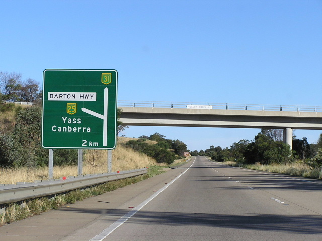
Distance sign heading south from Currans Drive near Gold Creek Village. Feb 2006. |
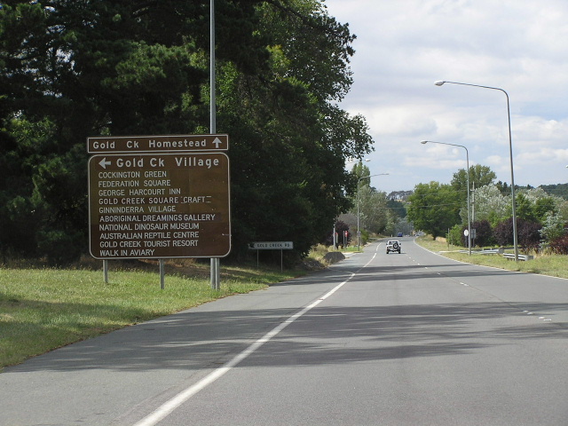 |
Looking south apporoaching Gold Creek Rd. I don't see what use this sign is, since nobody could hope to read even half of the attractions listed on this sign without pulling over. Feb 2006. |
 |
Looking southeast approaching the William Slim Dr/Gundaroo Dr roundabout, located in a 100km/h zone, at Giralang. Feb 2006. |
 |
Distance sign heading northwest from William Slim Dr & Gundaroo Dr. July 2004. |
 |
AD sign southeastbound approaching William Slim Dr & Gundaroo Dr. Feb 2006. |
 |
AD sign posing as an ID sign at the William Slim Dr & Gundaroo Dr roundabout. Note the lack of a NH25 of TD4 shield. Feb 2006. |
 |
Lovely early 1990s ID sign at the William Slim Dr & Gundaroo Dr roundabout. Feb 2006. |
 |
AD sign heading northwest approaching William Slim Dr & Gundaroo Dr. July 2004. |
 |
Looking southeast between Gundaroo Drive and Gungahlin Drive. in the 100km/h zone. Feb 2006. |
 |
Looking southeast to Bellendeen Street which, until the construction of Gungahlin Drive in 1998, was a major turnoff. It is now a dead-end. July 2004. |
 |
Heading southeast approaching the interchange with Gungahlin Drive at Kaleen. Feb 2006. |
 |
Looking southeast at the Gungahlin Drive interchange. I believe the roadworks are for the Gungahlin Drive extension. Feb 2006. |
 |
Incorrect NR25 shield on an AD sign northeastbound approaching Gungahlin Drive. July 2004.. |
 |
Looking south approaching the junction with Ellenborough St (old Barton Highway) at Lyneham. The dual carriageways beyond this sign were completed in December 2002. Feb 2006. |
 |
Looking southeast along the newly-duplicated section near Randwick Road at Lyneham. July 2004. |
 |
Tourist RD sign heading north west in Lyneham. July 2004. |
 |
First distance sign heading northwest on Barton Hwy at Lyneham. The locating of the shield to the left of the focal points is reminiscent of past QMR practice. July 2004. |
 |
Tourist AD sign southbound approaching the junction with Federal Highway (NH23) and Northbourne Ave (NR23) at Lyneham. Note the incorrect NH25 shield - should be NH23. July 2004. |
 |
Newly installed (2004?) truck bypass signage, advising through trucks to the listed destinations to use Federal Highway. July 2004. |
 |
Double-chevron ID sign at the Barton Hwy, Federal Hwy & Northbourne Ave junction. July 2004. |
 |
Southbound on Federal Highway approaching Barton Hwy at Lyneham. July 2004. |
 |
AD sign northbound on Northbourne Ave approaching Barton Hwy at Lyneham. July 2004. |
Back to the National System
Back to NSW Route Numbering
Back to ACT