THE NATIONAL SYSTEM
At the moment, the national system is in a time of change. Tasmania, rural Victoria and South Australia have all replaced the old shielded route numbering system with the new alpha-numeric style. New South Wales, Queensland & Northern Territory are in the progress of converting their shielded routes to alpha-numeric routes. The jury is still out on whether Metroploitan Melbourne, Western Australia and the Australian Capital Territory will conform but according to this release from Austroads; 'In May 1997 Transport Ministers agreed to principles for a national approach to rural route numbering..' Despite all states agreeing to the changes, the standard approach may not be completed across the country for at least 10 years, and for the moment we have a bits and pieces route-numbering system to navigate by. Admittedly, navigation is made easier as the states seem to have agreed on consistent signage across the borders (thank God!) plus or minus the alpha-numeric prefix.
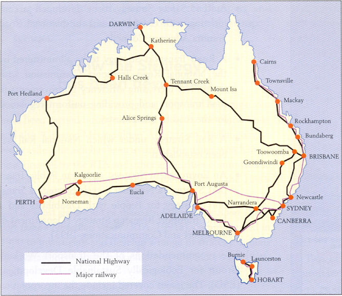
Prior to 1995, the National system of route marking consisted of three tiers. Firstly, the National Route system which was made up of the major interstate highways in Australia and signed with a black and white shield, similar in shape to the shield that appears on the Australian Coat of Arms. This system was introduced in 1954 and new routes have been signed since then to make the complete system we have today. The system was prepared by COSRA (Conference of State Road Authorities), now called Austroads. COSRA prepared the initial plan and then managed the system as NAASRA (National Assosciation of Australian State Road Authorities) until the late 1980's. MOre on the role of NAASRA can be found by following the links below. Closely interwoven with the National Routes is the National Highway system, which is a completely federally funded collection of highways forming the most favourable routes between capital cities (including Cairns and Burnie). These routes are signposted with a green and gold shield of the same shape as the National Route shield. The numbering of these highways is taken directly from the pre-existing National Route system so many of the green and gold routes continue as black and white routes beyond the boundaries of the National Highway system. The second tier was the state routes of the various states (including Northern Territory but excluding Tasmania), carrying the blue shield and forming the major urban and intra-state links, and the Tourist Drives which carry the brown shield and take motorists past recognised tourist destinations. Information on the three tiers can be found by following the links at the bottom of the page.
Now, a new style of route marking is infesting Australian highways. The alpha-numeric style, similar to that used in Britain and across Europe, was adopted in May 1997 by all the state and federal transport ministers as the system for a nationally consistent approach to route numbering. This alpha-numeric system has been installed in several states and others will follow. I have created a page below to showcase the onset of alpha-numeric route numbering across Australia, view it by following the link below.
Explore the National System:
Route Marking:
- Highway One
- National Highways
- National Routes
- State Routes
- Alpha-numeric Routes
Australian Standards in route marking, road design and construction:
- Austroads, NAASRA and COSRA
Federal Road Funding and Legislation:
Currently federal road funding, until June 2005, was administered under the Australian Land Transport Act (1988) and the Roads to Recovery Act (2000). These Acts were replaced by Auslink – a funding program that encompasses major railways and port access routes as well as the former National Highways. David Isaacs has written this article detailing the history of federal road funding from 1974 to present.
- Onward to Auslink: Commonwealth Highway Funding Schemes (written by David Isaacs)