National Route 71
Mitchell Highway
Mitchell Highway
|
|
National Route 71
Mitchell Highway |
|

Typical QLD set up of kilometre plate
and
trailblazer on the former section of NR71, heading south from
Charleville. Photo taken: January 2005.
In 2013, RMS will be implementing a new alpha-numeric route numbering system. For more information, visit the RMS Website. |
|
Forthcoming alpha-numeric route number: |
|
Length: 341km
Northern Terminus: NSW/QLD Border, Barringun
Southern Terminus: Mitchell Hwy (NR32/NR71) & Barrier Hwy (NR32), Nyngan
Route taken: Mitchell Highway
Focal Points: Nyngan, Bourke, Cunnamulla
RTA Internal Classification: Highway No. 7
QDMR Internal Classification: State Highway No. 23
In this section:
National Route 71 is the remnant of a remote north-south route through western NSW and central western QLD. Originally stretching from Nyngan all the way to Barcaldine, the route has, in recent years, been truncated as part of the introduction of alpha-numeric route marking in Queensland. At present, National Route 71 is signposted from the junction of Mitchell and Barrier Highways at Nyngan, via Mitchell Highway to the NSW/QLD border at Barringun.
Early plans for the National Route system saw National Route 71 as north-south route through western NSW and central western QLD, linking a number of east-west highways and forming part of the most direct route between Sydney and Darwin. The first National Route 71 signs were erected in 1960 between Nyngan and Cunnamulla, as an extension to the then recent marking of National Route 32 between Sydney and Nyngan (and on to Adelaide). In 1968, National Route 71 was extended northwards through Charleville, Augathella, Tambo and Blackall to Barcaldine. At the time, the vast majority of the route was unsealed - whilst sealing of Mitchell Highway in NSW was completed during the 1970s, it was not until the late 1980s that the entirity of the route through Queensland was fully sealed.
In 1974, the Landsborough Highway (Augathella-Barcaldine) section of National Route 71 was declared as part of the Brisbane-Darwin link of the former National Highway System. The black-and-white National Route 71 shields were replaced with the new green-and-gold National Highway shields in 1979, following a Federal Government decision to denote the National Highways with the distinctively-coloured shields.
The full extent of the route lasted until 2002 when, as part of the first stage of alpha-numeric route marking in Queensland, the portion of the route between Charleville and Barcaldine was decommissioned. Route A2 replaced NH71 between Augathella and Barcaldine, whilst route Alt-A2 replaced NR71 between Charleville and Augathella. New 'END NR71' signage was erected at the junction of Mitchell Highway & Warrego Highway in Charleville to mark the new northern terminus of the route.
Conversion of the remaining portion of National Route 71 in Queensland to alpha-numeric route marking - route A71 - was commenced late in 2004, with scattered A71 trailblazers evident on a trip along the route in January 2005. However, it was not until May 2007 when the route was properly decommissioned, with the replacement of all NR71 shields with A71.
It is proposed, as part of the introduction of alpha-numeric route marking in New South Wales, to replace the remainder of National Route 71 with route A71. No changeover date has been set, although a large number of signs between Nyngan and Bourke were replaced during late 2008 in anticipation of the changeover.
|
1883
|
-
|
Bridge
over Darling River at North Bourke (replaced 1997)
|
|
1928
|
-
|
Proclaimed
State Highway No. 7 in NSW - named North Western Hwy
|
|
Oct
1936
|
-
|
Named
Mitchell Hwy between Nyngan and Charleville
|
|
1960
|
-
|
NR71
signs erected between Nyngan and Cunnamulla
|
|
1968
|
-
|
NR71
signs erected between Cunnamulla and Barcaldine
|
|
Nov
1972
|
-
|
Sealing
completed in NSW
|
|
Nov
1974
|
-
|
Landsborough
Highway portion of route proclaimed a National Highway
(Augathella-Barcaldine)
|
|
1979
|
-
|
National
Route 71 shields replaced by National Highway 71 shields from
Augathella to Barcaldine
|
|
Late
1980s
|
-
|
Mitchell
Hwy fully sealed in QLD
|
|
Sep
1997
|
-
|
Gateway
Bridge over Darling River, North Bourke
|
|
2002
|
-
|
Route
decommissioned north of Charleville (replaced by NH-A2 and Alt-A2)
|
|
May 2007
|
-
|
Route decommissioned between Charleville and
NSW/QLD Border (replaced by A71)
|
| Further Reading (On-site): | ||
| Mitchell Highway (NSW) | ||
| Mitchell Hwy (QLD) | ||
| Landsborough Hwy | ||
 |
Looking
south at the NSW/QLD Border at Barringun. Note the older (1990s) style
border sign with a newer (September 2003) Tourism NSW sign in the
background. The border marks the
present northern terminus of National Route 71 and the southern
terminus of route A71. |
 |
Mitchell Highway (NR71) looking
south into the tiny village of Barringun, just south of the NSW/QLD
border.
Photo taken: January 2005. |
 |
Typical remote NSW service
signage, southbound on Mitchell Highway (NR71) leaving Barringun.
Photo taken: January 2005. |
 |
Kidman
Way tourist sign, heading south from Barringun. This sign is slightly
deceptive, however, as the Kidman Way does not begin until Bourke.
Source: Nathan Johnston, December 2008. |
 |
Fingerboard sign assembly in the
tiny village of Enngonia, 97km north of Bourke.
Source: Nathan Johnston, December 2008. |
 |
Typical view of Mitchell Highway
(NR71) looking south, south of Engonnia.
Photo taken: January 2005. |
 |
Non-standard fingerboard sign on
Mitchell Highway (NR71) at the Fords Bridge turnoff, 62km north of
Bourke.
Photo taken: January 2005. |
 |
Poorly-designed
fingerboard sign assembly, incorrectly using capital letters and
omitting a NR71 shield, at theturnoff to Lednapper Crossing, 43km north
of Bourke.
Photo taken: January 2005. |
 |
Properly
designed fingerboard sign assembly with one mistake - the NR32 shield
should be a NR71 shield! - at the turnoff to Collerina, 29km north of
Bourke.
Photo taken: January 2005. |
 |
Non-standard,
poorly designed AD sign on Main Road No. 425 (Bourke-Weilmoringle)
approaching Mitchell Highway (NR71), 16km north of Bourke. Note the
incorrect National Highway shield.
Photo taken: January 2005. |
 |
Black AD sign northbound on
Mitchell Highway (NR71) approaching the junction with Main Road No.
425, 16km north of Bourke.
Photo taken: January 2005. |
 |
Typical
remote NSW services signage, northbound on Mitchell Highway (NR71)
leaving North Bourke. The accommodation 250km away is at Cunnamulla,
QLD.
Photo taken: January 2005. |
 |
Non-standard RD sign with peeling
NR71 shield, northbound on Mitchell Highway (NR71) at North Bourke.
Photo taken: January 2005. |
 |
Non-standard
AD sign, missing a NR71 shield, southbound on Mitchell Highway (NR71)
approaching Main Road No. 404 (North Bourke-Hungerford) at North
Bourke. Mitchell Highway and NR71 both make the left turn across the
Darling River towards Bourke.
Photo taken: January 2005. |
 |
Another
non-standard and poorly designed AD sign, this time at least sporting a
NR71 shield, eastbound on M.R. No. 404 approaching Mitchell Highway
(NR71) at North Bourke.
Photo taken: January 2005. |
 |
Looking
east to the original bridge over the Darling River at North Bourke.
Constructed in 1893, this timber bridge with a bascule opening span to
cater for long-dead river traffic carried the Mitchell Highway until
replaced by the adjacent two-lane bridge in 1997.
Photo taken: January 2005. |
 |
A view of the bascule opening
span, taken from a vehicle traversing the current bridge.
Photo taken: January 2005. |
 |
Non-standard RD sign with
illegible NR71 shield, northbound on Mitchell Highway (NR71) leaving
Bourke.
Source: Nathan Johnston, December 2008. |
 |
Poorly
designed AD sign southbound on Mitchell Highway (NR71) approaching the
junction with Kamilaroi Highway (NR37), Bourke. Note the premature
mention of Kidman Way, which does not commence until south of Bourke
town centre.
Source: Richard Wardle, September 2008. |
 |
Poorly-designed
AD sign westbound on Kamilaroi Highway (NR37) approaching the junction
with Mitchell Highway (NR71). Note the incorrect National Route 75
shield!
Photo taken: January 2005. |
 |
Another
poorly-designed sign - this time northbound on Mitchell Highway (NR71)
approaching the intersection with Mitchell St & Richard St.
Mitchell Highway makes the right turn from Richard St onto Mitchell St
at the northern end of Bourke town centre.
Photo taken: January 2005. |
 |
Mitchell Highway (NR71) looking
south along Richard St, through the town centre of Bourke.
Photo taken: January 2005. |
 |
A fantastic relic - black ID sign
at the intersection of Mitchell Highway (NR71), Kidman Way (SR87)
& Anson St, Bourke.
Photo taken: January 2005. |
 |
Perfectly
designed black AD sign westbound on Mitchell Highway (NR71) approaching
the junction with Kidman Way (SR87) & Anson St, Bourke. Note
that
this sign pre-dates to extension of State Route 87 from Hillston to
Bourke and hence is now incorrect.
Photo taken: January 2005. |
 |
Another poorly designed sign -
this time the RD sign heading south on Mitchell Highway (NR71) from
Bourke.
Photo taken: January 2005. |
 |
Mitchell Highway (NR71) northbound
at Coolabah, approaching the junction with Main Road No. 70
(Coolabah-Brewarrina-Goodooga).
Source: Jim Fisher. |
|
|
Top: RD sign on Mitchell Highway (NR71) heading
north-west from Nyngan. Bottom: Replacement RD sign in preparation for
alpha-numeric route marking. |
 |
Mitchell
Highway (NR71) looking south towards the junction with Barrier Highway
(NR32) at Nyngan. Mitchell Highway continues through the intersection
as National Route 32, whilst NR71 terminates here.
Photo taken: September 2006. |
 |
AD sign eastbound on Barrier
Highway (NR32) approaching the junction with Mitchell Highway
(NR32/NR71) at Nyngan.
Photo taken: October 2004. |
 |
ID
sign at the intersection of Barrier Highway (NR32) & Mitchell
Highway (NR71) incorrectly showing a duplex instead of NR71 to the left
and NR32 to the right.
Photo taken: October 2004. |
 |
Mitchell Highway (NR32)
northwestbound approaching the junction with Barrier Highway (NR32) on
the western outskirts of Nyngan.
Photo taken: December 2006. |
|
Section: Barcaldine to Charleville
|
|
 |
The
only remnant of National Highway 71 - AD sign southbound on Dawson
Developmental Rd, approaching Landsborough Highway at Tambo.
Photo taken: January 2005. |
|
Section: Charleville to NSW/QLD Border,
Barringun
|
|
 |
Mitchell Hwy (Alt-A2) southbound
approaching the Warrego Hwy and the beginning of NR71 in Charleville.
Jan 2005.
Photo taken: January 2005. |
 |
Warrego Hwy heading west,
apporoaching the beginning of NR71 at the Mitchell Hwy in Charleville.
Photo taken: January 2005. |
 |
ID signs facing westbound traffic
at the same intersection. Note that Alt-A2 is on a coverplate over
NR71. Jan 2005.
Photo taken: January 2005. |
 |
"End
NR71" trailblazer, northbound on Mitchell Hwy approaching the Warrego
Hwy at Charleville. Note how the Alt-A2 is on a coverplate over
National Route 71 (straight) and State Route 14 (right).
Photo taken: January 2005. |
 |
The first RD sign southbound on Mitchell Highway (former NR71) in
Charleville.
Photo taken: January 2005. |
 |
AD sign westbound on Charleville-Bollon Rd approaching Mitchell Highway (former NR71) in Charleville.
Photo taken: January 2005. |
 |
RD sign southbound on Mitchell Highway (former NR71), heading south from Charleville. Note the unusual use of Barringun instead of Bourke as the remote focal point.
Photo taken: January 2005. |
|
|
Typical QLD set up of kilometre plate and trailblazer on the former section of NR71, heading south 17km from Charleville.
Photo taken: January 2005. |
 |
RD sign northbound on Mitchell Highway (former NR71) leaving Cunnamulla.
Photo taken: January 2005. |
 |
AD sign southbound on Mitchell Highway (former NR71) approaching the junction with Bulloo Developmental Rd (SR49) on the eastern outskirts of Cunnamulla.
Photo taken: January 2005. |
 |
ID sign assembly at the intersection of Mitchell Highway (former NR71) & Bulloo Developmental Rd (SR49), Cunnamulla. State Route 49 continues east along a short section of Mitchell Highway, then via Ballonne Highway to St George and beyond.
Photo taken: January 2005. |
 |
AD sign westbound on Mitchell Highway (former NR71) approaching Bulloo Developmental Rd (SR49), Cunnamulla.
Photo taken: January 2005. |
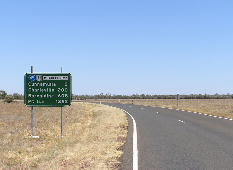 |
RD sign heading east from the junction with Balonne Highway (SR49), 5km east of Cunnamulla. Note the long range focal points of Barcaldine and Mt Isa are not followed up on the RD sign at Cunnamulla.
Photo taken: January 2005. |
 |
AD sign westbound on Balonne Highway (SR49) approaching Mitchell Highway (former NR71), 5km east of Cunnamulla.
Photo taken: January 2005. |
 |
AD sign northbound on Mitchell Highway (former NR71) approaching the junction with Balonne Highway (SR49), 5km east of Cunnamulla.
Photo taken: January 2005. |
 |
RD sign heading south on Mitchell Highway (former NR71), south of the junction with Balonne Highway (SR49). Photo taken: January 2005. |
 |
Typical QLD setup of kilometre plate and trailblazer, this time 78km south of Cunnamulla, approaching the NSW/QLD Border.
|
  |
Top: Northbound RD sign at the NSW/QLD Border, showing National Route 71. Bottom: Northbound RD sign at the NSW/QLD Border
following the conversion of National Route 71 to A71 in Queensland. |
Last updated 13 December 2012 © Ozroads 2003-2012. |
Back to the National System Back to NSW National Routes Back to QLD Decommissioned Routes Back to Mitchell Hwy (NSW) Back to Mitchell Hwy (QLD) |

