MONARO HIGHWAY (NSW)

Monaro Hwy southbound from the intersection with Snowy Mtns Hwy near Nimmitabel. Feb 2006.
Length: 203km
Northern Terminus: NSW/ACT border, 2km south of Williamsdale
Southern Terminus: NSW/VIC border, 43km south of Bombala
Interstate Continuation:
Continues south into Victoria, terminating at the Princes Hwy in Cann River.
Continues north into the ACT at Williamdsdale, terminating unceremoniously at the Sylvia Curley Bridge over the Molonglo River.
Focal Points: Canberra, Cooma, Bombala, (Cann River), Orbost
RTA Internal Classification: State Highway No. 19
Proclaimed a state highway: 25 March 1938
Named: June 1958
Route Overview:
The Monaro Highway forms part of the signposted National Route 23, the major north-south route sandwiched between the coastal escarpment and the Great Dividing Range. Commencing in New South Wales at the ACT border near Williamsdale, the highway heads directly south through undulating-to-hilly farmland alongside the now-disused Queenbeyan-Bombala railway line to Cooma. In Cooma, the highway takes the National Route 18 shield at the Snowy Mountains Highway junction before heading south for another 56km to the MacLaughlin River. Here the National Route 18 departs (following the eastern section of the Snowy Mountains Hwy to Bega) and the road standard drops dramatically for most of the 41km trip into Bombala. South of Bombala the road quality picks up again and the last 13km before the Victorian border are excellent, having been completely reconstructed in 1999.
National Route 23 is the signed, or "operating", route along the length of the Monaro Highway in New South Wales. It is joined by National Route 18 between the north and south junctions with the Snowy Mountains Highway, however the duplex is pretty poorly signed. Signposting of National Route 23 south of the Snowy Mountains Highway is also very poor, with a number of signs outdating the extension of NR23 from Cooma to Bombala (1980s?) and others just simply leaving the shield out. There is also a random National Route 19 shield (19 is the internal number for the Monaro Hwy) south of Bombala - see photos below.
History:
The route of the Monaro Highway was established in 1882 and has since grown into a major road. However, the Monaro did not make the original declaration of State Highways in 1928, instead what became the route of the highway was classified thus: Trunk Road No. 52 (Williamsdale to Cooma), State Highway No. 4 (Cooma to Nimmitabel), Trunk Road No. 53 (Nimmitabel to the Victorian Border at Delegate River via Bombala).
In March 1938, the Department of Main Roads implemented changes brought about by their first review of the declared road network, declaring State Highway No. 19: from the ACT Border near Williamsdale via Michelago and Bredbo to Cooma. Thence from State Highway No. 4 (now Snowy Mountains Hwy) at Nimmitabel via Bombala and Delegate to the Victorian Border at Delegate River. Initially, this new State Highway was unnamed and remained so for two decades.
The name "Monaro Highway" had originally been applied to State Highway No. 4 (current Snowy Mountains Hwy) since 1928, as it connected the Riverina and the coast with the Monaro Plains. However, with the growth of the Snowy Mountains as a tourist destination and the commencement of the massive Snowy Mountains Hydro-Electric Scheme in 1949, the Department of Main Roads decided it was appropriate the rename State Highway No. 4 "Snowy Mountains Highway" and use the Monaro Highway name for State Highway No. 19, the entire length of which was located in the Monaro Plains region. The change of name for State Highway No. 4 was gazetted on 9 September 1955 and by proclamation in the same gazette the length of State Highway No. 4 between Cooma and Nimmitabel was redeclared part of State Highway No. 19. After a three-year grace period (to minimise confusion with the highway name change), State Highway No. 19 was officially gazetted as the "Monaro Highway" on 27 June 1958.
At this stage, the Monaro Highway commenced at the ACT Border near Williamsdale, running south via Cooma, Nimmitabel, MacLaughlin, Bombala and Delegate to the Victorian Border at Delegate River. Two more important events would transform the highway into the route we know today. The first was the construction of a deviation from 1-11km south of Nimmitabel which involved realigning the existing Snowy Mountains Highway, construction of a 1km connection between the existing Monaro Hwy and the Snowy Mtns Hwy, and the construction of a new concrete bridge over the MacLaughlin River. This deviation, opened in December 1968, meant a 9km section of narrow, winding road with two timber bridges and two railway crossings was eliminated. The gazetted description of the Monaro Hwy was thus changed slightly, to incorporate the deviation and a section of former State Highway No. 4.
The second major change came on 2 December 1977, the route of the Monaro Highway been changed south of Bombala. Initially, the Monaro Highway had reached the Victorian border via Delegate, linking with the Victorian State Highway system by way of the Bonang Highway. This had been the appropriate routing at the time, but the declaration of the Cann Valley Highway in Victoria during the 1960s reflected changing travel patterns. Traffic heading to/from Orbost now preferred the newly-sealed Princes Highway and partly-sealed Cann Valley Highway route as it had easier grades and a much higher speed alignment than more remote the Bonang Highway, which was unsealed from Orbost to the NSW Border. The declaration on 2 December 1977 re-routed the Monaro Highway onto what was formerly Main Road No. 288 (Bombala-Rockton), meeting the Cann Valley Hwy at the Victorian Border and thus creating the Monaro Hwy as we know it today.
National Route 23 was signposted onto the Canberra-Cooma section of Monaro Hwy in 1962 and signage was extended south to the Snowy Mountains Hwy junction near Nimmitabel in 1967. In the early 1990's NR23 was signposted as far south as Bombala, with the final stretch getting shields in August 1999 when the last unsealed section was bypassed. NR23 used to continue south along the Monaro Hwy into Victoria but now terminates at the border as of 2001.
Notable events in the history of NR23 - Monaro Hwy:
1882 - Monaro Hwy route established
1930 - Current Monaro Hwy route south of Bombala via Rockton to Cann River constructed
March 1938 - Proclaimed State Highway No. 19 (ACT to Cooma & Snowy Mtns Hwy to VIC Border via Delegate)
9 Sep 1955 - Snowy Mtns Hwy duplex regazetted as part of State Highway No. 19
1959 - Bunyan Deviation (replaced 2 level crossings and circuitous route through Chakola)
27 June 1958 - Named Monaro Hwy
1962 - NR23 signposted between Canberra and Cooma
1967 - NR23 signage extended south to Nimmitabel
Dec 1968 - Nimmitabel to Tea Gardens deviation (replaced timber bridge across McLaughlin River and 2 level crossings)
1969 - Flat Rock Deviation (9.2-12.4mi south of Cooma)
March 1974 - Bredbo Deviation
Dec 1977 - Route changed south of Bombala (to Cann River rather than Delegate)
1986 - New concrete bridge over Numeralla River (replaced timber bridge)
1990's - NR23 signposted as far south as Bombala
Aug 1992 - Reconstruction 32-37km south of Bombala including new bridge over Hopping Joe Creek
Dec 1997 - Bridge over Bombala River, Bibbenluke (replaced last timber bridge on highway)
November 1999 - Last unsealed section reconstructed and sealed, NR23 signposted to Victoria
Further Reading (on-site):
Monaro Hwy (ACT)
Former Alignment: Nimmitabel to Tea Gardens
Former Alignment: Bombala to Delegate
Monaro Highway (VIC)
Further Reading (off-site):
Monaro Hwy - Michael Greenslade
Photos of Monaro Highway |
|
 |
Looking south at the ACT/NSW border, without any acknowledgement that you are entering NSW! April 2005. |
 |
Distance sign heading south from the ACT/NSW border near Williamsdale. Only the intrepid roadgeek would know that a random distance sign in the middle of nowhere equates the crossing of the border. Feb 2006. |
 |
Southbound approaching Michelago. Apr 2005. |
 |
Entering the Snowy Mountains tourist region, southbound between Michelago and Colinton. Apr 2005. |
 |
Looking south towards the rest area at Colinton. Feb 2006. |
 |
Distance sign heading north from Bredbo. Feb 2006. |
 |
Looking south through the small township of Bredbo. Feb 2006. |
 |
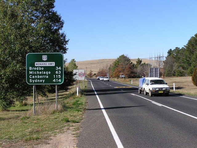
Distance sign heading south from Bredbo - unusual that Tumut gets a mention, I doubt there would be much traffic heading towards Tumut from here. Feb 2006. |
 |
Fantastic view looking south between Bredbo and Bunyan. Apr 2005. |
 |
Another view of the hilly terrain approaching Cooma. Feb 2006. |
 |
Distance sign heading north from Cooma. Apr 2005. |
 |
Heading south on Sharp St n Cooma, approaching the junction with Snowy Mountains Highway (also Sharp St). Note the missing NR18 shield (left). Feb 2006. |
 |
Looking north along Sharp St (Monaro Hwy) from Bombala St (also Monaro Hwy). Feb 2006. |
 |
ID sign at the Snowy Mountains Highway junction in Cooma. Note the missing NR23 shield. Feb 2006. |
 |
AD sign on Monaro Hwy (Bombala St), heading north-west approaching the junction with Snowy Mountains Hwy (Sharp St) in Cooma. Feb 2006. |
 |
Very old black fingerboard sign with only a NR18 shield at Campbell St in Cooma. Feb 2006. |
 |
Distance sign heading southeast from Cooma with the bridge over the now disused Queenbeyan-Bombala rail line. Feb 2006. |
 |
Looking south to Rock Flat Creek. Feb 2006. |
 |
Distance sign heading north from Nimmitabel. Note the missing NR18 shield. Feb 2006. |
 |
Looking south through the small town of Nimmitabel. Feb 2006. |
 |
Old black AD sign approaching Monaro Hwy from Clarke Street. Note the missing NR23 shield. Feb 2006. |
 |
Old Department of Main Roads signage for the old Nimmitabel Sub-Depot, just off the Monaro Highway in Mason St, Nimmitabel. May 2006. (Ben Johnson) |
 |
Distance sign heading south from Nimmitabel. Feb 2006. |
Click HERE for photos of the old alignment of the Monaro Hwy between Nimmitabel and Tea Gardens |
|
 |
Distance sign heading north from Snowy Mountains Hwy. Apr 2005. |
 |
Southbound AD sign approaching the junction with Snowy Mountains Hwy. Note the coverplates over (presumably) alpha-numeric route markers. Feb 2006. |
 |
ID sign assembly at the Snowy Mountains Hwy junction. Note the missing NR18 shield (left) and the missing NR23 shield (top). Feb 2006. |
|
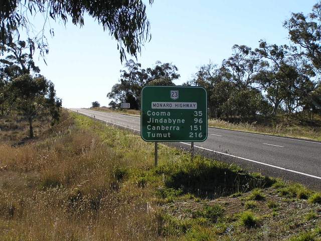
Distance sign heading south from Snowy Mountains Hwy. Feb 2006. |
 |
Looking north between Snowy Mountains Hwy and Old Bombala Rd. Feb 2006. |
 |
Old black AD sign on the road from Dalgety approaching NR23. This sign definately outdates NR23 on this road. July 2005. |
 |
Looking south along a former alignment at the Bombala River crossing, Bibbenluke. July 2005. |
 |
Looking north between Bombala and Bibbenluke. As you can see the Monaro is now of excellent standard. July 2005. |
 |
Northbound distance sign leaving Bombala, adjacent to the old railway station. July 2005. |
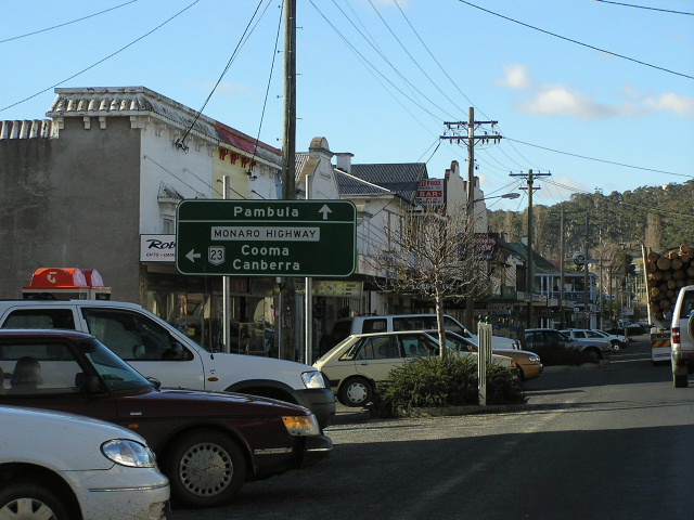 |
Northbound in Bombala at the Pambula turnoff. July 2005. |
 |
ID sign at the Pambula turnoff in Bombala. Note the lack of a NR23 shield and the incorrect focal point of 'Cann River'. My guess is that Cann River used to be the focal point for this section of highway but has been changed to 'Orbost'. July 2005. |
 |
ID sign in Bombala. Note that this sign is the same age as the one above but this one includes the NR23 shield. Perhaps NR23 was signed as far south as Bombala before being extended to Cann River in 199 when that section was fully sealed. July 2005. |
 |
Southbound leaving Bombala. Note no NR23 shield and no highway name. Because of this, the sign doesnt really specify whether the distances to Orbost and Melbourne are via Cann River or the shorter Delegate Rd. July 2005. |
 |
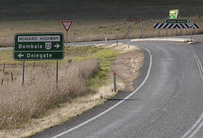
AD sign southbound approaching Delegate Rd. Note the lack of a NR23 shield left. July 2005. |
 |
Northbound distance sign, same intersection. Note the lack of NR23 shield or highway name. July 2005. |
 |
Fantastic relic, possibly pre-dating the Decmeber 1977 redeclaration of the highway. July 2005. |
Click HERE for former alignment of Monaro Hwy from Bombala to Delegate River |
|
 |
ID sign at the Delegate Rd intersection. This sign also has a NR23 shield! July 2005. |
 |
Northbound Monaro Hwy approaching Delegate Rd. Note this sign has a NR23 shield. Strange..... July 2005. |
 |
Southbound distance sign from Delegate Rd. Again, no NR23 shield. July 2005. |
 |
Southbound approaching Imlay Rd. July 2005. |
 |
Fingerboard sign at Imlay Rd. Note the incorrect NR19 shield. The sign designer must have mistaken the highways 'State Highway 19' designation for its route number, NR23. July 2005. |
 |
Southbound across the Genoa River, showing the newly upgraded section and the old pavement off to the left. July 2005. |
  |
Old and new border signs at the southern terminus of NR23. The Monaro Hwy continues south into Victoria as the B23 to terminate at the Princes Hwy, Cann River, where NR23 once terminated. July 2005. |
 |
Northbound distance sign from the state border. July 2005. |