Metroad 2 Sydney to Windsor |
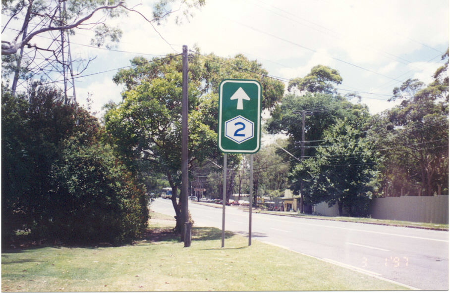
Trailblazer on Castle Hill Rd (former Metroad 2) at West Pennant Hills. Jan 1997.
In 2013, RMS will be implementing a new alpha-numeric route numbering system. For more information, visit the RMS Website. |
|
Forthcoming alpha-numeric route number: |
|
Length: 53km
Eastern Terminus: Pacific Highway & Gore Hill Freeway & Longueville Rd, Lane Cove
Western Terminus: Bridge St & Macquarie St, Windsor
Route taken: Lane Cove Tunnel, Hills Motorway, Old Windsor Rd, Windsor Rd, Bridge St
Focal Points: Sydney, Epping, Parramatta (eb only), Seven Hills, Windsor
RTA Internal Classification: Freeway No. 6002 (Lane Cove Tunnel + Hills Motorway), Main Road No. 635 (Old Windsor Rd), Main Road No. 184 (Windsor Rd & Bridge St)
Route Overview:
Metroad 2 is the major route from Sydney to the north-western suburbs, stretching from Metroad 1 (Pacific Hwy/Gore Hill Fwy) at Lane Cove to Metroad 9 (Macquarie St) at Windsor. Following extensive upgrading through the late 1990s and early 21st century the route at least four lanes wide for most of its length. Between its eastern terminus and Bella Vista - a distance of approximately 30km - it is of motorway-standard.
Metroad 2 was introduced in November 1993, the last of a series of six Metroad routes that were introduced by the RTA during 1992 and 1993. Its original route, while serving the same purpose as it currently does, was markedly different to the current route. Upon introduction, Metroad 2 began at Cleveland Street in Chippendale, following Wattle and Fig Streets (southbound traffic used Harris and Regent Streets), the Western Distributor, Bradfield Highway, Warringah Freeway, Gore Hill Freeway, Longueville Rd, Epping Rd, Beecroft Rd, Pennant Hills Rd, Castle Hill Rd, Old Northern Rd, Showground Rd and Windsor Rd, terminating at the intersection of Bridge and Macquarie Streets in Windsor. Despite this being cited by the RTA as the official route of Metroad 2, signs south of the Bradfield Highway never recognised the Metroad 2 shield, instead showing "To Metroad 1" or just referring simply to the Harbour Bridge.
The first change to Metroad 2's route came in May 1997 with the opening of the Hills (M2) Motorway between North Ryde and Seven Hills. Metroad 2 was re-routed onto the new motorway, and then Old Windsor Road, rejoining Windsor Road at Kellyville. Metroad 2 signs disappeared from the old alignment very quickly and there are no remnants left today.
The second change came in December 2005 with the opening of the Westlink M7 motorway, which took Metroad 2 for its first 1km or so, allowing traffic to bypass the section of Old Windsor Road between Abott and Seven Hills Roads. However, signage installed after opening was typically incoherent and in fact show Metroad 2 using both the new motorway and the Old Windsor Road route.
The third change to Metroad 2 came in June 2006 when, as part of the Lane Cove Tunnel construction works, the loop ramp from Longueville Road to Pacific Highway was closed to traffic. This necessitated some signage changes and, perhaps coincidentally, Metroad 2 was truncated at the intersection of Pacific Highway & Longueville Road, Lane Cove. Most signs disappeared within a few days however there are still a few Metroad 2 shields hanging around on/adjacent to the Gore Hill & Warringah Freeways.
The fourth and final change came with the opening of the Lane Cove Tunnel in December 2006. The former route along Epping and Longueville Roads was replaced by the new route through the tunnel.
For more information on the former alignments of Metroad 2 see below.
Notable events in the history of Metroad 2:
1974 - State Routes 28,30 & 40 introduced - covering most of the current route
Nov 1993 - Route introduced (via Epping, Beecroft, Castle Hill, Old Northern and Showground Roads); SR28 & SR30 decommissioned
May 1997 - Hills Motorway opened to traffic - Metroad 2 re-routed onto motorway
Dec 2005 - Re-routed between end of M2 and Old Windsor Rd/M7 junction
June 2006 - Metroad 2 truncated at Lane Cove
March 2007 - Re-routed from Epping and Longueville Roads into Lane Cove Tunnel
Explore Metroad 2: Follow the links below to explore Metroad 2
Eastern Terminus - Pacific Hwy & Gore Hill Fwy & Longueville Rd, Lane Cove
Hills Motorway - photos and information
Former Alignment: Sydney CBD to Lane Cove
Former Alignment: Lane Cove to North Ryde
Former Alignment: North Ryde to Kellyville
Former Alignment: Seven Hills
History of Old Windsor Rd/Windsor Rd
Old Windsor Road historic sections
Windsor Road historic sections
Photos of Metroad 2 (more photos available by following the above links) |
|
Photos of the Lane Cove Tunnel to come soon! |
|
 |
The opening stretch of the M2 Motorway, looking west. This section is located in a trench between the two carriageways of Epping Road. March 2006. |
 |
The first westbound distance sign on the motorway. It is unusual that Beecroft is preferred over another destination (such as Windsor) that is more important. April 2005. |
 |
Lane allocation AD sign westbound on Dehli Road approaching the M2 at North Ryde. June 2006. |
 |
Distance sign for eastbound traffic as you pass under Dehli Road at North Ryde. Jan 2006. |
 |
Heading south through Macquarie Park (North Ryde) approaching Dehli Road, which is the last eastbound exit on the M2. Traffic must also use Dehli Road to reach Mowbray Road, as the M2 merges into the centre of Epping Road. Jan 2006. |
 |
Distance sign heading north from Dehli Road. Now that there is no height clearance to worry about, Windsor has been added as the final focal point. Note how Pennant Hills Rd now has Metroad 6 shield as well as a Metroad 7 shield. Jan 2006. |
 |
Lane Cove Road northbound approaching the M2 interchange at Macquarie Park (North Ryde). Dec 2005. |
 |
Lane Cove Road southbound approaching the M2 interchange at Macquarie Park (North Ryde). Note the additional Sydney sign - traffic cannot access the M2 eastbound here, instead they must use Lane Cove and Epping Roads through North Ryde. May 2004. |
 |
Eastbound AD sign for Lane Cove Road interchange at Macquarie Park (North Ryde). Note the ridiculously small "Sydney Olympic Park" legend. Jan 2006. |
 |
Looking east from the Christie Road overpass at Macquarie Park, showing the ramp from Herring Road onto the westbound M2 Motorway. Note the blue sign which is little more than advertising for a ROAM E-tag. June 2006. |
 |
ID signs at the intersection of Talavera & Herring Roads, Macquarie Park, which is the commencement of the Herring Road on-ramp onto the M2 Motorway. June 2006. |
 |
Toll charges and e-tag signage for the M2 toll booths on the Herring Rd on-ramp at Macquarie Park. June 2006. |
 |
Looking east from the Culloden Rd overpass at Macquarie Park, showing the M2 toll booths, complete with express lanes (E-tag only) that were completed in about February 2006. June 2006. |
 |
Westbound AD sign for the Beecroft Rd interchange, just before you cross Terrys Creek into North Epping. Jan 2006. |
 |
Looking east into the Epping Tunnel. Jan 2006. |
 |
Distance sign heading west at the Beecroft Road interchange. It is unusual that this sign is located before the Beecroft Road overpass, however there is no westbound on-ramp so I guess it doesn't matter. Jan 2006. |
 |
Beecroft Rd southbound approaching the M2 interchange at Cheltenham. May 2004. |
 |
Looking east to the Beecroft Road interchange, showing the bus only lanes leave the motorway bound for Epping Railway Station. Jan 2006. |
 |
The first mention of Pennant Hills Road interchange, westbound at the Kent St footbridge. Note that Liverpool and Canberra have both been coverplated since the opening of the Westlink M7. Jan 2006. |
 |
Very large distance sign heading east from the Pennant Hills Road interchange. Jan 2006. |
 |
The first diagrammatic AD sign for Pennant Hills Road interchange. Note the M7 route marker, which has been signed along the M2 west of Pennant Hills Rd. Jan 2006. |
 |
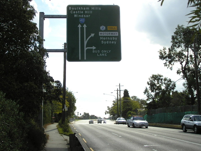
ID sign at the Pennant Hills Rd interchange showing the Metroad 2/M7 duplex. Also note the new remote focal point of Canberra! March 2006. |
 |
AD sign southbound on Pennant Hills Road approaching the M2 interchange. Note that Liverpool is signed straight ahead and there is no mention of Canberra or route M7 for the right turn! Not happy RTA! March 2006. |
 |
Looking west from the Pennant Hills Road overpass, showing the toll booths for the west-facing ramps. March 2006. |
 |
Eastbound AD sign for the Pennant Hills Road interchange. This is the northern terminus of route M7, as well as the northern terminus of Metroad 6 and the southern terminus of Metroad 6! Jan 2006. |
 |
The first westbound AD sign for the Windsor Road interchange at Baulkham Hills. Note that Windsor is now signed straight, formerly it was signed via Windsor Road (because Old Windsor Road still had a load limit north of Sunnyholt Rd). Jan 2006. |
 |
Looking west to the Windsor Road interchange at Baulkham Hills. Note the centre ramp which allows buses to direct access to/from Windsor Road. This is also the western extremity of the bus lanes, which merge into general traffic just beyond the overpass. Jan 2006. |
 |
Distance sign heading west from the Windsor Road interchange. Note the gluttony of route markers on this sign! Jan 2006. |
 |
AD sign northbound on Windsor Road approaching the M2 interchange. Unfortunately this was the best shot I could manage with the sun directly behind the signface. May 2006. |
 |
This is the first of the M7 signage, westbound between Watkins Rd and Cropley Dr, Baulkham Hills. Now that the M7 has been opened, motorists have so mnay choices of where to exit to reach Blacktown! Jan 2006. |
 |
Looking east between Cropley Dr and Watkins Rd at Baulkham Hills. For some reason the M2 has been squashed into a narrow reservation between Windsor Road and Toongabbie Creek, with the result that there are no bus lanes and no room for widening! Jan 2006. |
 |
The last westbound distance sign on the M2 Motorway, nice and simple. Jan 2006. |
  |
This is the first mention of the Abbott Road exit, which is the terminus of the M2 Motorway. Straight ahead the Westlink M7 beckons. Note that Metroad 2 is signed both straight ahead and left - this is because M2 is under the top coverplate and A40 is under the lower coverplate. For now, it makes an interesting little triangle at between Old Windsor Road, the Westlink M7 and Abbott Road.
Jan 2006. The same sign, following coverplating during mid-2006. Now we have no mention of Metroad 2, instead having a blatantly incorrect SR40 shield and silly E-toll symbols covering what once was a Metroad 2 shield. Sigh...how hard is it to get it right? Nov 2006. |
 |
A cantilvered sign warning westbound M2 traffic that Abbott Road is the last exit before the Westlink M7 (and thus another toll) begins. Jan 2006. |
 |
The second diagrammatic AD sign for the Abbott Road interchange. As you can see, Windsor is signed straight ahead (Old Windsor Rd northbound can be accessed via the M7) - I fancy plenty of motorists will exit here though to save an extra 50 cents. Jan 2006. |
 |
Poor angle on this photo, showing the first eastbound distance sign on the M2 Motorway. This sign used to be located on the mainline mtoroway, but as part of the construction of the M7 it has since become an on-ramp. Thankfully there is a distance sign about 1km earlier for Westlink M7 traffic. Jan 2006. |
 |
ID signs at the junction of Old Windsor Rd and Abbott Road, pointing to the entrance to the M2 Motorway. March 2006. |
 |
Distance sign heading south on the Westlink M7 between Seven Hills Road and Abbott Road. The bridge in the distance carries the eastbound on-ramp from Abbott Road and also marks the end of the Westlink M7/start of the Hills (M2) Motorway. Jan 2006. |
 |
Hmmm...what, Metroad 2 ends? No, not really - this sign is incorrect. It will one day say "END M2" (because Old Windsor Rd is A2) but for now this dodgy coverplating job has left a blatantly incorrect sign. Located north-west bound on the Westlink M7 just north of Seven Hills Rd. Nov 2006. |
 |
Somewhat confusing sign, eastbound on the Westlink M7 just before Seven Hills Rd. I think it is trying to tell us that this is the beginning of the Metroad 2/M7 duplex but that is not very clear - it reads as if this is the beginning of both routes. Jan 2006. |
 |
ID sign for Old Windsor Rd exit on the Westlink M7. This sign is perfectly correct now, but what will happen when alpha-numeric route markers are introduced and route A40 is also accessed via this exit? Nov 2006. |
 |
AD sign southbound on Old Windsor Rd approaching the Westlink M7. This sign needs to make up its mind which way Metroad 2 goes! The top Metroad 2 shield is covering an "A40" route marker - to see a photo of it click HERE. Jan 2006. |
 |
Looking south along Old Windsor Road towards Seven Hills Road, prior to the construction of the Westlink M7. This is the location of the M7/Old Windsor Rd interchange. Jan 2004. |
 |
Looking north along Old Windsor Rd towards the junction with Norwest Boulevard and Meurants Lane, Bella Vista. Mar 2005. |
 |
Fast-forward a year and this is the same view, with construction of a four-lane underpass for Old Windsor Rd traffic underway. You can no longer access Meurants Lane from Old Windsor Rd. Jan 2006. |
 |
AD sign assembly northbound on Old Windsor Road approaching the newly-opened underpass at Norwest Boulevard. Note the A2 shield, which is what will replace Metroad 2 when the alpha-numeric system is rolled out (motorway sections of Metroad 2 will get the M2 shield). Sep 2006. |
 |
Looking north to the underpass at Norwest Boulevard. Sep 2006. |
 |
AD sign eastbound on Norwest Boulevard approaching the junction with Old Windsor Rd at Bella Vista. March 2006. |
 |
AD sign southbound on Old Windsor Rd approaching the underpass at Norwest Boulevard. Nov 2006. |
 |
Looking south along Old Windsor Rd at Celebration Drive (it is Drive, despite what the road name plate on the signal mast arm says!). Note the bus priority - I travel Old Windsor Rd frequently and am yet to see an in-service bus use these! March 2005. |
 |
AD sign eastbound on Sunnyholt Rd approaching the junction with Old Windsor Rd at Parklea. March 2006. |
 |
AD sign southbound on Old Windsor Rd approaching the junction with Sunnyholt Rd & Burns Rd at Parklea. March 2006. |
 |
Looking north to Samantha Riley Drive and Newbury Ave. Oct 2005. |
 |
ID sign at the intersection of Old Windsor Rd & Samantha Riley Dr, Kellyville. March 2005. |
 |
Distance sign, heading south on Old Windsor Rd from the junction with Windsor Rd at Kellyville Ridge. May 2005. |
 |
Windsor Rd westbound approaching the junction with Old Windsor Rd at Kellyville Ridge. This junction was reconstructed in 2001-02 from favouring Windsor Rd traffic to favouring Old Windsor Rd traffic, as Old Windsor Rd has once again become the major Parramatta-Windsor route. From this intersection, Metroad 2 duplexes with State Route 40 all the way to Windsor. March 2006. |
 |
Southbound AD sign on Windsor Rd approaching the Metroad 2/State Route 40 split at Kellyville Ridge. Note how Parramatta is signed via Windsor Rd, yet Sydney is signed via Old Windsor Rd! May 2005. |
 |
Looking north along Windsor Rd at Merriville Rd, Kellyville Ridge. The construction of the Parramatta-Rouse Hill Transitway can be seen on the right. March 2006. |
 |
Very undersized double-chevron ID sign showing the Metroad 2/SR40 duplex at Schofields Rd, Rouse Hill. This sign dates from prior to the duplication of Windsor Rd and, whilst it was of adequate size for the old rural T-junction, it is now way too small to be of any use at the current multi-lane intersection. March 2005. |
 |
Metroad 2/State Route 40 trailblazer southeastbound on Windsor Rd approaching Rouse Hill Town Centre. This photo shows duplication work underway in January 2004. |
 |
Looking west to the crossing of Second Ponds Creek at Rouse Hill. Windsor Rd is being deviated at this location to avoid a very narrow cutting between Rouse Hill Estate and former Primary School, as well as to preserve the heritage value of the estate. Oct 2005. |
 |
Looking northwest along Windsor Rd towards the junction with Annangrove Rd and the narrow cutting between the former Route Hill Primary School and Rosue Hill Estate. March 2006. |
 |
Double-chevron ID sign at the junction with Annangrove Rd, Rouse Hill. This section of Windsor Rd is currently being bypassed. March 2006. |
 |
Metroad 2/State Route 40 trailblazer northwestbound at Guntawong Rd, Rouse Hill. April 2005. |
 |
Looking northwest towards Nelson Rd at Box Hill, shwoing duplication and realignment work underway. Oct 2005. |
 |
Similar view, a bit closer to Nelson Rd, prior to the commencement of the roadworks. April 2005. |
 |
Distance sign heading southeast from Alan Street at Box Hill. March 2005. |
 |
Looking northeast along Garfield Rd East, approaching Windsor Rd at Box Hill. As you can see, Garfield Rd East is being realigned to join directly onto Terry Rd, making a four-way signalised intersection with Windsor Rd. March 2006. |
 |
Windsor Rd heading northwest towards Garfield Rd East at Box Hill. This cutting has since been obliterated as part of the realignment and duplication of Windsor Rd, which will improve the grade. March 2004. |
 |
Looking east on Windsor Rd towards Garfield Rd East, showing the obliterated cutting and the realignment works well underway. April 2006. |
 |
Looking west from Garfield Road East at Box Hill, prior to the commencement of upgrading. April 2005. |
 |
A similar view, this time closer to the RD sign, showing duplication and realignment works underway. Also note the surprising inclusion of Kurrajong, rather than Lithgow or McGraths Hill (the latter was shown on all previous distance signs since Northmead) as a focal point. Oct 2005. |
 |
Looking west on Windsor Rd approaching the crossing of First Ponds Creek at Box Hill. Note the overtaking lane, a rarity that was installed during the late 1980s as traffic volumes rose. Jan 2004. |
 |
Very old, probably dating from 1974, fingerboard signs at the intersection of Windsor Rd & Junction Rd, Box Hill. These will probably be removed as part of the duplication works. Jan 2004. |
 |
Metroad 2/State Route 40 trailblazer eastbound between Boundary Rd & Junction Rd, Box Hill. March 2006. |
 |
Very old "P25" kilometre plate eastbound near Boundary Rd , Box Hill. This sign has since been removed during the realignment and duplication works. Jan 2004. |
 |
Looking northwest at Otago Street, Vineyard, showing duplication and realignment works underway. Oct 2005. |
 |
Very old "W5" kilometre plate northwestbound on Windsor Rd near Bandon Rd, Vineyard. This relic has since been removed during the duplication and realignment works. Jan 2004. |
 |
ID signs acting as fingerboards assembly at the junction of Windsor Rd and Bandon Rd, Vineyard. These signs have been removed as part of the duplication and realignment works but will probably be reinstalled when the works are completed. Jan 2004. |
 |
Looking southeast along Windsor Rd between Bandon Rd and Level Crossing Rd, Vineyard, showing duplication work underway. March 2006. |
 |
Looking southeast along Windsor Rd near Latona Ave showing duplication work underway. Jan 2004. |
 |
Looking southeast along Windsor Rd to Park Rd, Vineyard, showing completed duplication work. March 2006. |
 |
Double-chevron ID sign showing an incorrect SR184 marker (Windsor Road's internal classification is Main Road No. 184, hence the confusion) at the junction with Curtis Rd, Mulgrave. March 2006. |
 |
Unusual sign southeastbound on Windsor Rd approaching Curtis Rd, Mulgrave. One of these signs has been installed on every major road leaving the Windsor/Richmond district - these have been designated Flood Evactuation Routes. March 2006. |
 |
Similar southeasterly view showing duplication work underway. Jan 2004. |
 |
Distance sign heading southeast from Mulgrave Rd, Mulgrave. March 2006. |
 |
Very extensive double-chevron ID sign, which I find unusual for such a minor side road (Mulgrave Rd) at Mulgrave. March 2006. |
 |
Looking northwest towards Mulgrave Rd (and Pitt Town Rd) at Mulgrave. Note the four-lane Windsor Rd is undivided at this point, and there is a curving pedestrian/cycling path within the wide road reserve. March 2006. |
 |
Pitt Town Rd heading southwest towards Windsor Road, McGraths Hill. April 2005. |
 |
Looking west from Pitt Town Rd across the South Creek floodplain. April 2005. |
 |
Metroad 2/State Route 40 trailblazer looking west across the South Creek floodplain at McGraths Hill. The problem of Windsor Rd flooding in this location is to be solved by the construction of a flood-free route across South Creek from Richmond Rd to Mulgrave Rd. Oct 2005. |
 |
The first distance sign on Metroad 2 (and the last on Tourist Drive 14), heading eastbound across the South Creek floodplain at McGraths Hill. April 2006. |
 |
The sign signalling the beginning of Metroad 2, on the southeastern abutment of the Fitzroy Bridge over South Creek. This terminus was created in 1993, when Metroad 2 was first signed, and represented the limits of urban Sydney (and thus the Metroad system). However, when Metroad 9 was introduced it would have made sense to extend Metroad 2 the extra 400m to meet Metroad 9 at the junction of Bridge St & Macquarie St, Windsor. I suppose it could be concluded that Metroad 2 actually does terminate at the aformentioned junction as END/START signs are often located on the approaches to the intersection, rather than right at it. April 2006. |
 |
The END Metroad 2 sign, westbound at Fitzroy St. The AD sign for the Bridge St/Macquarie St junction is located just to the left of the photo. April 2006. |
 |
ID sign assemblies at the junction of Bridge St & Macquarie St in Windsor. Note how the ID sign refers to "Start Metroad 2" rather than just showing the route shield - this is certainly the only place I have seen this in NSW. March 2005. |
 |
AD sign southeastbound on Bridge St (State Route 69) approaching Macquarie St at Windsor. The Metroad 2/SR40 duplex begins here, as does the Metroad 9/SR40 duplex - which extends southwest along Macquarie St as far as Richmond Rd. March 2005. |
Last updated 12 December 2012 © Ozroads 2003-2012. |