New South Wales - Major Construction Projects
The purpose of this page is to illustrate construction progress on a variety of major projects which are underway in New South Wales. It will be updated periodically as new photos are submitted. If you'd like to submit some photos for this section please email me.
Projects:
Project Information: http://www.rta.nsw.gov.au/roadprojects/projects/the_hunter_region/hunter_expressway/index.html
The Hunter Expressway is a 40km long dual carriageway, grade-separated road extending from the Sydney-Newcastle Freeway/Newcastle Link Road junction at Cameron Park to the New England Highway west of Branxton. It is intended as a bypass for the existing New England Highway between Beresfield and Branxton, removing through traffic from towns such as Greta and Lochinvar, and relieving traffic congestion in the Maitland urban area.
Construction commenced in August 2010 and is due for completion by the end of 2013, weather permitting. The eastern section, from Cameron Park to John Renshaw Drive at Buchanan, contains some spectacular cuts, fills and bridges as it climbs the Sugarloaf Range. Unfortunately this section is inaccessible to all but the more adventurous in a 4WD, on a trailbike or on foot.
Photos - June/July 2012
|
John Renshaw Drive (Buchanan) interchange |
|
 |
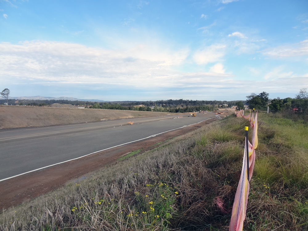
Looking southwest on John Renshaw Drive towards the interchange. The formation branching off to the right is the deviation of John Renshaw Drive which will connect to the roundabout. Source: Peter Renshaw, June 2012. |
 |
Looking south along the mainline from John Renshaw Drive. Source: Peter Renshaw, June 2012. |
 |
Looking southwest at the junction of John Renshaw Drive & Buchanan Road. This intersection will be obliterated once the elevated roundabout is opened to traffic in August. Source: Peter Renshaw, June 2012. |
 |
Another southwesterly view showing the elevated roundabout under construction on the right. Source: Peter Renshaw, June 2012. |
Kurri Kurri interchange |
|
 |
Project sign southbound on Main Road No. 195. Photo taken: July 2012. |
 |
Southwesterly view over the roundabout construction works. The large lump, beneath the cover, is roughly where the footings of the old railway bridge were uncovered during construction works. Photo taken: July 2012. |
|
Branxton interchange
|
|
 |
View south from New England Highway along the link road to the Branxton interchange. The bridge in the middle distance crosses Anvil Creek and the bridge at the top of the hill crosses the railway. Source: Peter Renshaw, June 2012. |
 |
Another view of the bridge carrying the Branxton interchange link road over the railway line. Photo taken: July 2012. |
Connection to New England Highway at Black Creek |
|
 |
Looking east along the Expressway towards the bridge over the Main Northern Line, west of Branxton. Source: Peter Renshaw, June 2012. |
 |
Looking west from the same spot towards the connection to New England Highway at Black Creek. Source: Peter Renshaw, June 2012. |
 |
Looking west on New England Highway where the Hunter Expressway joins from the left at the start of the Belford Deviation dual carriageways. Photo taken: July 2012. |
Central Coast Highway - Carlton Road to Ocean View Drive
Project Information: http://www.rta.nsw.gov.au/roadprojects/projects/central_coast_region/central_coast_highway_projects/carlton_oceanview/index.html
As part of continuing work to upgrade Central Coast Highway, Roads and Maritime Services (RMS) is currently reconstructing and duplicating the section between Carlton Road, Erina, and Ocean View Drive, Wamberal. This work links two previously duplicated sections south of Carlton Road and north of Ocean View Drive.
The most impressive part of this work is the huge retaining walls and split level carriageway on the descent from Brooks Hill towards Willoughby Road.
Construction commenced in August 2009 and a completion date is not given on the RMS website. Work was halted in May/June 2012 when the contractor - Reed Construction Australia - went into liquidation and RMS has since taken over the project.
Photos - June/July 2012
 |
Looking southwest from Arundel Road towards Carlton Road. This section, and the traffic signals at Arundel Road, were completed early to provide safer access to/from Central Coast Grammar School. Photo taken: July 2012. |
 |
Looking northeast towards Arundel Road. Photo taken: July 2012. |
 |
Looking east from near Arundel Road with traffic using the completed westbound carriageway. Photo taken: July 2012. |
 |
Looking east between Arundel Road and Serpentine Road with two-way traffic using the completed westbound carriageway. Photo taken: July 2012. |
 |
Looking west from near Serpentine Road. Photo taken: July 2012. |
 |
Looking east to the completed traffic signals at Serpentine Road, Erina Heights. Photo taken: July 2012. |
 |
Looking west to the roundabout at Matcham Road, Erina Heights. Photo taken: July 2012. |
 |
Project sign eastbound near Matcham Road and the beginning of the descent of Brooks Hill. Photo taken: July 2012. |
 |
Earthworks for a split level carriageway at the top of Brooks Hill. Note the large retaining wall in the distance. Photo taken: July 2012. |
 |
These residents will be glad when the realignment is complete - the existing highway at the top of Brooks Hill, just beyond the previous photo. Photo taken: July 2012. |
 |
Old (left) and new (right) alignments on the descent of Brooks Hill. Photo taken: July 2012. |
 |
A view of the nearly completed westbound carriageway as it descends Brooks Hill. Note the huge retaining wall. Photo taken: July 2012. |
 |
Looking west from Brush Road towards Brooks Hill. Photo taken: July 2012. |
 |
The future eastbound carriageway between Willoughby Road and Old Gosford Road, Wamberal. Photo taken: July 2012. |
 |
Looking east near High Valley Close, Wamberal. Photo taken: July 2012. |
 |
The final stretch - looking east towards Ocean View Drive at the top of the hill. Photo taken: July 2012. |
Last updated 4 August 2012 © Ozroads 2003-2012. |