Metroad 4 |
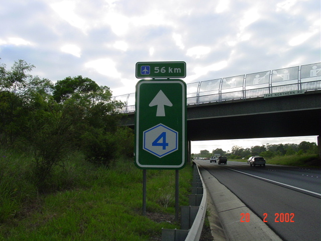
Metroad 4 trailblazer on the Western Motorway at The Northern Rd, Orchard Hills.
In 2013, RMS will be implementing a new alpha-numeric route numbering system. For more information, visit the RMS Website. |
|
Forthcoming alpha-numeric route number: |
|
Length: 64km
Eastern Terminus: Bradfield Hwy & Cahill Expressway, Millers Point
Western Terminus: Gt Western Hwy, Lapstone
Route taken: Western Distributor, The Crescent, City West Link, Dobroyd Pde, Wattle St, Parramatta Rd, Western Motorway
Focal points: Sydney, Parramatta, Penrith, Blue Mtns, Katoomba
RTA Internal Classification: Main Road 165 (Western Distributor), Main Road 650 (The Crescent/City West Link/Dobroyd Pde/Wattle St), State Highway 5 (Parramatta Rd), Main Road 6004 (Western Motorway)
Route overview:
Metroad 4 is the major western route in Sydney, fulfilling the role of the Great Western Hwy, which it parallels for its entire journey. It has a long section of motorway west of Concord and utilises the Western Distributor closer to the city but is let down by the congested section of Parramatta Rd it uses between Ashfield and Concord. Plans for a surface freeway between Concord and the City were cancelled in February 1977 but the need for a freeway here is being investigated as a tolled tunnel. More information is available on the M4 page.
Metroad 4 was the first Metroad route to be signposted in Sydney in September 1992, closely following the opening of the Mays Hill-Prospect section of the Western Freeway. This orginal routing used Parramatta Rd (Gt Western Hwy) between Concord and Broadway. In June 1993, the M4 was extended west to Lapstone and so was Metroad 4, now terminating midway through the climb to Glenbrook. In December 2000 the most significant change took place, switching Metroad 4 onto the newly constructed City West Link, meaning western suburbs traffic now entered the city via Anzac Bridge.
The initial plan for the Metroad system involved Metroad 4 extending east from Broadway along Cleveland St and City Rd to Metroad 1 (South Dowling St), consistent with the stategy of ending Metroads at other Metroads. Signage of this alignment went up (wb only) but most of it was removed in favour of "To Metroad 4" during the late-1990s. The eastbound signs always showed "To Metroad 1".
Notable events in the history of Metroad 4:
September 1992 - Metroad 4 replaces NR32 between Emu Plains and Broadway
June 1993 - Metroad 4 extended 2km west to Lapstone
December 2000 - Metroad 4 re-routed onto City West Link
Explore Metroad 4:
|
Photos of Metroad 4's western terminus: Great Western Hwy, Glenbrook |
|
 |
Westbound 'END Metroad 4' signage. May 2004. |
 |
Eastbound 'END NR32 START Metroad 4 1km' signage. May 2004. |
Last updated 12 December 2012 © Ozroads 2003-2012. |