CITY WEST LINK
(Including Wattle St, Dobroyd Pde & The Crescent)
Length: 5km
Eastern Terminus: Victoria Rd & The Crescent, Rozelle
Western Terminus: Parramatta Rd, Wattle St & Frederick St, Ashfield
Route Numbers: Metroad 4
RTA Internal Classification: Main Road 650
Opened to traffic:
Stage 1 (Underpass at Victoria Rd) - December 1991
Stage 2 (The Crescent to Catherine St) - February 1993
Stage 3 (Catherine St to Boomerang St) - June 2000
Route Overview:
The City West Link was constructed to link Parramatta Rd with the Anzac Bridge, providing better access to the CBD from the west. The current route is largely purpose built as a limited access road but sectiosn take advantage of former residential streets. Essentially the route traces its origins back to the 1960's, when the bridge over Hawthorne Canal opened in July 1965, linking Liyfield Rd and Dobroyd Pde, providing and alternative city access for Parramatta Rd traffic via the old Glebe Island Bridge. Following considerable traffic growth following the opening of the Western Freeway which fed more traffic into Parramatta Rd and then through Lilyfield, the problem of additional cappacity was magnified. Construction was commenced in 1988 on the new Glebe Island Bridge (now Anzac Bridge), which would increase the capacity of this entrance to the city. In conjunction with the new bridge, a controlled access road was to be constructed through Lilyfield to bypass the narrow and congested Lilyfield Rd. The first stage of this upgrade, a citybound underpass beneath Victoria Rd, opened to traffic in December 1991. The second stage followed two years later, in February 1993, from The Crescent at Rozelle to Catherine St at Lilyfield, utilising Brennan St. This section also employed an interim one-way street system to deliver traffic to Lilyfield Rd between Balmain Rd and Catherine St. In May 1995, reconstruction of Dobroyd Pde and Wattle St was completed, providing a four lanes between Parramatta Rd and Hawthorne Canal.
The final stage of the City West Link was opened to traffic in December 2000, extending the four lane limited access road from Catherine St to Dobroyd Pt, including a new bridge over the Hawthorne Canal. The City West Link subsequently recieved the Metroad 4 shield, relieving Parramatta Rd and relegating Lilyfield Rd back to a minor residential street.
Now, only 4 years after its completion, the City West Link is already needing to be bypassed. Plans for a M4 East tunnelled motorway will bypass Parramatta Rd between Concord and Ashfield, but will dump more traffic onto the City West Link. The link was built on the cheap and will become a huge bottleneck as the only traffic light between Artarmon and Glenbrook (via the Western Distributor and M4). My preference for the M4 East is to have the City West Link fully grade separated utilising the soon-to-be-closed White Bay goods line corridor. A portal for the tunnel could be constructed just east of Norton St, where the rail tunnel currently enters a tunnel.
Photos of Metroad 4 - City West Link |
|
 |
Looking east on Parramatta Rd approaching the turnoff to the City West Link (Wattle St), Ashfield. Photo taken June 2004. |
 |
Looking north on Frederick St approaching the start of the City West Link (Wattle St), Ashfield. Photo taken June 2004. |
 |
Approaching the end of Wattle St, where Metroad 4 rejoins Parramatta Rd. Photo taken June 2004. |
 |
Looking south west on Wattle St approaching Ramsay Rd, Haberfield. Note the four-lane undivided configuration. Photo taken June 2004. |
 |
Dobroyd Pde looking west along Iron Cove. Photo taken July 2004. |
 |
Looking east from the footbridge at Blackmore Park. Photo taken July 2004. |
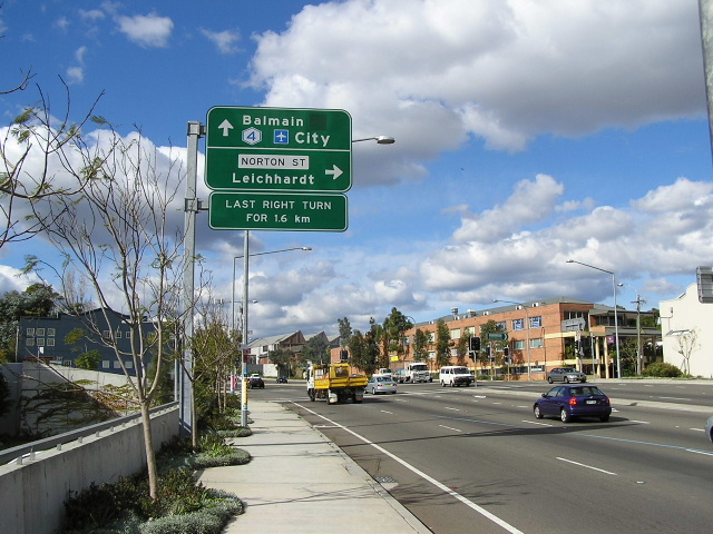 |
Looking east to Norton St, Lilyfield. Photo taken July 2004. |
 |
Looking west towards Balmain Rd. Photo taken July 2004. |
 |
Looking east to the end of the City West Link at The Crescent, Rozelle. Photo taken March 2004. |
 |
Aerial view over the first stage of the City West Link in 1993. |
 |
Looking east to Anzac Bridge along the City West Link in 1993. |
Back to Metroad 4
Back to M4 Motorway