NEWELL HIGHWAY
State Highway No. 17

Unusual AD sign near the Oxley Highway junction, 5km north of Coonabarabran. This sign was installed because previously the Gilgandra-Coonabarabran section of the Newell Highway was part of the Oxley Highway. Oct 2004.
Length: 1058km
Northern Terminus: Cunningham Hwy, Goondiwindi (QLD)
Southern Terminus: NSW/VIC Border, Tocumwal
Route Markers: National Highway 39
Focal Points: Melbourne, Tocumwal, Finley, Jerilderie, Narrandera, West Wyalong, Forbes, Parkes, Dubbo, Gilgandra, Coonabarabran, Narrabri, Moree, Goondiwindi
RTA Internal Classification: State Highway No. 17
Declared a State Highway: 1938
Named: July 1941
The Newell Highway is State Highway No. 17 and New South Wales ’ longest highway, stretching over 1,060km from the Victorian border at Tocumwal to the Queensland border at Goondiwindi. Traversing the state from end to end, the Newell Highway passes through almost every type of terrain imaginable, from an arm of the Warrumbungle Ranges to the flat and featureless plains near Narrandera. The Newell Highway carries the National Highway 39 shield for its entire length, forming the NSW portion of the now defunct Melbourne-Brisbane link of the National Highway.
Between 1965 and November 1992 the Newell Highway carried the National Route 39 shield (black & white) and many remnants still exist along the highway, particularly at Narrabri, Coonabarabran and Parkes. Large amounts of non-reflective signs also have reflective NH39 coverplates, a clear indication that they once showed NR39.
Open road sections of the Newell Highway are mostly 110km/h zones (NRMA quoted 70% of the highway in their 2002 audit) and it forms a boundary between the more densely populated eastern half of the state and the flat, sparse western plains.
Explore the Newell Highway:
The Man behind the Name: H.H. Newell (DMR Article)
National Route 39 Remnants (not included in photos below)
Notable events in the history of the Newell Hwy:
1889 - old timber bridge over Mehi River, Moree
1893 - old bridge over Lachlan River, Forbes
1895 - old bridge over Murray River, Tocumwal
1911 - old bridge over Narrabri Creek
1914 - old bridge over MacIntyre River, Goondiwindi
1918 - old bridge over Lake Forbes
1920 - old bridge over Murrumbidgee River, Narrandera
1935 - Bridge over Broadwater Creek, Moree
Mar 1938 - Proclaimed State Highway No. 17
Jul 1941 - Named 'Newell Highway'
26 Sep 1945 - Re-routed to eastern side of railway between Gillenbah and Morundah
Sep 1949 - Constructed to unsealed standard between Narrabri and Coonabarabran
18 Jan 1952 -
Permanent route gazetted between Narrandera and Wyalong
Apr 1960 - Bridge over Mehi River, Moree
Feb 1966 - Brocklehurst Deviation
Apr 1970 - Bridge over Lake Forbes
Dec 1973 - bituminous sealing completed
5 Dec 1975 - Highway extended from Boggabilla to MacIntyre River bridge at Goondiwindi
Sep 1977 - Bridge over Narrabri Creek, Narrabri
Feb 1982 - Bridges over Murrumbidgee River and floodplain, Narrandera
May 1984 - Mulgate Deviation (north of Narrabri)
9 Sep 1987 - Jack Renshaw Bridge over Castlereagh River, Gilgandra
Dec 1987 - Tocumwal Deviation and bridge over Murray River
Jul 1988 - Narrandera railway overpass
Feb 1991 - Reconstruction 2-13km south of Coonabarabran
Oct 1992 - Goondiwindi Bypass
Dec 1992 - West Narrabri Deviation
15 Jan 1993 - Newell Hwy redeclared to eliminate breaks and become one continuous route from Tocumwal to Goondiwindi
Jan 1993 - Dubbo Relief Route & bridge over Macquarie River
Feb 1995 - Mid Western Hwy junction at Marsden reconstructed
Mar 1995 - Fitzgeralds Bridge over Lachlan River, Forbes
22 Dec 1996 - Mary Jane Cain Bridge over Castlereagh River, Coonabarabran
1998 - Realignment at Forbes
Aug 2001 - Realignment in Parkes
Feb 2006 - Ardlethan Realignment
 |
Looking south across the MacIntyre River into New South Wales on the Newell Highway. Jan 2005. |
 |
The last NSW directional sign before the Newell Hwy ends at the Queensland Border. Jan 2005. |
 |
ID signage at the Newell Hwy/Bruxner Hwy junction in Boggabilla. Jan 2005. |
 |
Southbound approaching the Carnarvon Highway in Moree. Oct 2004. |
 |
Poor signage on the Carnarvon Hwy approaching the Newell Hwy in Moree. Oct 2004. |
 |
Looking north at the narrow Mahaffey Bridge over Broadwater Creek, constructed in the late 1920s. April 2006. |
 |
Heavy traffic in both directions, looking south along Balo St (Newell Hwy), north of Heber St (Gwydir Hwy) in Moree. This type of congestion is the very reason the Moree Town Centre Bypass has been approved for construction. April 2006. |
 |
Heavy southbound traffic on Balo St (Newell Hwy) approaching Heber St (Gwydir Hwy) in Moree. This type of congestion is the very reason the Moree Town Centre Bypass has been approved for construction. April 2006. |
 |
Signage for the Newell Hwy on Gwydir Hwy eastbound in Moree. April 2006. |
 |
Looking south through Moree town centre. Oct 2004. |
 |
Signage for the Gwydir Hwy (eastbound) turnoff. Oct 2004. |
 |
Signage on the Gwydir Hwy westbound for the Newell Hwy in Moree. April 2006. |
 |
Large grain silos on the southern outskirts of Moree. Oct 2004. |
 |
Very unusual signage on the Newell Hwy 7km south of Moree. Paul Rands has kindly informed that "SR/108" means "Stock Route No. 108". Oct 2004. |
 |
Fingerboard signage at a turnoff for Terry-Hie-Hie in Bellata. Oct 2004. |
 |
Looking south through the tiny town of Bellata, between Moree and Narrabri. Oct 2004. |
 |
Looking north towards the grain town of Bellata. Oct 2004. |
 |
Southbound approaching the Bingara turnoff, on the northern outskirts of Narrabri. Oct 2004. |
 |
Southbound approaching the Kamilaroi Highway junction. Note the lack of a NR37 shield straight. Oct 2004. |
 |
Signage on Kamilaroi Hwy approaching the Newell Hwy. Note again no NR37 shield. Oct 2004. |
 |
Distance sign heading north on Tibbereena St (Newell hwy) in Narrabri. Oct 2004. |
 |
Bridge replacement works underway at Eathers Creek and Lagoon Creek in Narrabri. Oct 2004. |
Bridge over Narrabri Creek, December 1977. (DMR) |
|
 |
Northbound approaching the southern Kamilaroi Hwy junction at Narrabri West. Note the lack of a NR37 shield straight. Oct 2004. |
 |
Looking southwest from the Kamilaroi Hwy at Narrabri West. There is no distance sign leaving Narrabri. Oct 2004. |
Looking south over Bohena Creek following construction of a new bridge in 1977. (DMR) |
|
 |
The Newell Highway looking south between Narrabri and Coonabarabran before reconstruction in the early 1970s. (DMR) |
 |
Fingerboard signage in the Pilliga Scrub between Coonabarabran and Narrbri. Oct 2004. |
 |
Looking south nearing the Oxley Highway. Oct 2004. |
 |
Southbound AD sign for the Oxley Highway junction. Note the lack of a NR34 shield. Oct 2004. |
 |
Distance sign heading north from the Oxley Hwy. Jan 2003. |
 |
Signage on Oxley Hwy westbound approaching the Newell Hwy. Note the lack of a NR34 shield. Jan 2003. |
 |
Extremely large ID sign pointing Newell Hwy traffic north at the Oxley Hwy junction. Jan 2003. |
 |
Distance sign heading southwest from the Oxley Hwy junction. Note the lack of a NR34 shield again. Oct 2004. |
 |
Southbound AD sign for the Tourist Drive 1 on Chappell Ave, Coonabarabran. Oct 2004. |
 |
Looking south across the rail line and the Castlereagh River in Coonabarabran. Oct 2004. |
 |
Looking north along John St in Coonabarabran. Oct 2004. |
 |
Signage at the Binnaway turnoff, south of Coonabarabran. Note the incorrect highway name and missing NR34 shield. Oct 2004. |
 |
Distance sign heading north from the Mendooran turnoff. Note the incorrect SR34 shield. Oct 2004. |
 |
Correct distance sign southbound from the Mendooran turnoff. Oct 2004. |
 |
Looking south between Warkton and Gowang. Oct 2004. |
 |
Distance sign heading north from Tooraweenah. Oct 2004. |
 |
Distance sign heading south from Tooraweenah. Oct 2004. |
 |
Fingerboard signage just north of Gilgandra. Oct 2004. |
 |
Distance sign heading north from the Castlereagh Highway junction at Gilgandra. Oct 2004. |
 |
Southbound AD sign for the Castlereagh Hwy. Oct 2004. |
 |
Very poorly designed AD sign on Castlereagh Hwy approaching Newell Hwy. Oct 2004. |
 |
AD sign for Newell Highway on Oxley Hwy at Gilgandra. Note the green reflectorised coverplates on a black non-reflective sign. Jan 2003. |
 |
Northbound AD sign for the Oxley Hwy junction in Gilgandra. Oct 2004. |
 |
Distance sign heading south from Gilgandra. Oct 2004. |
 |
Distance sign heading north from Eumungerie. Jan 2003. |
 |
The bridge over the Talbragar River on the Brocklehurst Deviation in 1966. (DMR). |
 |
Unusual style sign on the northern approach to Dubbo, used when motorists are required to negotiate a fairly complicated urban area. Oct 2004. |
 |
AD sign on Golden Hwy approaching Newell Hwy in Dubbo. Oct 2004. |
 |
ID signage at the Newell Hwy/Golden Hwy junction in Dubbo. Oct 2004. |
 |
Diagrammatic signage for the Darling Street & Golden Hwy junctions in Dubbo. Note the NR32 shield is incorrect - Darling St is not NR32. Oct 2004. |
 |
Black AD sign with reflectorised NH39 coverplate on Darling St (old Newell Highway) approaching Erskine St (Newell Hwy). Oct 2004. |
 |
The use of the flash in this photo really emphasises the reflectorised parts of these signs - the border and legend of the black sign and the coverplate. Oct 2004. |
 |
Distance sign southbound on Darling St (old Newell Highway) near Talbragar St. Prior to 1993, the Newell Hwy passed through the centre of Dubbo on Darling St to the Mitchell Hwy. NR39 thence crossed the Macquarie River on the Mitchell Hwy, rejoining the existing highway (Whylandra St) at West Dubbo. Oct 2004. |
 |
Darling Street (old Newell Highway) looking south to the Mitchell Highway. Oct 2004. |
 |
Looking south beneath the railway overpass on the Dubbo Relief Route, Whylandra Street, opened in 1993. Oct 2004. |
 |
Very very old (possibly dating from 1965, when NR39 was first signed) ID sign at the Mitchell Hwy/Newell Hwy junction at West Dubbo. Oct 2004. |
 |
The other side of the above sign assembly, this time not so faded. Oct 2004. |
 |
AD sign on Mitchell Hwy westbound for the Newell Highway. The SR84 shield is a bit premature as the Golden Hwy does not begin for another 1.5km. Oct 2004. |
 |
Rarther unusual sign assembly facing Mitchell Hwy eastbound traffic. Oct 2004. |
 |
Fingerboard signage at the Obley Road junction on the southern outskirts of Dubbo. Unusual choice of Tomingly as a focal point. Oct 2004. |
 |
Distance sign heading north from Tomingley. Oct 2004. |
 |
Distance sign heading south from Tomingley. Oct 2004. |
 |
Distance sign heading north from Peak Hill. Oct 2004. |
 |
Looking south through Peak Hill. Oct 2004. |
 |
Rare NH39 trailblazer heading north near the radio telescope turnoff. Oct 2004. |
 |
Rare NH39 trailblazer heading south near the radio telescope turnoff. Oct 2004. |
 |
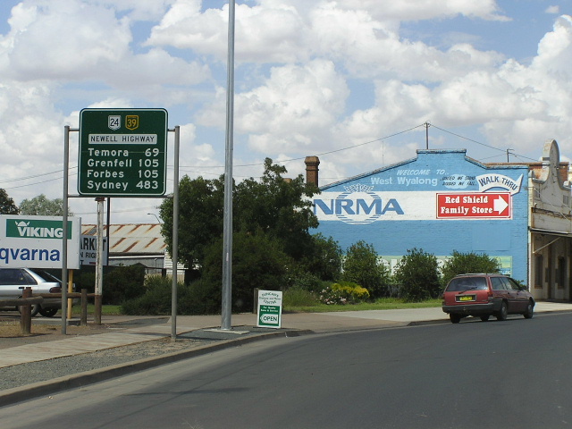
Looking south north of Parkes. Oct 2004. |
 |
Distance sign heading north from Parkes. Oct 2004. |
 |
New AD signage pointing southbound traffic onto the new alignment of Newell Highway through Parkes - Victoria St & Bogan St. Oct 2004. |
 |
Old non-reflective signage at the intersection of Clarinda St & Victoria St. The "Alternative Route for Heavy Vehicles" sign is an old one which refers to the current highway alignment via Victoria & Bogan Streets. This is the way it used to be signed. Oct 2004. |
 |
Remnant NH39 signage southbound on Clarinda St (old Newell Highway) approaching Welcome St & Dalton St in Parkes. Note the lack of a SR90 shield. Oct 2004. |
 |
More remnant NH39 signage - this one so old it has NR39 under the coverplate and no SR90 shield (possibly from 1965) - at the intersection of Clarinda St & Welcome St & Dalton St, Parkes. Oct 2004. |
 |
Rather poorly designed signage at the same intersection - perhaps a council installation? Oct 2004. |
 |
A view of Clarinda St which was, until August 2001, the Newell Higwhay. Oct 2004. |
 |
Looking south along Welcome St (Old Newell Highway). Oct 2004. |
 |
Another great old sign pointing Welcome St traffic onto Hartigan Ave (both part of the old Newell Higwhay). Oct 2004. |
 |
More old signage, this time pointing Newell Hwy traffic from Bogan St into Hartigan Ave. Oct 2004. |
 |
More old signage, this time at the intersection of Forbes St & Hartigan Ave. Oct 2004. |
 |
Distance sign heading south from Parkes. Oct 2004. |
 |
Quite feral looking distance sign heading north from the Mid Western Highway junction at Marsden. Feb 2006. |
 |
Northbound AD sign for the Mid Western Highway junction at Marsden. Note the incorrect SR24 shield - should be a NR24 shield. This junction was reconstructed in 1995 to reflect Newell Hwy traffic being the dominant flow but unfortunately there are no remnants of the former T-junction. Feb 2006. |
 |
Another feral-looking distance sign, this time heading west from Marsden. Note the incorrect SR24 shield which is larger than the NH39 shield. Feb 2006. |
 |
Being, until January 1993, part of the Mid Western Highway, the Marsden-West Wyalong section of Newell Highway not only has kilometre plates for Forbes (Newell Hwy focal point) but for Grenfel as well (Mid Western Hwy focal point). Here is an example of one, midway between Wyalong and Marsden. Feb 2006. |
 |
Remnant 1980s Mid Western Highway name plate on a fingerboard sign at the Quandialla turnoff, just east of Wyalong. Feb 2006. |
 |
Northbound AD sign on State Route 85, approaching Newell Highway at Wyalong. Note the lack of a NH39 shield left. Feb 2006. |
 |
AD sign eastbound on Newell Hwy approaching the beginning of SR85 at Wyalong. Feb 2006. |
 |
Distance sign heading west into Wyalong from State Route 85. Feb 2006. |
 |
Looking east through the tiny town of Wyalong. Feb 2006. |
 |
Unusual hand-painted distance sign, heading east from West Wyalong. Feb 2006. |
 |
Looking west through the main street of West Wyalong. Feb 2006. |
 |
Looking east into West Wyalong town centre. Feb 2006. |
 |
Diagrammatic AD sign heading west on Newell Hwy approaching the junction with Mid Western Hwy at West Wyalong. Feb 2006. |
 |
Distance sign heading east from the Mid Western Hwy junction into West Wyalong. Feb 2006. |
 |
Mid Western Highway eastbound approaching Newell Hwy at West Wyalong. Feb 2006. |
 |
Northbound Newell Highway approaching Mid Western Hwy at West Wyalong. Feb 2006. |
 |
Black painted ID sign with NH39 on a coverplate over NR39 - at the junction with Town By-pass Road. Feb 2006. |
 |
Diagrammatic AD sign southbound approaching Tallimba Rd. This one of several major turns that Newell Hwy traffic must make to remain on the highway in south western NSW. Feb 2006. |
 |
Distance sign heading south from Tallimba Rd towards Ardlethan. Feb 2006. |
 |
Distance sign heading north from Burley Griffin Way, near Mirrool. Feb 2006. |
 |
Southbound AD sign approaching the junction with Burley Griffin Way near Mirrool. Feb 2006. |
 |
Distance sign on NH39/SR94 duplex, heading east from the junction with Burley Griffin Way near Mirrool. Feb 2006. |
 |
Clear and concise diagrammatic AD sign heading east on Newell Hwy approaching the junction with Burley Griffin Way near Mirrool. This is another of the major turns that Newell Hwy traffic must make to remain on the highway in south western NSW. Feb 2006. |
 |
Looking west along the NH39/SR94 duplex. Feb 2006. |
 |
Services sign typical in western NSW, informing motorists that a town with services is approaching. Feb 2006. |
 |
National Highway project sign for the Ardlethan Realignment. If you take a look at the diagram, you can see that the Newell Highway has already once been realigned at this location - way back in 1970. The newer deviation was opened to traffic in February 2006 and eliminated one of the several T-junctions along the Newell Hwy in southwestern NSW. Feb 2006. |
 |
Roadwork underway on the Ardlethan Realignment with a tourist AD sign for the Burley Griffin Way turnoff. Feb 2006. |
 |
New AD sign for the new Burkey Griffin Way junction which was not yet opened to the public. Feb 2006. |
 |
New distance sign heading east from the Burley Grffin Way junction. Note the lack of focal points (where is the mention of Brisbane?) and no SR94 shield! Feb 2006. |
 |
A pre-opening view of the realignment and new bridge over Mirrool Creek. Feb 2006. |
 |
Diagrammatic AD sign approaching the old junction with Burkey Griffin Way at Ardlethan. Feb 2006. |
 |
Southbound on the old alignment of Burley Griffin Way approaching the old junction with Newell Highway at Ardlethan. Feb 2006. |
 |
Northbound on the old alignment of Newell Hwy approaching the old junction with Burley Griffin Way. Feb 2006. |
 |
A view of the new high-level deviation and the old flood-prone highway side-by-side, just south of Ardlethan. Feb 2006. |
 |
Distance sign heading south from Ardlethan on the new highway alignment. Note the lack of a mention of Melbourne and the dodgy spacing of the numbers. Feb 2006. |
 |
Distance sign heading north from Narrandera. Jan 2004. |
 |
ID sign assembly at the intersection of Whitton St & Cadell St in Narrandera. Not sure why NH20 gets a mention here or why a NH39 shield is included as it does not go anywhere near either of those focal points. Jan 2004. |
 |
Northbound AD sign for Irrigation Way (Audley St) in Narrandera. Jan 2004. |
 |
Approaching the Newell Highway from Sturt Highway westbound at Gillenbah. Jan 2004. |
 |
Rare dual-highway name signage at the eastern junction with Sturt Hwy at Gillenbah. Until January 1993, this 500m section of road was classified as part of State Highway No. 14 (Sturt Hwy) but is now part of State Highway No. 17 (Newell Hwy). Sensibly, this sign shows both highway names so that travellers looking for the Sturt Hwy don't get confused when they see only the Newell Hwy name. Jan 2004. |
 |
AD sign westbound on Newell Hwy approaching the western junction with Sturt Hwy at Gillenbah. Jan 2004. |
 |
AD sign eastbound on Sturt Hwy approaching the junction with Newell Hwy at Gillenbah. Jan 2004. |
 |
ID sign assembly at the western junction of Newell and Sturt Highways, Gillenbah. Jan 2004. |
 |
Distance sign heading south from the Sturt Highway at Gillenbah. Jan 2004. |
 |
Distance sign heading north from the Kidman Way. Note the incorrect NR39 shield. Jan 2005. |
 |
Southbound AD sign for the Kidman Way junction. Again note the incorrect NR39 shield. Jan 2005. |
 |
Signage on the Kidman Way southbound for the Newell Highway. Jan 2005. |
 |
Northbound AD sign for Kidman Way. Jan 2005. |
 |
Distance sign heading south from the Kidman Way junction. Jan 2005. |
 |
Unusual AD sign showing different options for interstate travellers. Note the SR52 shield - should be a SR87 shield. Jan 2005. |
 |
Distance sign heading north from Jerilderie. Jan 2005. |
 |
Interesting sign heading north from Jerilderie, showing a NH39 shield on a services sign. Jan 2005. |
 |
Looking west along the main street of Jerilderie. Jan 2005. |
 |
Distance sign heading south from Jerilderie. Jan 2005. |
 |
Riverina Hwy eastbound approaching the Newell Hwy in Finley. Jan 2005. |
 |
ID sign at the Riverina Hwy junction in Finley. Jan 2005. |
 |
Distance sign heading south from Finley. Jan 2005. |
 |
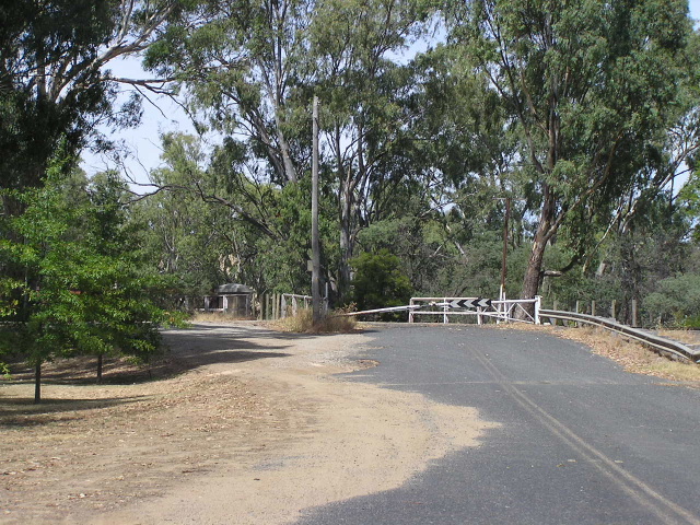
National Highway diagrammatic sign southbound on the very uninteresting 20km stretch between Finley and Tocumwal. Feb 2006. |
 |
Distance sign heading north from Tocumwal. Feb 2006. |
 |
Unusual style of double-chevron ID sign on the northern outskirts of Tocumwal. Feb 2006. |
 |
Looking south into Tocumwal along the old alignment of Newell Highway (Murray Street). Feb 2006. |
 |
Not a remnant sign but probably a direct copy of an old sign at the intersection of Murray St & Deniliquin Rd in Tocumwal. Feb 2006. |
 |
Looking south along Murray St into Tocumwal town centre. Feb 2006. |
 |
Remnant "Melbourne" painted black ID sign at the same intersection (former alignment of Newell Hwy). Feb 2006. |
 |
Looking south along Bridge Street apporoaching the old rail/road shared bridge over the Murray River. The Newell Highway shared this bridge with interstate rail traffic until the current 2-lane concrete bridge was built in 1987. Feb 2006. |
 |
A closer view of the northern approach to the bridge, showing the gate which would block road traffic from using the bridge while trains were going past and vice versa. Feb 2006. |
 |
A side-view of the single-lane opening bridge over the Murray River which carried Newell Highway traffic from 1938 until 1987. Feb 2006. |
 |
Signage on the Tocumwal-Mathoura Rd approaching the Newell Hwy at Tocumwal. Feb 2006. |
 |
Distance sign heading south from Tocumwal, moments before southbound traffic crosses the Murray River into Victoria. Feb 2006. |
 |
A side view of the Edward Hillson Bridge which carries Newell Highway traffic over the Murray River. Feb 2006. |
 |
The beginning of the Newell Hwy, looking north from the Goulburn Valley Hwy in Victoria across the river into NSW. Jan 2004. |