KINGS CROSS TUNNEL
Sydney's first road tunnel
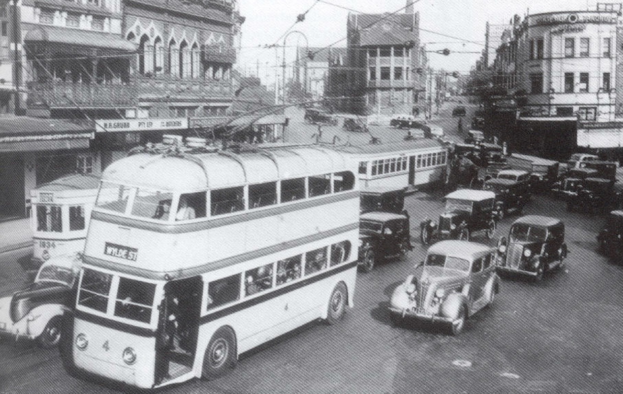
Kings Cross in 1938.
Length: 500m (approximately)
Eastern Portal: Ward Ave (formerly Kellet St), Darlinghurst
Western portal: Victoria St, Darlinghurst
Route Markers: Formerly SR76 (1976-2004)
Opened to traffic: 15th December 1975
The Kings Cross Tunnel is made up of twin 3-lane tubes beneath the locality in inner eastern Sydney known as Kings Cross. It was constructed by the cut and cover method and the airspace above the tunnel later sold for development. The tunnel was coordinated with the construction of the Eastern Suburbs Railway as they are in close proximity to each other.
The purpose of the tunnel is to provide a route for through traffic between William St and New South Head Rd, significantly reducing the conflict between through traffic, local traffic and cross traffic in the Kings Cross precinct. The importance of the tunnel itself has been reduced following the construction of the Cross City Tunnel (opened in June 2005) which bypasses the Sydney CBD altogether.
The proposal for a road tunnel under Kings Cross was publicly announced on the 17th of February 1969, by the Minister for Highways, after several years of investigation by the Department of Main Roads regarding the feasibility of construction and the respective virtues of shorter and longer tunnels. The option for a short, shallow tunnel was chosen, to be constructed by the cut and cover method. This option was most favourable from an engineering perspective and minimised interference with the Eastern Suburbs Railway Tunnel.
The Department of Main Roads provided this description of the proposed tunnel project in the September 1972 edition of ‘Main Roads’:
“In the tunnel, dual carriageways will each carry two lanes of traffic. Eastbound traffic will leave William St near Dowling St and enter the tunnel at Darlinghurst Rd. After leaving the tunnel near Craigend Place this traffic will join Bayswater Rd near Roslyn St. Westbound traffic will leave New South Head Rd near New Beach Rd, and continue along a new road to be built under the Eastern Suburbs Railway Viaduct at Rushcutters Bay. This traffic will enter the tunnel at Craigend Place and, on leaving it, will join William St, near Dowling St. In the tunnel, a continuous breakdown lane will be provided beside each carriageway.” (p. 19)
Before construction could commence, 118 properties had to be resumed by compulsory acquisition and compensation was paid to owners and tenants. Construction itself was undertaken in several stages to minimise interruptions to vehicular and pedestrian movements while allowing the relocation of a complex network of utilities. The first stage, commenced in 1971, involved the construction a bridge at Craigend Place, which will form the eastern portal of the tunnel, followed by a bridge at Victoria St, which will form the western portal.
Construction of the tunnel proper began in June 1973 with a 700 foot (approximately 225m) long cutting. Structurally it consists of two outside walls and one central wall between the two carriageways, with the ceiling suspended from pre-stressed concrete roof beams. The DMR also states that the proposed development above the tunnel will be supported on footings and columns located in the central wall and beyond the outer walls.
In conjunction with the plan for the Kings Cross Tunnel, the City of Sydney adopted a series of proposals in December 1969 which provided for the development of William St as a beautiful tree-lined boulevard with wide pedestrian walkways (similar to the current proposals in conjunction with the Cross City Tunnel). After conferences with the DMR, the City of Sydney decided to further widen William St to provide four lanes of traffic in each direction with a 16 feet wide median strip (to include turning bays). The plan involved widening the sunny southern side of William Street and using a 27-feet wide residue of land to create a tree-lined pedestrian mall between Yurong St and Kings Cross. Unfortunately this proposal never eventuated and similar plans, this time involving the narrowing of the road carriageway, have been included in the Cross City Tunnel project.
The Kings Cross Road Tunnel was opened to traffic on Monday the 15th of December, 1975 and completed at a cost of $21.3 million (1975), including $13.1 million (1975) for property acquisition.
Since opening, the westbound tube has been restriped to provide three traffic lanes, the right-most lane acting as a right-turn lane into Palmer St, feeding traffic onto Metroad 1 northbound. Major changes will sound in June 2005 when the Cross City Tunnel opens to traffic. Construction has been progressing on this project for nearly 3 years and it shall bypass the Kings Cross Tunnel and the Sydney CBD - therefore theoretically taking a large chunk of traffic out of the tunnel. The eastern portals of the CCT also happen to be located next to the eastern portals of the Kings Cross Tunnel, making for some interesting approaches and signage!
Photos of the Kings Cross Tunnel |
|
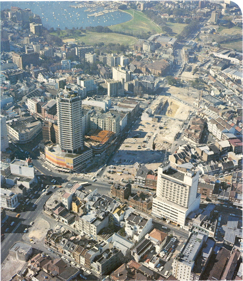 |
Aerial view of early construction - looking east - in 1971. See the whole two blocks of high-density development that was levelled to make way for this project. |
 |
This time looking west over the construction site in 1973. You can see the bridges which form the portals are nearly completed. |
 |
Again looking west - this time in 1974 - showing the tunnel itself completed and the roof being installed. |
 |
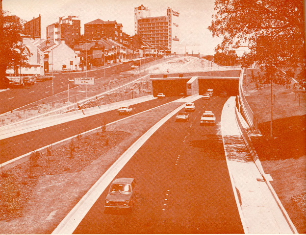
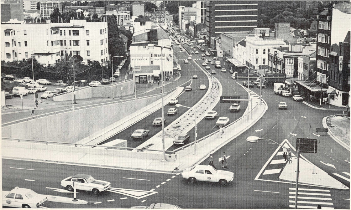
Following opening now. This is looking east to the Victoria St (western) portal in December 1975. |
 |
This pic is looking east from the Ward Ave (eastern) portal. That weird looking thing popping out of the ground in the middle ground is the Eastern Suburbs Railway. Dec 1975. |
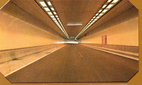 |
An insideers view of travelling through the westbound tunnel. The lanes have since been narrowed to provide for 3 traffic lanes with no shoulder. Dec 1975. |
 |
A rather orange view of the eastern portal looking west. Dec 1975. |
 |
Looking west along William St from Kings Cross towards the CBD. You can see the lane that runs behind a row of buildings on the left (south) side of William St. This row of buildings was to be demolished to make way for a widened William St but it never eventuated. Dec 1975. |
Looking east from the Ward Ave bridge (eastern portal). The distance sign - missing, but prepared for, a SR76 shield reads "Edgecliff 1; Double Bay 2; Rose Bay 5; Vaucluse 7". Dec 1975. |
|
A look at the roof of the tunnel prior to development of the airspace above it. The concrete blocks sticking out are the tops of the columns that will make up the footings of future buildings. Dec 1975. |
|
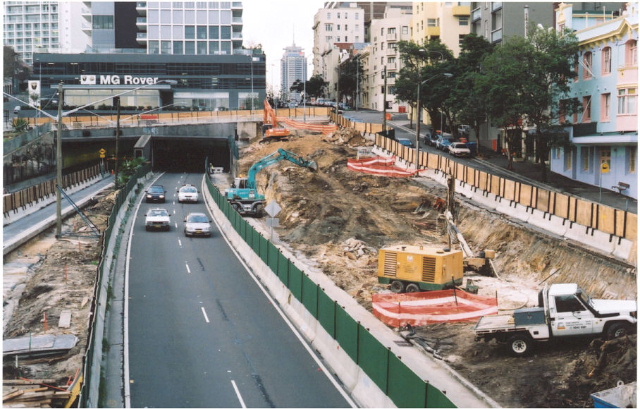 |
Looking west into the eastern portal showing early Cross City Tunnel construction works. July 2003. |
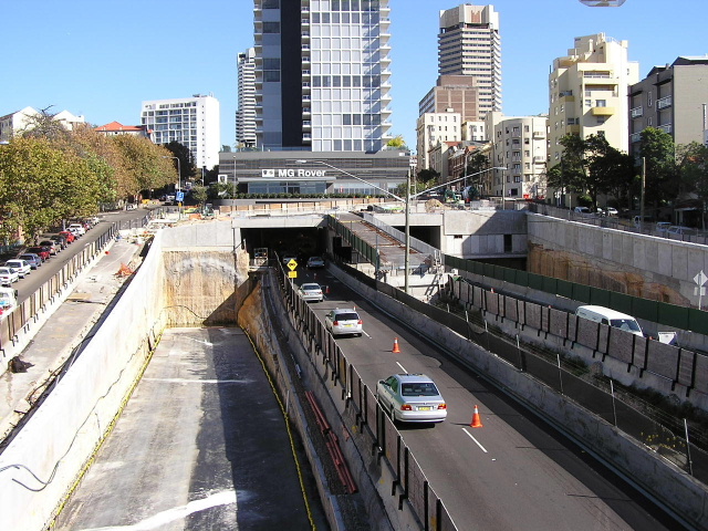 |
Looking west into the eastern portal showing much progressed CCT work. April 2004. |