ALPHA-NUMERIC ROUTE NUMBERING FOR NSW
It is here!
This page was created to showcase the evidence of future alpha-numeric route marking within NSW. There have been an increasing amount of sightings of alpha-numeric signage appearing predominately rural areas, although it is quite obvious that new signs being installed across that state have alpha-numeric route markers beneath coverplates showing the current route marker. This process of installing the sign and coverplate was recently witnessed at the Philip Parkway in western Sydney.
Below is a gallery of alpha-numeric signage i have been able to photograph and there may be more out there waiting to be spotted. I have not included the numerous coverplated signs that exist all over Sydney and Newcastle due to space and time constraints. If anyone spots new alpha-numeric signage and would like to contribute a photo for this site, please feel free to contact me! All photos below were taken by webmaster unless otherwise noted.
Update: Westlink M7 opened to traffic on 16 December 2005 with alpha-numeric route marker signs. This suggests we may see a gradual rolling out of the alpha-numeric system beginning very soon!
Update: Personal correspondance with the RTA has indicated that alpha-numeric route marking has arrived in NSW. However, there is not currently funding to implement the entire system so M7 will remain the only officially sanctioned route for the foreseeable future.
September 2006: Route D5 has been introduced to direct traffic between the M5 (West) and the Airport Tunnel when the M5 East tunnel is closed.
January 2008: I have discovered that coverplated alpha-numeric signs at the intersection of Donald St, Selma St & Gordon Ave, Newcastle West, were installed in February 2001. This appears to be the earliest alpha-numeric installation in New South Wales.
June 2008: Tugun Bypass opened to traffic and signed as M1, including the section within NSW. RTA has confirmed that a section of M1 has officially been commissioned in NSW, running from the junction with Gold Coast Highway to the QLD Border.
March 2011: Gallery split into two parts to reduce loading times and make it easier to view new images.
Photos of alpha-numeric route markers in NSW, 2004-2009
 |
"A32" signage on the Gt Western Hwy at Shell Corner. May 2004. |
 |
"A32" signage on the Gt Western Hwy at Shell Corner. May 2004. |
 |
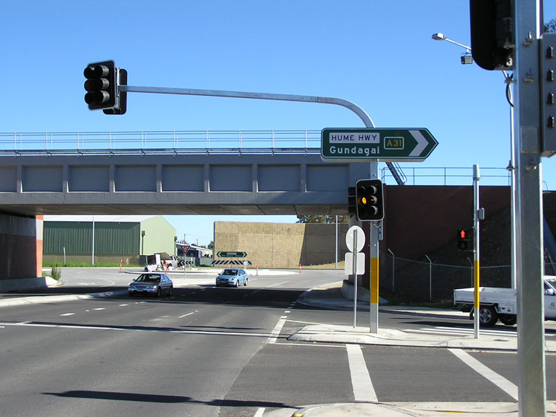
"A31" signage on the Hume Hwy at Marula. July 2004. |
 |
"A31" signage on the Hume Hwy at Marulan. July 2004. |
 |
"B75" AD sign on the Cobb Hwy in Deniliquin. Jan 2005. |
 |
"B75" distance sign northbound on the Cobb Highway in Deniliquin. Jan 2005. |
 |
"B58" distance sign on the Riverina Hwy heading east from Deniliquin. Jan 2005. |
 |
Fingerboard sign on the Riverina Highway near Blighty. Jan 2005. |
 |
"B79" sign on the Silver City Highway at South Broken Hill. Jan 2005. |
 |
More A31 signage on the Hume, this time near Jerrawa Rd between Gunning and Yass. Jan 2005. |
 |
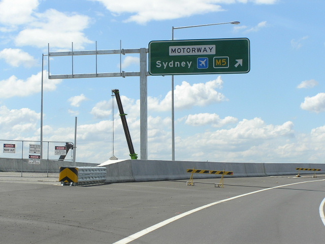
Covered "M7" sign southbound on the Philip Parkway, which will become the Westlink M7. Feb 2005. |
 |
New sign on the northbound on-ramp to the M5 Motorway at Camden Valley Way. Feb 2005. |
 |
Ben Johnson took this pic of sign crews installing a new sign (albeit in the wrong place) out at Eastern Creek. The correct sign was eventually installed and then coverplated on Wallgrove Rd. Feb 2005. |
 |
These signs are at the exit from Rhodes Waterside Shoppping Centre. It is interesting to note that the "A3" has been covered but not the "M2" or "M4". Mar 2005. |
 |
On the yet-to-be-opened ramp from the M7 to Old Windsor Rd/Norwest Blvd at Glenwood. April 2005. |
 |
D5 sign on Stoney Creek Rd at Bexley. The common opinion is that the D stands for Detour - suggesting that this is a signposted detour route for the M5 East Tunnel. April 2005. |
 |
M7 sign on the corner of Wallgrove Rd and Saxony Rd, Horsley Park. Ben Johnson took this pic in April 2005. |
 |
A39 sign on the Newell Highway at Grong Grong. Photo by Rob Tilley in April 2005. |
 |
M1 signage for the Cross City Tunnel, due to open in July 2005, northbound on Harbour St at Darling Harbour. May 2005. |
 |
More alpha-numeric signage associated with the Cross City Tunnel, this time eastbound on the Bathurst St viaduct. June 2005. |
 |
Another alpha-numeric sign associated with the Cross City Tunnel, this time westbound on Craigend St, Darlinghurst. June 2005. |
 |
The full version of the above sign, taken the next day. June 2005. |
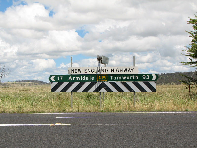
Newly erected A15 signage (without the National Highway shield) on the New England Highway at Armidale. Thanks to Paul Rands for this pic. June 2005. |
|
Pacific Highway southbound at Croki Road, between Taree and Coopernook showing A1. Photo by Stephen Mok in July 2005. |
|
M7 signage for the (yes, you guessed it) Westlink M7 on the Philip Parkway Extension at Rooty Hill. Aug 2005. |
|
 |
More gantry signage for the Cross City Tunnel, this time including a complementary A4 shield - westbound on Craigend St at Rushcutters Bay. Aug 2005. |
 |
"B63" signage on Nelson Bay Rd (SR121) at Fullerton Cove near Newcastle. This sign is one of four alpha-numeric signs installed at this upgraded intersection. Sep 2005. |
 |
More B63 signage at the same intersection. Sep 2005. |
 |
Yet another B63 sign at the same intersection. Sep 2005. |
 |
Ditto. Sep 2005. |
M7 distance sign on the yet-to-be-opened Westlink M7 near Chandos Rd, Horsley Park. Sep 2005. |
|
 |
M7 freeway AD sign southbound on the Westlink M7 near Chandos Rd, Horsley Park. Sep 2005. |
 |
M7 shield on a new ID sign at the intersection of Wallgrove Rd & Saxony Rd, Horsley Park. Sep 2005. |
Masking tape covers this M7 shield on Elizabeth Dr at Wallgrove Rd, Cecil Park. Sep 2005. |
|
Partially uncovered AD sign showing "A40" shield on Old Windsor Rd southbound approaching the M7. Sep 2005. |
|
 |
2km AD sign for the Richmond Rd interchange on the Westlink M7. Oct 2005. |
M7 AD sign for the M4 Motorway at Eastern Creek. Oct 2005. |
|
 |
B55 signage on the Castlereagh Highway heading north at the Lightning Ridge turnoff. Photo by Paul Rands in November 2005. |
 |
B55 and incorrect State Route 55 signs on Castlereagh Hwy at the Lightning Ridge turnoff. Photo by Paul Rands in November 2005. |
 |
B55 signage for the Castlereagh Hwy at the Lightning Ridge turnoff. Photo by Paul Rands in November 2005. |
 |
B55 sign on the Castlereagh Highway heading north from Lightning Ridge. Photo by Paul Rands in November 2005. |
 |
M1 sign on Southern Cross Dr northbound approaching the beginning of the Eastern Distributor at Rosebery. Photo by Winston Yang in November 2005. |
 |
M4 AD sign southbound on Mamre Rd at St Marys. Dec 2005. |
 |
A32 signage on Great Western Hwy in Bathurst. Jan 2006. |
 |
More A32 signage on Great Western Hwy in Bathurst. Jan 2006. |
 |
And again. Jan 2006. |
 |
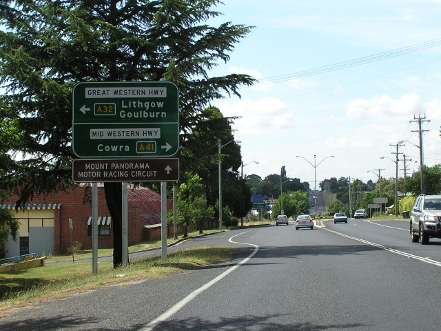
A41 and A32 signage on Gt Western Hwy approaching Mitchell & Mid Western Hwys in Bathurst. Jan 2006. |
 |
New A32 distance sign on the Mitchell Hwy heading west from the junction with Gt Western and Mid Western Highways at Bathurst. Jan 2006. |
 |
A41 and A32 advance direction sign eastbound on Mitchell Hwy approaching the Gt Western and Mid Western Highways at Bathurst. Jan 2006. |
 |
A32 intersection directional sign at the Gt Western/Mid Western/Mitchell Hwy junction in Bathust. Jan 2006. |
 |
A41 sign at the same junction in Bathurst. Jan 2006. |
 |
A41 distance sign heading southwest from Bathurst on the Mid Western Hwy. I believe a big mistake has been made here - assuming the A41 turns south onto the current NR41 - Olympic Hwy at Cowra, only the first two focal points will even be on route A41! Jan 2006. |
 |
A41 fingerboard sign on Mid Western Hwy at Browning Street, Bathurst. Jan 2006. |
 |
A41 fingerboard sign on Mid Western Hwy at Browning Street, Bathurst. Jan 2006. |
 |
A32 advance direction sign on the Mid Western Hwy approaching the Mitchell and Gt Western Highways in Bathurst. Jan 2006. |
 |
A32 ID sign pointing onto the Mitchell Hwy from Mid Western Hwy in Bathurst. Jan 2006. |
 |
A32 sign pointing down Gt Western Hwy from Mid Western Hwy & Mitchell Hwy in Bathurst. Jan 2006. |
 |
A32 & A41 stack AD sign on Brilliant St approaching the Gt Western, Mid Western and Mitchell Highways in Bathurst. Jan 2006. |
 |
A41 ID sign pointing down the Mid Western Hwy from Brilliant St, Bathurst. Jan 2006. |
 |
A32 sign pointing down the Mitchell Hwy from Brilliant St, Mid Western Hwy & Gt Western Hwy, Bathurst. Jan 2006. |
 |
B81 distance sign heading south from Canowindra along the current State Route 81. Jan 2006. |
 |
A32 distance sign on Gt Western Hwy, heading northeast from the Mitchell and Mid Western Highways in Bathurst. Jan 2006. |
 |
A32 sign on Gt Western Hwy approaching Durham St in Bathurst. Jan 2006. |
 |
A32 advance directional sign on Gt Western Hwy eastbound approaching Leura Mall at Leura. Note the horrible fog that plagued the Blue Mountains all day when I took this photo. Jan 2006. |
 |
A32 sign on the eastbound onramp to Great Western Hwy from Leura Mall, Leura. Note the horrible fog that plagued the Blue Mountains all day when I took this photo. Jan 2006. |
 |
B72 (!) AD sign on Snowy Mtns Hwy approaching the junction with Batlow Rd near Tumut. Feb 2006. |
 |
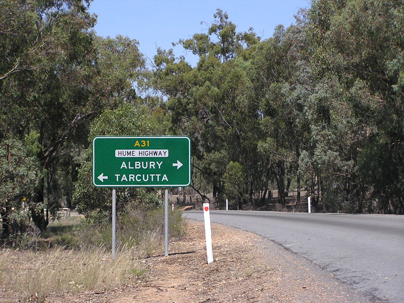
A31 sign on the Hume Highway at Mates Gully Rd near Tarcutta. If you look closely you can see that the "A31" is of the Victorian style - i.e. without a shield. Feb 2006. |
 |
B94 fingerboard sign at the western entrance to Garoolgan Rest Area on Burley Griffin Way, between Barellan and Yenda. Feb 2006. |
 |
B94 fingerboard sign at the eastern entrance to Garoolgan Rest Area on Burley Griffin Way, between Barellan and Yenda. Feb 2006. |
 |
"B64" signage for Mid Western Highway at its junction with Cobb Highway in Hay. March 2006. (Richard Wardle) |
 |
"B75" signage for Cobb Highway at its junction with Mid Western Highway in Hay. March 2006. (Richard Wardle) |
 |
"B75" signage for Cobb Highway at its junction with Mid Western Highway in Hay. March 2006. (Richard Wardle) |
 |
"B55" signage for Castlereagh Highway at the junction with King St, Coonamble. April 2006. |
 |
More B55 signage for Castlereagh Hwy at the same intersection. April 2006. |
 |
Another B55 sign, this time facing southbound Castlereagh Hwy traffic at King St in Coonamble. April 2006. |
 |
More B55 signage, this time a fingerboard sign at Bate St in Walgett. April 2006. |
 |
B55 distance sign, southbound on Castlereagh Hwy outside Walgett District Hospital. Note the inclusion of "Dubbo" as the remote focal point, reflecting the orientation of the route is not towards Mudgee, Lithgow and Sydney despite the Castlereagh Hwy continuing that way. April 2006. |
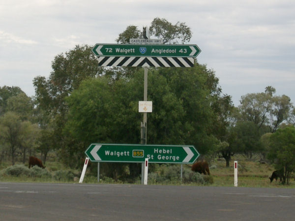
More B55 signage, this time a pair of fingerboard signs at the junction of Castlereagh Hwy and Euroka St in Walgett. April 2006. |
|
 |
B55 AD sign eastbound on Kamilaroi Hwy (Wee Waa St) approaching Castlereagh Hwy (Fox St) in Walgett. Note there is no mention of B76 - the route number shown on Kamilaroi Highway signage west of Walgett. This indicates either that the Kamilaroi Highway will have more than one route marker along its length, or that the sign designer has stuffed up, yet again! April 2006. |
 |
Distance sign heading north on the B55 (Castlereagh Hwy) towards the Namoi River bridge at Walgett. Same comments as for the above sign. Also note there is no mention of St George, which is the remote focal point on Castlereagh Hwy (another error!) and no mention of Angledool, which is mentioned on most other directional signs (although is being phased out). April 2006. |
 |
A sample of the aforementioned B76 signage, on a distance sign heading west from Walgett along the Kamiaroi Highway. April 2006. |
 |
Another B76 sign, this one a fingerboard, located near the bridge over the Namoi River, 5km west of Walgett. April 2006. |
 |
"A32" signage on Leura Mall, southbound approaching the Great Western Highway at Leura. Photo taken by Dean Jones in May 2006. |
 |
"A39" and "B51" signage on Newell Highway southbound approaching the junction with Kamilaroi Highway at West Narrabri. It appears that the Kamilaroi Highway will receive at least 2 different route markers, following the sighting of B76 signage at Walgett. Photo by Michael Gill. July 2006. |
 |
Very dodgy A1 fingerboard sign on the Pacific Highway at Glen Ora Rd, just south of Nabiac. There are several others in the Nabiac area however I wasn't able to photograph them all as I would have liked. July 2006. |
 |
A44 distance sign left uncovered on Great Western Hwy near Wallgrove Rd, Minchinbury. December 2006. |
 |
M4 AD sign southbound on Prospect Hwy approaching the M4 Motorway at Prospect. I wonder why they only covered one of the M4 shields? Sep 2006. |
 |
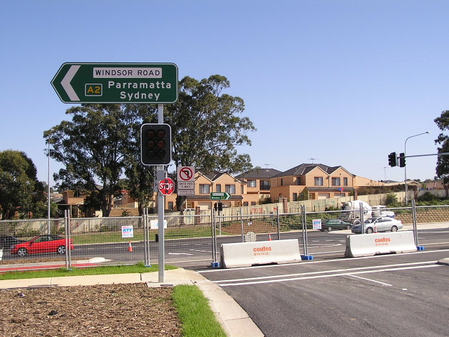
A2 ID sign on Windsor Rd at the recently signalised junction with Chapman and Bandon Roads at Vineyard. Sep 2006. |
 |
A2 ID sign on Windsor Rd at the recently signalised junction with Chapman and Bandon Roads at Vineyard. Sep 2006. |
 |
A2 ID sign on Windsor Rd at the recently signalised junction with Chapman and Bandon Roads at Vineyard. Sep 2006. |
 |
A2 ID sign on Windsor Rd at the recently signalised junction with Chapman and Bandon Roads at Vineyard. Sep 2006. |
 |
A48 fingerboard sign on the Illawarra Hwy at Church St, Burrawang. Sep 2006. |
 |
A48 distance sign on the Illawarra Hwy, heading east from Sutton Forest. Sep 2006. |
 |
B73 distance sign on Sheepwash Road, heading north from Nowra Road (SR79) near Fitzroy Falls. Sep 2006. |
 |
A2 and M7 shields on this new AD sign assembly, northbound on Old Windsor Rd approaching the newly-opened underpass at Norwest Bvd. Sep 2006. |
 |
M2 shield on the Westlink M7, heading east at the Norwest Boulevard interchange. Photo by Dean Jones, Sep 2006. |
 |
A2 sign southbound on Old Windsor Rd approaching the underpass at Norwest Boulevard. How nice of them to locate the sign behind two telegraph poles! Nov 2006. |
 |
Another A2 sign, this time facing westbound traffic, at the Old Windsor Rd/Norwest Bvd interchange. Nov 2006. |
 |
A1 shield on a northbound gantry, Pacific Highway approaching Longueville Rd at Artarmon. Nov 2006. |
 |
M1 shield for the Southern Freeway, northbound on Old Princes Highway at the Helensburgh interchange. Source: Richard Wardle, Dec 2006. |
 |
Foldable AD sign with A1 shield on it - Pacific Hwy & Bangalow Rd, Ballina. The sign is foldable to allow an alternate message to be displayed in the event of a bad accident on the highway and divert traffic via Bangalow Rd. Source: John Graham, December 2006. |
 |
Another brand-spanking-new foldable AD sign with A1 shield at Pacific Hwy/Bangalow Rd intersection in Ballina. Source: John Graham, December 2006. |
 |
AD sign at the intersection of Pacific Hwy, Brunswick Heads Rd & Brunswick Valley Way (soon to be northern Brunswick interchange) at Brunswick Heads, with 'M1' shield exposed. Source: Lachlan Sims, December 2006. |
 |
B53 and B57 shields appear on this new AD sign on Five Islands Rd, approaching The Esplanade at Speers Point. December 2006. |
 |
B53 ID sign at the intersection of Five Islands Rd, Toronto Rd, First Ave & York St, Booragul. December 2006. |
 |
B53 AD sign on York St at the intersection of Five Islands Rd, Toronto Rd, First Ave & York St, Booragul. December 2006. |
 |
A1 AD sign northbound on Pacific Highway approaching Myall Way, about 12km north of Karuah. December 2006. |
 |
A1 RD sign northbound on Pacific Highway after Myall Way, about 12km north of Karuah. December 2006. |
 |
A1 AD sign southbound on Pacific Highway approaching the Nabiac interchange. December 2006. |
 |
A32 AD sign on Mitchell Highway (Maughan St) westbound approaching the junction with Renshaw-McGirr Way in Wellington. December 2006. |
 |
A32 ID sign, poorly designed, facing eastbound Mitchell Hwy traffic at the junction with Renshaw-McGirr Way in Wellington. December 2006. |
 |
A32 ID sign, poorly designed, facing northbound Mitchell Hwy traffic at the junction with Renshaw-McGirr Way in Wellington. December 2006. |
 |
A39 ID sign on Newell Hwy at the junction with Purvis Lane, 5km north of Dubbo. December 2006. |
 |
A39 sign on Newell Hwy near the junction with Purvis Lane, 5km north of Dubbo. December 2006. |
 |
A39 sign northbound on Darling St approaching Newell Hwy (Erskine St) in Dubbo. December 2006. |
 |
B87 fingerboard sign at the junction of Kidman Way and an unnamed road, 3km south of Hillston. December 2006. |
 |
A1 sign on Pacific Hwy at the junction with Bangalow Rd in Ballina. Note the sign is foldable so that it can show an alternative message when the highway is closed due to an accident. Source: John Graham, December 2006. |
 |
B57 ID sign at the intersection of Five Islands Road, TC Frith Ave & The Esplanade, Speers Point. Feb 2007. |
 |
B53 ID sign at the intersection of Five Islands Road, Toronto Rd, First Ave & York St, Booragul. Feb 2007. |
 |
A2 double-chevron ID sign on Windsor Rd at the junction with Boundary Rd, Vineyard. Feb 2007. |
 |
A2 distance sign on Windsor Rd, heading east from Garfield Rd East at Box Hill. Feb 2007. |
 |
A48 distance sign on Illawarra Highway, heading west from Church Street at Burrawang. Feb 2007. Source: Richard Wardle |
 |
'A8' signage - finally! Thanks to Bernard Ng for spotting this and thanks to me for going out and taking the photo :p March 2007. |
 |
'M1' sign above the Lane Cove Tunnel eastbound exit to Pacific Highway and the Gore Hill Freeway transit lane, Artarmon. March 2007. |
 |
'A1' AD sign northbound on Pacific Highway approaching the interchange at Nabiac. Jan 2007. Source: Dave Whiteman |
 |
'M2' lane allocation AD sign, westbound on the Hills (M2) Motorway approaching the Epping Tunnel. March 2007. |
 |
'M2' shield on a toll charges sign for the Lane Cove Tunnel, westbound on Gore Hill Freeway at Artarmon. March 2007. |
 |
'A2' shield on an AD sign, south-eastbound on Windsor Road approaching Sanctuary Drive at Rouse Hill. March 2007. |
 |
'M2' shield on a toll charges sign for the Lane Cove Tunnel, eastbound on Epping Road at North Ryde. April 2007. |
 |
'M2' shield on a lane allocation AD sign, westbound on the Hills (M2) Motorway approaching the Beecroft Road exit. April 2007. |
 |
'B60' shield on Bruxner Highway distance sign, heading east from Tenterfield. April 2007. Source: Michael Gill. |
 |
'A2' shield on an ID sign at the intersection of Windsor Rd & Sanctuary Dr, Rouse Hill. May 2007. |
 |
'A2' shield on an ID sign at the intersection of Windsor Rd & Sanctuary Dr, Rouse Hill. May 2007. |
 |
'A2' shield on a RD sign on Windsor Rd, heading north-west from Garfield Rd East, Box Hill. Source: Paul Mech, July 2007. |
 |
'A32' shield on an AD sign on Great Western Highway, westbound approaching Leura Mall, Leura. Source: Paul Rands, July 2006. |
 |
'A2' ID sign at the intersection of Old Windsor Rd & Norwest Boulevard, Bella Vista. May 2007. |
 |
'M1' ID sign at the intersection of Pacific Highway & Main Street, Billinudgel. Source: Paul Rands, July 2007. |
 |
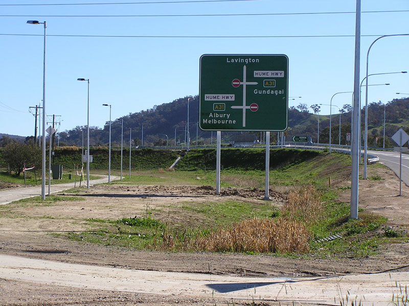
'A31' AD sign southbound on Hume Highway approaching the Wagga Rd (old Hume Hwy) interchange at Ettamogah, the northern end of the Albury Bypass. July 2007. |
 |
'A31' ID sign at the Hume Highway/Wagga Rd interchange, Ettamogah. July 2007. |
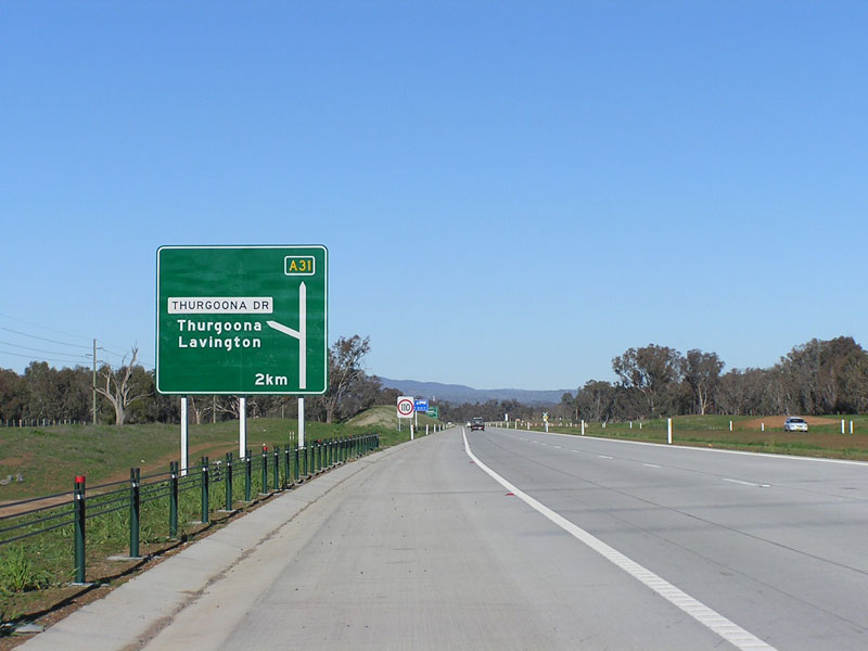 |
'A31' AD sign southbound on Hume Hwy approaching Thurgoona Dr, on the Albury Bypass. July 2007. |
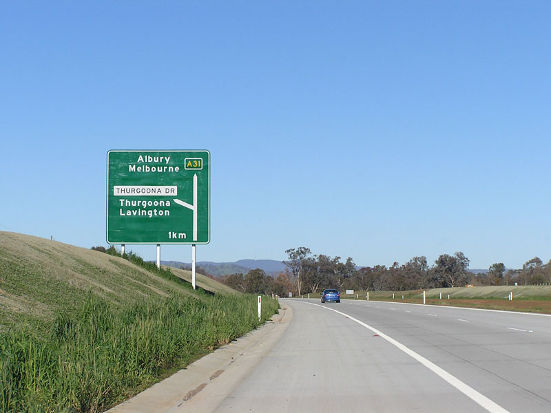 |
'A31' AD sign southbound on Hume Hwy approaching Thurgoona Dr, on the Albury Bypass. July 2007. |
 |
'A31' and 'B58' shields on this AD sign southbound on Hume Hwy approaching Riverina Hwy (Borella Rd), Albury. July 2007. |
 |
'B58' supplementary AD sign heading south on Hume Hwy approaching Riverina Hwy at Albury. July 2007. |
 |
'A31' and 'B58' shields on this AD sign southbound on Hume Hwy approaching Riverina Hwy (Borella Rd), Albury. July 2007. |
 |
'B58' ID sign southbound on Hume Hwy at the Riverina Hwy interchange, Albury. July 2007. |
 |
'B58' AD sign on the southbound off-ramp from Hume Hwy to Riverina Hwy, Albury. July 2007. |
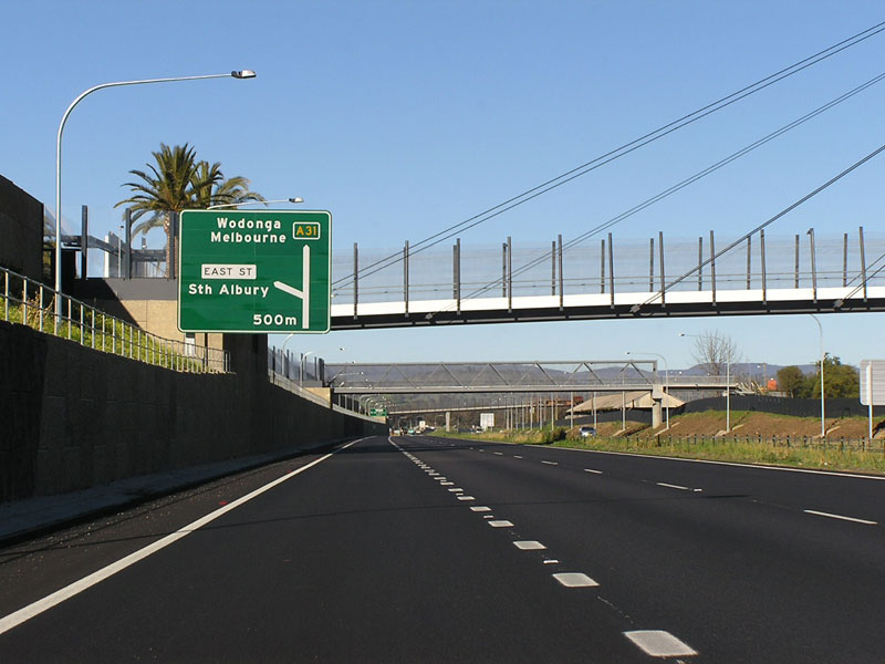 |
'A31' AD sign southbound on Hume Hwy approaching East St interchange, Albury. July 2007. |
 |
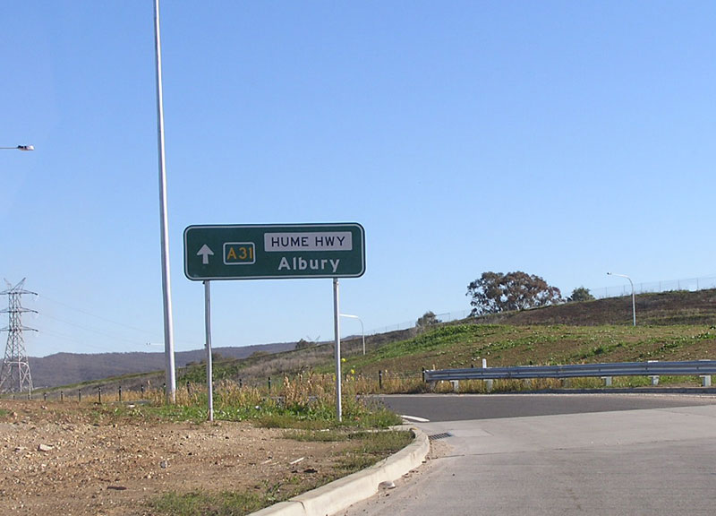
'A31' AD sign southbound on Hume Hwy approaching the Victorian Border at Albury - this is the last directional sign on Hume Hwy inside NSW. July 2007. |
 |
'A31' AD sign northbound on Hume Hwy, just after crossing from Victoria into NSW. July 2007. |
 |
'A31' ID sign facing westbound traffic at the Hume Hwy/East St interchange, Albury. July 2007. |
 |
'A31' ID sign facing eastbound traffic at the Hume Hwy/East St interchange, Albury. July 2007. |
 |
'A31' AD sign westbound on East St approaching Hume Hwy, Albury. July 2007. |
 |
'A31' ID sign facing westbound traffic at the Hume Hwy/East St interchange, Albury. July 2007. |
 |
'A31' ID sign facing eastbound traffic at the Hume Hwy/East St interchange, Albury. July 2007. |
 |
Sun-affected photo of a 'B58' supplementary AD sign, northbound on Hume Hwy approaching Riverina Hwy, Albury. July 2007. |
 |
'B58' ID sign northbound on Hume Hwy approaching Riverina Hwy, Albury. July 2007. |
 |
'B58' ID sign facing northbound traffic at the Hume Hwy/Riverina Hwy interchange, Albury. July 2007. |
 |
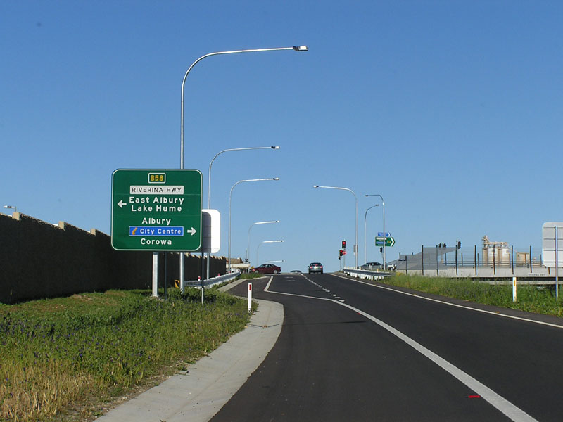
AD sign eastbound on Riverina Hwy approaching Hume Hwy at Albury. Note the absence of a B58 shield. July 2007. |
'A31' ID sign facing eastbound traffic at the Hume Hwy/Riverina Hwy junction, Albury. July 2007. |
|
 |
'A31' ID sign facing westbound traffic at the Hume Hwy/Riverina Hwy junction, Albury. July 2007. |
 |
'B58' ID sign facing southbound traffic at the Hume Hwy/Riverina Hwy junction, Albury. July 2007. |
 |
'B58' ID sign facing southbound traffic at the Hume Hwy/Riverina Hwy junction, Albury. July 2007. |
 |
AD sign westbound on Riverina Hwy approaching the Hume Hwy junction, Albury. Note the absence of a B58 shield. July 2007. |
 |
'A31' ID sign facing westbound traffic at the Hume Hwy/Riverina Hwy junction, Albury. July 2007. |
 |
'A31' ID sign facing eastbound traffic at the Hume Hwy/Riverina Hwy junction, Albury. July 2007. |
 |
'B58' ID sign facing northbound traffic at the Hume Hwy/Riverina Hwy junction, Albury. July 2007. |
 |
'A31' AD sign northbound on Hume Hwy approaching Racecourse Rd, Albury. July 2007. |
 |
'A31' AD sign northbound on Hume Hwy approaching Racecourse Rd, Albury. July 2007. |
 |
'A31' AD sign northbound on Hume Hwy approaching Thurgoona Dr on the Albury Bypass. July 2007. |
 |
'A31' ID sign facing eastbound traffic at the Hume Hwy/Thurgoona Dr interchange, on the Albury Bypass. July 2007. |
 |
'A31' ID sign facing westbound traffic at the Hume Hwy/Thurgoona Dr interchange, on the Albury Bypass. July 2007. |
 |
'A31' AD sign eastbound on Thurgoona Dr, approaching Hume Hwy, Lavington. July 2007. |
 |
'A31' AD sign westbound on Thurgoona Dr, approaching Hume Hwy, Lavington. July 2007. |
 |
'A31' ID sign facing westbound traffic at the Hume Hwy/Thurgoona Dr interchange, Lavington. July 2007. |
 |
'A31' ID sign facing eastbound traffic at the Hume Hwy/Thurgoona Dr interchange, Lavington. July 2007. |
 |
'A31' ID sign facing southbound traffic at the intersection of Union Rd & Dallinger Rd & Racecourse Rd, the latter leading to the Hume Hwy. July 2007. |
 |
'A31' ID sign facing northbound traffic at the intersection of Union Rd & Dallinger Rd & Racecourse Rd, the latter leading to the Hume Hwy. July 2007. |
 |
'A31' AD sign, eastbound on Racecourse Rd as it approaches the junction with Corrys Rd, Dallinger Rd & the southbound on-ramp to Hume Hwy. July 2007. |
 |
'A31' AD sign, northbound on Dallinger Rd approaching the junction with Corrys Rd, Racecourse Rd & Hume Hwy. July 2007. |
 |
'A31' ID sign at the southbound on-ramp from Racecourse Rd to Hume Hwy. July 2007. |
 |
'A31' AD sign northbound on Wagga Rd (old Hume Hwy), approaching Hume Hwy at Ettamogah. July 2007. |
 |
'A31' distance sign heading north on Hume Hwy at Ettamogah. July 2007. |
 |
Incorrectly designed 'A41' fingerboard sign on Olympic Highway at Wallacetown. Source: Richard Wardle, August 2007. |
 |
New directional sign indicating the beginning of the Hills Motorway, complete with 'M2' shield, eastbound at Abbott Road. Source: Conrad Zalewski, August 2007. |
 |
Brand-spanking new AD sign on Schofields Rd approaching Windsor Rd at Rouse Hill, complete with uncovered 'A2' shield. Stage 1 of the Rouse Hill Town Centre is due for opening on 25 September. Photo taken September 2007. |
 |
ID sign with A2 shield uncovered at the intersection of Windsor Rd, Schofields Rd & Rouse Hill Dr, Rouse Hill. Photo taken September 2007. |
 |
ID sign with A2 shield uncovered at the intersection of Windsor Rd, Schofields Rd & Rouse Hill Dr, Rouse Hill. Photo taken September 2007. |
 |
ID sign with A2 shield uncovered at the intersection of Windsor Rd, Schofields Rd & Rouse Hill Dr, Rouse Hill. Photo taken September 2007. |
 |
ID sign with A2 shield uncovered at the intersection of Windsor Rd, Schofields Rd & Rouse Hill Dr, Rouse Hill. Photo taken September 2007. |
 |
ID sign with 'B73' shield at the junction of Nowra Rd & Sheepwash Rd, 2km north of Fitzroy Falls. Source: Richard Wardle, September 2007. |
 |
ID sign with 'B73' shield at the junction of Nowra Rd & Sheepwash Rd, 2km north of Fitzroy Falls. Source: Richard Wardle, September 2007. |
 |
A2 AD sign northbound on Windsor Rd approaching Schofields Rd at Rouse Hill. Note the spelling mistake of "Schofield". Photo taken September 2007. |
 |
A9 ID sign at the intersection of Hawkesbury Valley Way & Macquarie St, Windsor. Photo taken September 2007. |
 |
A2 AD sign eastbound on Hawkesbury Valley Way approaching the connection to Mulgrave Rd at Mulgrave. Photo taken September 2007. |
 |
A15 ID sign on New England Highway at the junction with Golden Highway, between Branxton and Singleton. Photo taken September 2007. |
 |
M1 AD sign southbound on Pacific Highway approaching the junction with Tweed Valley and Brunswick Valley Ways, Yelgun. Photo taken September 2007. |
 |
A1 fingerboard sign on Pacific Highway at Range Rd, Dirty Creek Range. Photo taken October 2007. |
 |
A1 fingerboard sign on Pacific Highway at Possum Brush Rd, Nabiac. Photo taken October 2007. |
 |
A1 fingerboard sign on Pacific Highway at Possum Brish Rd, Nabiac. Photo taken October 2007. |
 |
M5 shield on an overhead sign - Hume Highway northbound at the interchange with the South Western & Westlink motorways. Photo taken November 2007. |
 |
A32 shield on a fingerboard sign on Mitchell Highway at Molong Creek, 5km north of Molong. Photo taken November 2007. |
 |
A32 ID sign at the intersection of Mitchell Hwy & Darling St, Dubbo. Photo taken November 2007. |
 |
What appears to be a 'B80' sticker on top of a NR23 coverplate, southbound on Monaro Hwy approaching the junction with Snowy Mountains Hwy near Nimmitabel. This sign was previously photographed with a NR23 coverplate. Photo taken November 2007. |
 |
B75 distance sign heading north from Hay along Cobb Highway. Source: Paul Rands, December 2007. |
 |
AD sign with B64 and B75 shields southbound on Cobb Highway approaching Mid Western Highway, Hay. Source: Paul Rands, December 2007. |
 |
B75 AD sign westbound on Mid Western Highway approaching the Cobb Highway, Hay. Source: Paul Rands, December 2007. |
 |
B75 ID sign at the intersection of Mid Western Highway & Cobb Highway, Hay. Source: Paul Rands, December 2007. |
 |
B64 ID sign at the intersection of Mid Western Highway & Cobb Highway, Hay. Source: Paul Rands, December 2007. |
 |
B75 ID sign at the intersection of Mid Western Highway & Cobb Highway, Hay. Source: Paul Rands, December 2007. |
 |
M4 distance sign heading west from Wallgrove Road, Eastern Creek. The westbound on-ramp from the Westlink M7 is to the left of the sign. Photo taken December 2007. |
  |
Two photographs of a B55 sign on Castlereagh Highway, southbound at Lidsdale. It is unusual that all other directional signs in the area had B55 covered with a State Route 86 coverplated, yet this sign only had a poor attempt at placing gaffer tape over the route marker. Photo taken December 2007. |
 |
B69 fingerboard sign at the intersection of Appin Road & Baden Powell Drive, 7km south east of Appin. Photo taken January 2008. |
 |
A31 AD sign on Mates Gully Road approaching Hume Highway, 2km south of Tarcutta. Note that this sign is very non-standard - i.e. all capitals and no border around the A31. Photo taken January 2008. |
 |
B56 AD sign westbound on Gordon Street, approaching the beginning of Oxley Highway at Port Macquarie. Photo taken January 2008. |
 |
B56 AD sign northbound on Hindman Street, approaching the intersection with Oxley Highway, Hastings River Drive & Gordon Street, Port Macquarie. Photo taken January 2008. |
 |
B56 ID sign at the intersection of Oxley Highway, Hastings River Drive, Gordon Street & Hindman Street, Port Macquarie. Photo taken January 2008. |
 |
B56 ID sign at the intersection of Oxley Highway, Hastings River Drive, Gordon Street & Hindman Street, Port Macquarie. Photo taken January 2008. |
 |
B56 AD sign southbound on Hastings River Drive, approaching the intersection with Oxley Highway, Gordon Street & Hindmand Street, Port Macquarie. Photo taken January 2008. |
 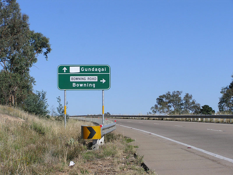 |
M31 AD sign southbound on Hume Highway, approaching the intersection with Bowning Road at Bowning. Photo taken January 2008. |
 |
B76 ID sign at the intersection of Castlereagh Highway & Kamilaroi Highway, Walgett. Source: Michael Gill, February 2008. |
 |
B85 RD sign northbound on Goldfields Way after the junction with Olympic Highway, 5km west of Junee. Source: Richard Wardle, February 2008. |
 |
B85 AD sign northbound on Goldfields Way approaching the junction with Gundagai Road, Old Junee. Source: Richard Wardle, February 2008. |
 |
B85 ID sign at the intersection of Goldfields Way & Gundagai Road, Old Junee. Source: Richard Wardle, February 2008. |
 |
B85 ID sign at the intersection of Goldfields Way & Gundagai Road, Old Junee. Source: Richard Wardle, February 2008. |
 |
M5 ID sign at the intersection of Newbridge Road & Heathcote Road, Moorebank. Photo taken Febraury 2008. |
 |
M5 ID sign at the intersection of Newbridge Road & Heathcote Road, Moorebank. Photo taken Febraury 2008. |
 |
A34 AD sign eastbound on Newbridge Road, approaching Heathcote Road at Moorebank. Photo taken February 2008. |
 |
A39 & B94 shields on an ID sign at the intersection of Newell Highway & Burley Griffin Way, Mirrool. Source: Richard Wardle, April 2004. |
 |
A39 shield on an ID sign at the intersection of Newell Highway & Coolamon-Ardlethan Road, Ardlethan. Source: Richard Wardle, February 2005. |
 |
Non-standard A41 sign on Olympic Highway between Henty and Culcairn. Source: Richard Wardle, March 2008. |
 |
M1 shield on an ID sign southbound on Pacific Highway at the Gore Hill Freeway ramps, Artarmon. Photo taken, April 2008. |
 |
M2 shield uncovered on an AD sign, southbound on Old Windsor Road approaching Abbott Road, Seven Hills. Photo taken May 2008. |
 |
A1 shield uncovered on an AD sign, northbound on Pacific Highway approaching Sheehys Lane, Tyndale. Photo taken July 2008. |
 |
A1 shield uncovered on an AD sign, southbound on Pacific Highway approaching Upper Coldstream Road, Tyndale. Photo taken July 2008. |
 |
A1 shield uncovered on an AD sign, southbound on Pacific Highway approaching Sheehys Lane, Tyndale. Photo taken July 2008. |
 |
Uncovered M5, M7 and A28 shields northbound on Hume Highway approaching Camden Valley Way, Prestons. Photo taken August 2008. |
 |
A15 shield uncovered on a RD sign on New England Highway, heading south from Willow Tree. Source: Michael Gill, September 2008. |
 |
A15 shield uncovered on a RD sign on New England Highway, heading north from the northern end of the Armidale Bypass. Source: Michael Gill, September 2008. |
 |
A1 shield uncovered on an ID sign at the junction of Pacific Highway & Manning River Drive, Cundletown. Source: Michael Gill, October 2008. |
 |
A32 shield with a gold border, uncovered on an AD sign on Opal Miners Way approaching Barrier Highway, Wilcannia. Source: Philip McCallum, April 2008. |
 |
B87 shield on a fingerboard sign on Kidman Way, 49km south of Bourke. Source: Tim Cole, April 2008. |
 |
B64 shield uncovered on an ID sign at the intersection of Mid Western Highway & Kidman Way, Goolgowi. Source: Tim Cole, April 2008. |
 |
B87 shield uncovered on an ID sign at the intersection of Sturt Highway & Kidman Way, Waddi. Source: Tim Cole, April 2008. |
 |
A39 shield on a fingerboard sign at the intersection of Newell Highway & Cenn Cruaich Road, Gowang. Source: Ben Zoffman, May 2008. |
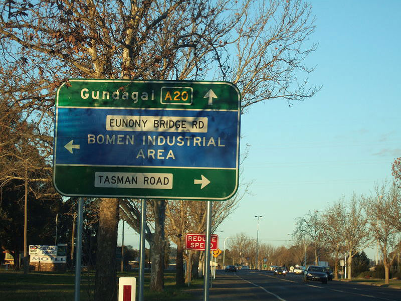 |
A20 shield on an AD sign, eastbound on Sturt Highway approaching Eunony Bridge Road & Tasman Road, Gumly Gumly. Source: Rick Wardle, July 2008. |
 |
A20 shield on an AD sign, westbound on Sturt Highway approaching Eunony Bridge Road & Tasman Road, Gumly Gumly. Source: Rick Wardle, July 2008. |
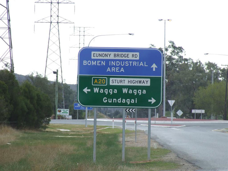 |
A20 shield on an AD sign, northbound on Tasman Road approaching Sturt Highway & Eunony Bridge Road, Gumly Gumly. Source: Rick Wardle, July 2008. |
 |
A20 shield on an AD sign, at the intersection of Sturt Highway, Eunony Bridge Road & Tasman Road, Gumly Gumly. Source: Rick Wardle, July 2008. |
 |
A20 shield on an AD sign, at the intersection of Sturt Highway, Eunony Bridge Road & Tasman Road, Gumly Gumly. Source: Rick Wardle, July 2008. |
 |
A20 shield on a RD sign, on Sturt Highway heading west from Eunony Bridge Road & Tasman Road, Gumly Gumly. Source: Rick Wardle, July 2008. |
  |
A41 shields on twin AD signs, southbound on Olympic Highway approaching Camp Access Road at Kapooka. Source: Rick Wardle, August 2008. |
 |
A32 shield on an ID sign at the intersection of Mitchell Highway & Dandaloo Street, Narromine. Source: Rick Wardle, September 2008. |
 |
A32 shield on an ID sign at the intersection of Mitchell Highway & Culling Street, Narromine. Source: Rick Wardle, September 2008. |
 |
A32 shield on a RD sign, on Mitchell Highway heading west from Narromine. Source: Rick Wardle, September 2008. |
 |
B72 shield on an ID sign at the intersection of Snowy Mountains Highway & Wondalga Road, Adelong. Source: Rick Wardle, October 2008. |
 |
B72 shield on a RD sign, on Snowy Mountains Highway heading west from Tumut. Source: Rick Wardle, October 2008. |
 |
B64 shield uncovered on an ID sign at the intersection of Mid Western Highway & Showground Road, West Wyalong. Source: Tim Cole, November 2008. |
 |
A15 shield on an ID sign at the intersection of New England Highway & Weakleys Drive, Beresfield. Photo taken November 2008. |
 |
A15 shield on an ID sign at the intersection of New England Highway & Weakleys Drive, Beresfield. Photo taken November 2008. |
 |
M1 shield on an ID sign at the intersection of New England Highway & Weakleys Drive, Beresfield. Photo taken November 2008. |
 |
A15 shield on an ID sign at the intersection of New England Highway & Weakleys Drive, Beresfield. Photo taken November 2008. |
 |
A15 shield on an ID sign at the intersection of New England Highway & Weakleys Drive, Beresfield. Photo taken November 2008. |
 |
A1 shield on an ID sign, adjacent to Pacific Highway at the Wallanbah Road/Clarkson Street interchange, Nabiac. Photo taken November 2008. |
 |
B85 shield on a fingerboard sign at the intersection of Goldfields Way & Reefton-Ariah Park Road, 9km south of Barmedman. Photo taken November 2008. |
 |
This is rather unusual - a print-out of a sign design for the AD sign eastbound on Mid Western Highway approaching Lachlan Street, Cowra. The sign design, located on the rear of the sign, shows A41 and B81 shields, however coverplates have been placed on the signface. Photo taken November 2008. |
 |
A41 shield uncovered on an AD sign, westbound on Mid Western Highway approaching the junctions with Lachlan Valley Way & Olympic Way, Cowra. Photo taken November 2008. |
 |
A41, B64 and B81 shields uncovered on an ID sign assembly, at the intersection of Mid Western Highway & Lachlan Valley Way, Cowra. Photo taken November 2008. |
 |
A41 and B64 shields uncovered on an ID sign assembly, at the intersection of Mid Western Highway & Olympic Highway, Cowra. Photo taken November 2008. |
 |
This is rather unusual - a print-out of a sign design for the AD sign eastbound on Bridge Street approaching Lachlan Street, Cowra. The sign design, located on the rear of the sign, shows B81 shield, however a coverplate has been placed on the signface. Photo taken November 2008. |
 |
B64 shield uncovered on an AD sign, northbound on Olympic Highway approaching Mid Western Highway, Cowra. Photo taken November 2008. |
 |
B58 shield on an ID sign at the intersection of Riverina Highway & Honour Avenue, 6km east of Corowa. Source: Rick Wardle, December 2008. |
 |
B58 shield on an ID sign at the intersection of Riverina Highway & Honour Avenue, 6km east of Corowa. Source: Rick Wardle, December 2008. |
 |
A32 shield on an ID sign at the intersection of Mitchell Highway & Northern Distributor Road, Orange. Photo taken December 2008. |
 |
A15 shield with a gold border, on an ID sign at the intersection of New England Highway & Rocky River Road, 4km north of Uralla. Photo taken December 2008. |
 |
A32 shield with gold border on an ID sign at the intersection of Barrier Highway & Opal Miners Way, Wilcannia. Source: Chris Eastwood, December 2008. |
 |
A32 shield with gold border on an AD sign, westbound on Barrier Highway approaching Opal Miners Way, Wilcannia. Source: Chris Eastwood, December 2008. |
 |
A32 shield with gold border on a RD sign, on Barrier Highway heading west from Wilcannia. Source: Chris Eastwood, December 2008. |
 |
M1 shield uncovered on an ID sign at the Tuggerah Interchange on Sydney-Newcastle Freeway. Source: Adam Sadler, February 2009. |
 |
B84 shield uncovered on a RD sign on Golden Highway, heading east from Dunedoo. This sign should also have a B55 shield on it, as this sign lies on the B55/B84 duplex. Source: Ben Zoffman, January 2009. |
 |
A32 shields uncovered on ID signs at the intersection of Great Western Highway & Woodlands Road, Katoomba. Source: Winston Yang, March 2009. |
 |
B65 shield uncovered on a RD sign on the soon-to-be-opened Northern Distributor extension, Bellambi. Source: Dean Jones, May 2009. |
 |
A31 shield uncovered on an AD sign southbound on Hume Highway approaching the Tumbarumba Rd interchange between Tarcutta and Holbrook. Source: Tim Cole, April 2009. |
A31 shield uncovered on a RD sign southbound on Hume Highway leaving the Tumbarumba Rd interchange between Tarcutta and Holbrook. Source: Tim Cole, April 2009. |
|
 |
A15 shield uncovered on an AD sign on New England Highway at Greg Norman Drive, Tamworth. Source: Michael Gill, June 2009. |
 |
A15 shield uncovered on an ID sign on New England Highway at Greg Norman Drive, Tamworth. Source: Michael Gill, June 2009. |
 |
M1 shield uncovered on an AD sign on Sparks Rd approaching the Sydney-Newcastle Freeway at Warnervale. Photo taken: July 2009. |
 |
M1 shield uncovered on an ID sign at the junction of Hue Hue Rd & Sparks Rd, Warnervale. Photo taken: July 2009. |
 |
M1 shield uncovered on an AD sign northbound on Hue Hue Rd approaching the junction with Sparks Rd at Warnervale. Photo taken: July 2009. |
 |
A31 shield uncovered on an AD sign southbound on Hume Highway approaching the Olympic Highway interchange at Table Top. Source: Rick Wardle, July 2009. |
 |
A41 shield uncovered on an AD sign northbound on Olympic Highway at Wagga Wagga. Source: Tim Cole, July 2009. |
 |
B88 shield uncovered on an AD sign eastbound on Picton Road near Wilton. Source: Mitch, July 2009. |
 |
M1 shield uncovered on an AD sign southbound on Wyee Rd approaching Hue Hue Rd, Wyee. Source: Adam Sadler, August 2009. |
 |
M1 shield uncovered on an ID sign at the intersection of Wyee Rd & Hue Hue Rd, Wyee. Source: Adam Sadler, August 2009. |
 |
M1 shield uncovered on an ID sign at the intersection of Wyee Rd & Hue Hue Rd, Wyee. Source: Adam Sadler, August 2009. |
 |
M31 shield uncovered on a RD sign, southbound on Hume Highway near the junction with Illawarra Highway. Does this mean RTA has decided to make all the Hume M31? Photo taken: August 2009. |
 |
B52 shield uncovered on an AD sign, westbound on Kings Highway at Captains Flat Road near Queanbeyan. Photo taken: August 2009. |
 |
B87 shield uncovered on an AD sign, northbound on Kidman Way approaching Lachlan Valley Way, 27km east of Hillston. Source: Rick Wardle, July 2009. |
 |
B76 shield uncovered on an ID sign at the intersection of Kamilaroi Highway, Belmore Street & Bathurst Street, Brewarrina. Source: Rick Wardle, July 2009. |
 |
B76 shield uncovered on an ID sign at the intersection of Castlereagh Highway & Kamilaroi Highway, Walgett. Source: Rick Wardle, July 2009. |
 |
B55 shield uncovered on a RD sign, southbound on Castlereagh Highway near Bill O'Brien Way, Lightning Ridge. Source: Rick Wardle, July 2009. |
 |
M1 shield uncovered on an ID sign at the intersection of Pacific Highway & Ross Lane, Knockrow. Source: Lachlan Sims, September 2009. |
 |
M1 shield uncovered on an ID sign at the intersection of Pacific Highway & Ross Lane, Knockrow. Source: Lachlan Sims, September 2009. |
 |
A15 shield on an ID sign at the intersection of New England Highway & Anderson Drive (west), Beresfield. Photo taken September 2009. |
 |
B64 shield uncovered on an AD sign on Mid Western Highway at Rankins Springs. Source: Elizabeth Dodd, October 2009. |
 |
A15 shield uncovered on an AD sign on Greg Norman Drive at New England Highway, Tamworth. Source: Paul Rands, October 2009. |
 |
A15 shield uncovered on an ID sign at the intersection of Greg Norman Drive & New England Highway, Tamworth. Source: Paul Rands, October 2009. |
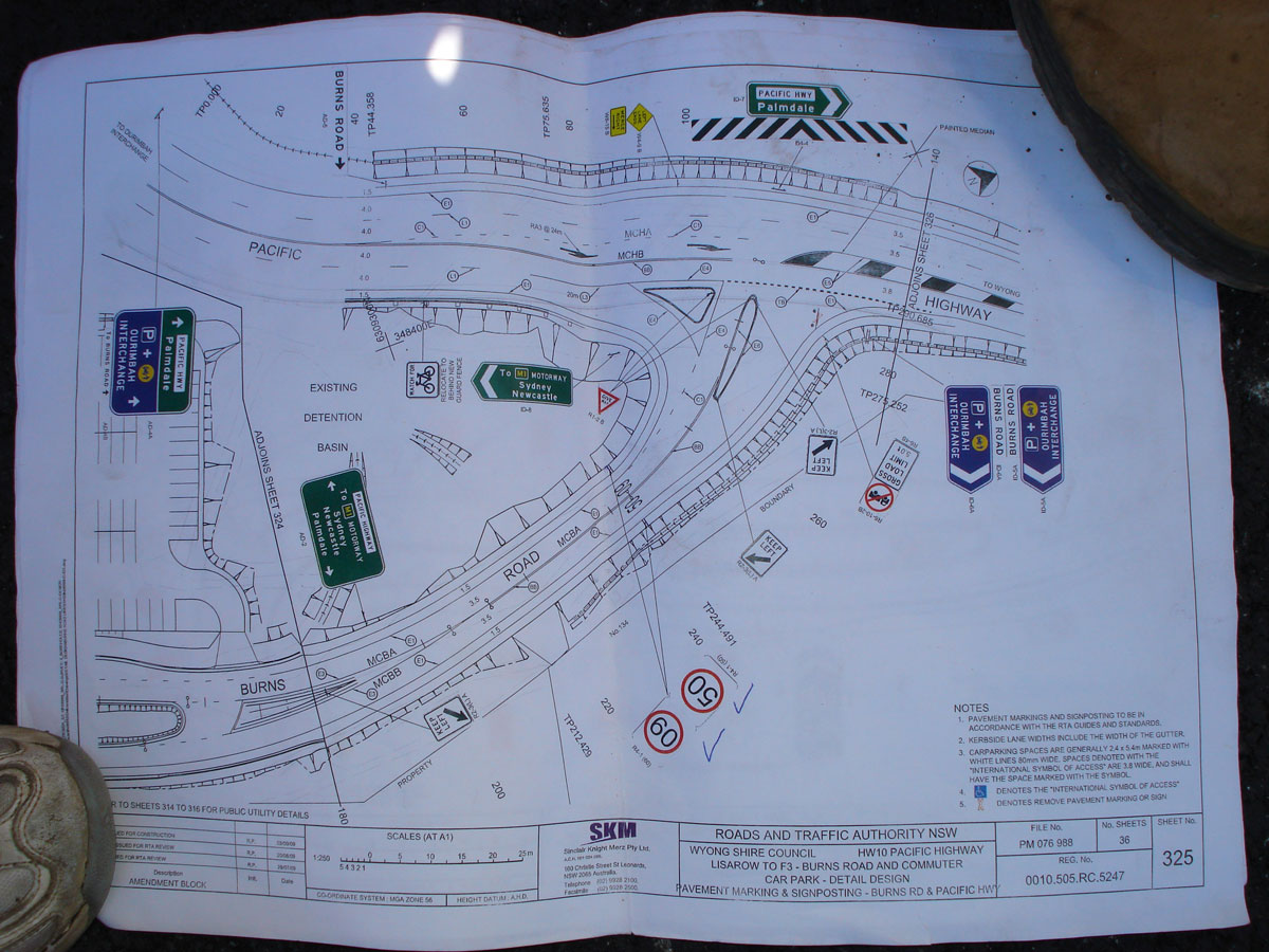 |
Signposting plan showing signage erected at the intersection of Pacific Highway & Burns Rd deviation, Ourimbah. These signs were subsequently erected with appropriate coverplating. Source: Adam Sadler, October 2009. |
 |
A22 route marker uncovered on Hume Highway at Bankstown. Photo taken: November 2009. |
 |
A22 route marker uncovered on Great Western Highway at Camperdown. Photo taken: November 2009. |
B65 route marker uncovered on an ID sign at the Northern Distributor/Park Rd junction, Woonona. Source: Paul Rands, December 2009. |
|
 |
A1 route marker uncovered on an ID sign at the Pacific Highway/Ocean Drive interchange on the newly-opened Kew bypass. Photo taken: December 2009. |
 |
A1 route marker uncovered on an AD sign on Pacific Highway at Eight Mile Lane, 12km south of Grafton. Photo taken: December 2009. |
 |
A1 route marker uncovered on an AD sign on Pacific Highway at Eight Mile Lane, 12km south of Grafton. Photo taken: December 2009. |
 |
A1 route marker uncovered on an AD sign eastbound on Ocean Drive approaching Pacific Highway at Kew. Photo taken: December 2009. |
 |
A1 route marker uncovered on a RD sign, heading south on Pacific Highway from Kew. Photo taken: December 2009. |
 |
A1 route marker uncovered on a RD sign, heading south on Pacific Highway from Johns River. |
 |
A1 route marker uncovered on a fingerboard sign at the junction of Pacific Highway & Hannamvale Rd, Moorland. Photo taken: December 2009. |
 |
A1 route marker uncovered on a RD sign, southbound on Pacific Highway at Chinderah. Source: Rob Tilley, December 2009. |
To view photos of alpha-numeric signage from 2010 onwards, click HERE. |
|
Last updated 26 March 2011.
© Ozroads 2004-2011.