NSW Route A36 Broadway - Newtown - Kogarah |
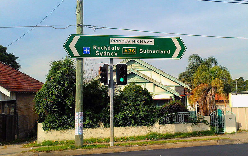
A36 ID sign at the junction of Princes Highway & Harrow Road, Kogarah. Source: Daniel Thornton, June 2013.
Introduced: June 2013
Replaced: State Route 54 (Broadway to Enmore Road)
Length: 11km
Northern Terminus: Broadway & City Road, Glebe
Southern Terminus: Princes Highway & President Avenue, Kogarah
Route taken: City Road, King Street, Princes Highway
Focal Points: Sydney, Newtown, Rockdale, Sutherland
Roads Act 1993 classification: Highway No. 1
Notable Events:
September 2012 - Alpha-numeric route marking scheme announced by RMS
April 2013 - first uncovered A36 'topknots' photographed by Brendan Terrett at Rockdale
June 2013 - route A36 fully signposted, except for section between Newtown and Broadway which was incorrectly signed as part of A34
July 2013 - incorrect A34 route markers coverplated with correct A36 route markers
Description:
Coming soon...
History:
Coming soon...
Signage:
When the coverplates were removed to unveil route A36 in late May/early June 2013, the coverplates on several signs along City Road were left on. This prompted questions about whether RMS had made a mistake. Both the maps provided to the public and the data provided to mapmakers clearly showed that route A34 terminates at Newtown and route A36 continues north along King Street and City Road to terminate at Broadway.
When the coverplates along route A34 were removed a couple of weeks later in mid June 2013, the mistake was evident as signs along City Road showed A34 instead of A36.
Perhaps RMS had confused itself? This section of road was previously part of State Route 66 which was decommisioned in 2004 and the State Route 54 extended from Newtown to Broadway. A36 was not originally included in the alpha-numeric route marking scheme so, under the original plan, A34 would have extended from Newtown to Broadway. However, the maps released by RMS as part of the September 2012 announcement clearly showed A36 extending to Broadway, as does the data provided to mapmakers. Somewhere along the line, someone has missed that these signs need fixing.
Following several complaints from the public, RMS coverplated the erroneous A34 route markers with the correct A36 route markers in July 2013.
|
Photos of route A36 - Broadway to Kogarah |
|
  |
AD sign westbound on Broadway approaching the junction with City Road. The top photo shows the incorrect A34 route marker which was unveiled in June 2013. Following several complaints from the public, RMS coverplated the sign to correctly show A36. Top photo: Anthony Rassias, June 2013. Bottom photo: Anthony Rassias, July 2013. |
  |
AD sign eastbound on Broadway approaching the junction with City Road, Glebe. The top photo shows the incorrect A34 route marker which was unveiled in June 2013. Following several complaints from the public, RMS coverplated the sign to correctly show A36. Top photo: Anthony Rassias, June 2013. Bottom photo: Anthony Rassias, July 2013. |
   |
ID sign facing westbound traffic at the junction of Broadway & City Road, Glebe. The top photo shows that in early June the route marker was still covered, despite the remainder of the route being mostly uncovered. The reason for this was evident a couple of weeks later when the coverplate was removed to reveal an incorrect A34 route marker. Following several complaints from the public, RMS coverplated the sign to correctly show A36. Top photo: Anthony Rassias, June 2013. Middle photo: Anthony Rassias, June 2013. Bottom photo: Anthony Rassias, July 2013. |
  |
ID sign facing eastbound traffic at the junction of Broadway & City Road, Glebe. The top photo shows the incorrect A34 route marker which was unveiled in June 2013. Following several complaints from the public, RMS coverplated the sign to correctly show A36. Top photo: Anthony Rassias, June 2013. Bottom photo: Anthony Rassias, July 2013. |
 |
AD sign northbound on City Road approaching the northern terminus of A36 at Broadway, Glebe. Note that the left turn is signed as Parramatta Road as Broadway becomes Parramatta Road only a short distance to the west. Source: Anthony Rassias, June 2013. |
  |
AD sign southbound on City Road approaching the junction with Cleveland Street, Chippendale. The top photo shows the incorrect A34 route marker which was unveiled in June 2013. Following several complaints from the public, RMS coverplated the sign to correctly show A36. Top photo: Anthony Rassias, June 2013. Bottom photo: Anthony Rassias, July 2013. |
  |
ID sign facing westbound traffic at the junction of City Road & Cleveland Street, Chippendale. The top photo shows the incorrect A34 route marker which was unveiled in June 2013. Following several complaints from the public, RMS coverplated the sign to correctly show A36. Top photo: Anthony Rassias, June 2013. Bottom photo: Anthony Rassias, July 2013. |
  |
RD sign southbound on City Road after the junction with Cleveland Street, Chippendale. The top photo shows the incorrect A34 route marker which was unveiled in June 2013. Following several complaints from the public, RMS coverplated the sign to correctly show A36. Top photo: Anthony Rassias, June 2013. Bottom photo: Anthony Rassias, July 2013. |
 |
AD sign northbound on City Road approaching Cleveland Street, Chippendale. An incorrect A34 route marker was unveiled in June 2013 on this sign however, following several complaints from the public, RMS coverplated the sign to correctly show A36. Source: Anthony Rassias, July 2013. |
  |
'Before' and 'after' photos showing the AD sign southbound on King Street approaching Enmore Road at Newtown. The top photo shows the how A36 was uncovered in early June whilst A34 was not uncovered until 3 weeks later. Source: Anthony Rassias, June 2013. |
  |
'Before' and 'after' photos showing the ID sign assembly at King Street & Enmore Road at Newtown. The top photo shows the how A36 was uncovered in early June whilst A34 was not uncovered until 3 weeks later. Source: Anthony Rassias, June 2013. |
 |
ID signs showing A36 route markers at the junction of Princes Highway, King Street & Sydney Park Road, St Peters. Source: Anthony Rassias, June 2013. |
AD sign southbound on Princes Highway approaching the junction with May Street, St Peters. Note that 'A36 Rockdale' is on a coverplate covering Rockdale/Wollongong and a blank coverplate over the former State Route 66, as shown here. Source: Anthony Rassias, June 2013. |
|
 |
AD sign northbound on Princes Highway approaching the junction with Sydney Park Road, St Peters. Note that although A36 continues straight ahead through Newtown, through traffic to the CBD is signed via Sydney Park Road. Source: Anthony Rassias, June 2013. |
 |
AD sign southbound on Princes Highway approaching the junction with Canal Road & May Street, St Peters. Source: Anthony Rassias, June 2013. |
 |
AD sign eastbound on Canal Road approaching the junction with Princes Highway, St Peters. Source: Anthony Rassias, June 2013. |
  |
Uncovered A36 ID signs at the junction of Princes Highway, Canal Road & May Street, St Peters. Source: Anthony Rassias, June 2013. |
 |
Coverplated AD sign southbound on Princes Highway approaching the junction with Railway Road, Sydenham. The 'A36 Rockdale' coverplate covers Rockdale/Wollongong and a blank coverplate over State Route 66. Source: Anthony Rassias, June 2013. |
AD sign eastbound on Railway Road approaching the junction with Princes Highway, Sydenham. Source: Anthony Rassias, June 2013. |
|
 |
ID sign facing eastbound traffic at the junction of Princes Highway & Railway Road, Sydenham. Source: Anthony Rassias, June 2013. |
 |
AD sign southbound on Princes Highway approaching the junction with West Botany Street, Wolli Creek. Source: Anthony Rassias, June 2013. |
 |
AD sign southbound on Princes Highway approaching the junction with Forrest Road & Wickham Street, Arncliffe. Source: Anthony Rassias, June 2013. |
  |
The first uncovered A36 route markers to appear were these two topknots at the junction of Princes Highway, Bay Street & The Sevenways, Rockdale. The ID signs were inexplicably designed and installed without provision for A36 route markers. Source: Brendan Terrett, April 2013. |
 |
ID sign facing eastbound traffic at the junction of Princes Highway & Harrow Road, Kogarah. Source: Daniel Thornton, June 2013. |
 |
ID sign at the junction of Princes Highway & President Avenue, Kogarah. This is the southern terminus of A36. Source: Anthony Rassias, June 2013. |
 |
AD sign westbound on President Avenue approaching the junction with Princes Highway, Kogarah. Note that the A1 route marker has been uncovered as well. Source: Anthony Rassias, June 2013. |