STURT HIGHWAY
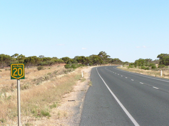
Rare NH20 trailblazer between Euston and Buronga, January 2004.
Length: 605km
Eastern Terminus: Hume Highway, 9km N Tarcutta
Western Terminus: George Chaffey Bridge over Murray River, Buronga (NSW/VIC Border)
Interstate Continuation: Sturt Hwy continues west through VIC/SA to Adelaide
Focal Points: Gundagai, Wagga Wagga, Narrandera, Hay, Balranald, Euston, Mildura
RTA Internal Classification: State Highway 14
Proclaimed a state highway: August 1933
Named: August 1933 (named Sturt Trunk Rd in 1930)
Route Overview:
The Sturt Highway in NSW is a major east-west through the Murray-Riverina region. As a whole, the Sturt Hwy forms the Sydney-Adelaide National Highway link and carries the NH20 shield throughout NSW, while the Victorian and SA sections now carry the A20 designation. Before 1998, NH20 used to extend all the way from the Hume Hwy to Adelaide along the Sturt Hwy but the introduction of alpha-numeric numbering in Victoria and South Australia means that NH20 now only exists in NSW. Within NSW it remains largely unchanged from its original alignment.
Having travelled the length of the Sturt Hwy in NSW i can assure you that it is of the highest quality, with only a few narrow sections across the Hay Plains. 110km/h conditions are encountered west of Hay.
Im 1928, at the dawn of road classification in NSW, the Sturt Hwy as whole did not exist. Parts of the current route existed, the Hume Hwy to Wagga Wagga section was part of State Highway 4 (Snowy Mtns Hwy) and the Balranald to Buronga section was part of State Highway 6 (Mid Western Hwy) which extended west to the SA border near Renmark, a route which the Sturt Hwy would later traverse. In 1929, the Wagga Wagga to 58km W of Hay section was proclaimed Trunk Road 58 and named Sturt Trunk Road in 1930. The remaining section fo the current route from Hay to Balranald did not exist.
A major overhaul came in August 1933 when all these parts were proclaimed State Highway 14, from Hume Hwy to the SA Border near Renmark. This newly proclaimed highway was named Sturt Highway after Captain Charles Sturt who explored the area in 1829 and opened it up for agriculture. In 1939, the Sturt Hwy was truncated at Buronga and the Buronga-Wentworth section reclassified as Main Road 69 (later Silver City Hwy) and the Wentworth-SA section reclassified as MR68. This rationalisation took place so that the Sturt Highway name would apply to the shortest and highest standard route between Sydney and Adelaide.
In 1938, the Sturt Highway was completely reconstructed between the Hume Hwy and Balranald to bring it up to rural highway standards. In 1955, the Sturt Highway was rewarded with the National Route 20 shield as one of the first 5 National Routes to be signposted. Completion of a bitumen surface along its entire NSW length was achieved in 1962, following the completion of a major reconstruction programme. Since then, the only major upgrade has been the Guys Hill Deviation (22-29km W of Hume Hwy), which opened to traffic in November 1975.
In 1992, the Sturt Highway was proclaimed a National Highway, forming the Sydney-Adelaide Link. The black and white shield was subsequently replaced with the green & gold shield. NH20 only remained an interstate route for a few years, as in 1999 Victoria rebadged their section as the A20 with SA following suit in 2001. Remnants of the pre-alpha numeric shields can still be found, albeit in decreasing numbers.
Notable events in the history of NH20:
1882 - Old bridge over Murrimbidgee River, Blaranald
1924 - Old bridge over Murray River, Buronga
1928 - Hume Hwy to Wagga Wagga section proclaimed part of State Highway 4 (Snowy Mtns Hwy) and the Balranald to Buronga section proclaimed part of State Highway 6 (Mid Western Hwy).
1929 - Wagga Wagga to 58km W Hay section proclaimed Trunk Road 58
1930 - Wagga Wagga to 58km W Hay section named Sturt Trunk Road
August 1933 - Proclaimed State Highway 14 & named Sturt Highway from Hume Hwy to SA border near Renmark
1938 - Completely reconstructed between Hume Hwy and Balranald
1939 - Buronga to SA Border section of Sturt Hwy decomissioned, truncating the highway st Buronga
1955 - National Route 20 signage erected (Hume Hwy to Adelaide)
1962 - sealing and reconstruction completed
June 1973 - Murrumbidgee River Bridge, Balranald
November 1975 - Guys Hill Deviation (22-29km W of Hume Hwy)
1976 - Edward Street railway underpass (Wagga Wagga) opened
1985 - George Chaffey Bridge over Murray River, Buronga
1992 - Proclaimed a National Highway for its entire length (Hume Hwy to Adelaide)
Jan 1993 - Newell Hwy duplex reclassified as State Highway No. 17 (Newell Hwy)
1995 - Hume Hwy intersection grade-separated
December 1999 - Euston Roundabout
1999 - Victorian section of NH20 re-badged as A20
2001 - South Australian section of NH20 re-badged as A20
Dec 2001 - Yarragundry re-alignment
2003 - Sandigo re-alignment
Further reading (on-site):
Remnants of National Route 20 in NSW
Further reading (off-site):
Sturt Highway (NSW) - Michael Greenslade
Photos of Sturt Highway |
|
 |
Hume Highway southbound approaching the beginning of Sturt Highway near Tarcutta. Jan 2004. |
 |
Erroneous NH20 shield on the northbound Hume Hwy distance sign at the Sturt Hwy junction. Jan 2005. |
 |
Northbound Hume Highway approaching Sturt Hwy. Feb 2006. |
 |
AD sign eastbound on Sturt Hwy approaching Hume Hwy. Jan 2005. |
 |
The first distance sign heading west from Hume Highway. Feb 2006. |
 |
Fingerboard signage at Lower Tarcutta Rd. Feb 2006. |
 |
Section of old Sturt Highway (Wokolena Rd) at Guys Hill (22-29km west of Hume Hwy). Feb 2006. |
 |
Surviving yellow line-markings on old Sturt Highway at Guys Hill. Feb 2006. |
 |
Tight bend with old wooden fence pots (but no fence!) and yellow line-markings on old Sturt Hwy at Guys Hill. Feb 2006. |
 |
A good view of just how narrow the old alignment of the highway is - this is reminiscent of 1950s and earlier standard of highway construction. Feb 2006. |
 |
Freshly resealed section of the old highway, heading west approaching the current alignment. Feb 2006. |
 |
Looking east along the Guys Hill deviation, which replaced the section of road depicted in the above 5 photos. Jan 2005. |
 |
Looking east at the cutting on Guys Hill deviation. Jan 2005. |
 |
Distance sign heading east from Tumbarumba Road at Alfredtown. Jan 2005. |
 |
Westbound AD sign for Tumbarumba Road at Alfredtown. Feb 2006. |
 |
Looking east along a nice tree-lined section of the Sturt Highway at Gumly Gumly. Jan 2005. |
 |
Another tree-lined section on the eastern outskirts of Wagga Wagga, near Eunony Bridge Rd. Jan 2005. |
 |
Distance sign heading east from Wagga Wagga, near Kooringal Rd. Jan 2005. |
 |
The Sturt Highway through Wagga Wagga has had a recent signage upgrade (2003/2004) and with it came these unusual AD signs. Whats unusual about them is that they don't include proper focal points for the Sturt Hwy (eg. Narrandera) but rather just "Hospital" or some other service. I'm not sure I agree with it, I would like to see Narrandera and NH20 on this sign as well. Feb 2006. |
 |
Looking east under the Main Southern Railway line near Tarcutta Street. This was once a level crossing (until 1976) and you can clearly see how the Sturt Hwy has been lowered beneath the railway line. Jan 2005. |
 |
Another of the AD signs without mention of NH20, Sturt Hwy or Narrandera. This one is located at Edmondson St. Feb 2006. |
 |
Here we are, back to normal. Westbound AD sign approaching Docker Street. Feb 2006. |
 |
Eastbound AD sign for the eastern junction with Olympic Highway. Feb 2006. |
 |
Distance sign heading west from Olympic Highway along the NH20/NR41 duplex. Note the use of both highway names, good for navigational purposes (despite the fact this section is only part of Sturt Highway by legal definition). Feb 2006. |
 |
Similar style distance sign, this time heading east from Olympic Hwy along the NH20/NR41 duplex. Feb 2006. |
 |
Westbound AD sign approaching the western junction with Olympic Highway. Feb 2006. |
 |
ID sign assembly at the western junction with Olympic Highway. Jan 2004. |
 |
Distance sign heading west from Olympic Highway. Feb 2006. |
 |
Distance sign heading east from Collingullie. Jan 2005. |
 |
Distance sign heading west from Collingullie. This is poor signposting, as the focal points mentioned on the previous distance sign are not followed up on this one. Whatever happened to consistency? Jan 2004. |
 |
Westbound AD sign for the Coolamon turnoff, 2km west of Collingullie. Jan 2004. |
 |
One of the several signs warning motorists not to bring fruit into the fruit fly exclusion zone - westbound near Galore. Jan 2004. |
 |
Extremely rare black AD sign on the Lockhart-Kywong road approaching Sturt Hwy at Kywong. Jan 2004. |
 |
Distance sign heading west from Kywong, with again only one focal point. Jan 2004. |
 |
Looking west across a newly reconstructed and realigned section of Sturt Highway at Sandigo. Jan 2004. |
 |
Rather oversized fingerboard sign with an oddly-shaped NH20 shield at the Boree Creek turnoff near Sandigo. Jan 2004. |
 |
Tourist sign welcoming motorists to the Murrimbidgee Irrigation Area, 4km east of Narrandera. Jan 2004. |
 |
Load limit signage on Sturt Highway heading west from Narrandera. Jan 2004. |
 |
Westbound approaching the Newell Highway junction at Gillenbah. Jan 2004. |
 |
Rare dual-highway name signage at the eastern junction with Sturt Hwy at Gillenbah. Until January 1993, this 500m section of road was classified as part of State Highway No. 14 (Sturt Hwy) but is now part of State Highway No. 17 (Newell Hwy). Sensibly, this sign shows both highway names so that travellers looking for the Sturt Hwy don't get confused when they see only the Newell Hwy name. Jan 2004. |
 |
AD sign westbound on Newell Hwy approaching the western junction with Sturt Hwy at Gillenbah. Jan 2004. |
 |
AD sign eastbound on Sturt Hwy approaching the junction with Newell Hwy at Gillenbah. Jan 2004. |
 |
ID sign assembly at the western junction of Newell and Sturt Highways, Gillenbah. Jan 2004. |
 |
Distance sign heading west from Gillenbah. Jan 2004. |
 |
Diagrammatic AD sign southbound on Kidman Way approaching the dog-leg at Sturt Hwy at Waddi. Jan 2004. |
 |
Distance sign heading west from Waddi. Jan 2004. |
 |
Westbound AD sign for Carrathool turnoff. Jan 2004. |
 |
RTA maintenance marker which looks awfully like a National Route shield - you would think they could have chosen a different shape sign! Midway between Carrathool turnoff and Hay. Jan 2004. |
 |
AD sign informing motorists to follow NH20 route markers to reach Adelaide. The RTA usually uses these signs when there is a complex urban area ahead, and where it may not be practical to include "Adelaide" on every directional sign. In this case, it is only a roundabout :-s Jan 2004. |
 |
Eastbound AD sign approaching the roundabout junction with Cobb Highway at South Hay. Mid Western Highway begins a short distance into town, hence its mention on this sign. Jan 2004. |
 |
Another silly-looking maintenance marker, this time between Hay and Balranald. Jan 2004. |
 |
The last of the silly-looking maintenance markers between Hay and Balranald. Jan 2004. |
 |
ID sign at the junction with Main Road No. 67 (Swan Hill-Ivanhoe road) in Balranald. Jan 2004. |
 |
Westbound AD sign approaching the Murray Valley Highway/NR16 near Robinvale. Jan 2004. |
 |
Northbound Murray Valley Hwy approaching Sturt Highway near Robinvale. Jan 2004. |
 |
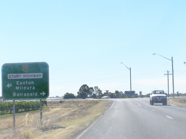
Distance sign heading west from Murray Valley Hwy towards Euston. Jan 2004. |
 |
AD sign westbound in Euston approaching the roundabout with Murray Tce. Jan 2004. |
 |
Distance sign with NH20 on a coverplate over NR20, heading west from Euston. Jan 2004. |
 |
Victorian style tourist sign welcoming motorists to the Sunraysia region, between Euston and Buronga. Jan 2004. |
 |
NH20 trailblazer, a rarity in NSW, between Euston and Buronga. Photo taken January 2004. |
 |
Oh look! another one! this time heading west near Trentham Cliffs. Photo taken January 2004. |
 |
Westbound AD sign approaching the junction with Silver City Highway at Buronga. Note the signposting of NR79 - which should cross the border into Victoria via Abbottsford Bridge at Curlwaa. Perhaps this is a deliberate ploy by the RTA to connect NR79 with another National Route since the Victorian leg of NR79 became A79 in 1998. Jan 2004. |
 |
Eastbound AD sign for the junction with Silver City Highway at Buronga. Jan 2004. |
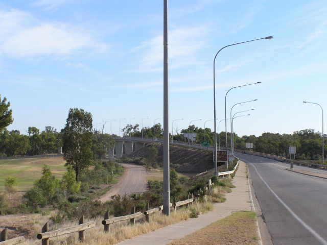 |
Looking east from Victoria to the Murray River (George Chaffey Bridge) and NSW Border. Jan 2004. |