M2 HILLS MOTORWAY
Built on the Castlereagh Freeway reservation

Looking west at the Beecroft Road interchange, Cheltenham. April 2005.
Length: 20km
Eastern Terminus: Epping Road, North Ryde
Western Terminus: Old Windsor Rd & Abbott Rd, Winston Hills
Route Markers: Metroad 2
Tolls Payable: $4.95 (main toll plaza - North Ryde), $2.75 (west facing ramps - Pennant Hills Rd), $1.87 (west facing ramps - Windsor Rd)
Roads Act 1993 classification: Freeway No. 6002
Opened to traffic:
Epping Road to Abbott Road -
26 May 1997
Windsor Road, west-facing ramps - 25 July 20121
History:
The M2 Hills Motorway is a privately owned motorway extending from Epping Road at North Ryde to Old Windsor Rd at Abbott Rd, Winston Hills, and forms part of the Sydney Orbital motorway system. It is not possible to travel on the motorway without paying the toll, unlike the M4, Harbour Bridge/Tunnel or Eastern Distributor. The main toll plaza is located at North Ryde with additional toll plazas on the west-facing ramps at Pennant Hills Rd, Carlingford. West facing ramps are provided at Christie Rd/Herring Rd, Lane Cove Rd & Dehli Rd - all in North Ryde - while east facing ramps are provided at Beecroft Rd and Windsor Rd. A full diamond interchange at Pennant Hills Rd is the only of its type along the motorway. The M2 also includes a busway - the right lanes of both carriageways - between Windsor Rd and Beecroft. Special bus-only exit ramps are provided at Pennant Hills Rd and Windsor Rd while a special flyover at Beecroft Rd takes buses to Epping Station. Two bus stops are provided in the centre of the motorwway - at Oakes Rd and Barclay Rd.
The M2 was constructed as a privately owned tollway on the F2 - Castlereagh Freeway reservation that had been intact for over 30 years. The Castlereagh Fwy corridor was not included in the County of Cumberland Planning Scheme in 1951 as most of the area it now serves was to be part of the Green Belt - a ring of open space around the proposed limit of suburban expansion. The Green Belt concept was abandoned in the 1960s and in 1967 the DMR included the Castlereagh Expressway in its freeway proposals for the following reasons:
1. To service land released from the Green Belt for urban purposes
2. To provide an all-weather route bypassing the flood-liable basin of Windsor-Richmond
3. To provide a link from Springwood to Bells Line of Road
4. To provide a mountain route from Mt Druitt which could form the basis of a National Route to Broken Hill and to Perth
5. The Maraylya area dotted in 1968 in the Sydney Region Outline Plan and subsequently included as a future urban area in the SATS (Sydney Area Transportation Study) has significance for the Castlereagh Freeway
In 1968 the proposal made its debut in the Sydney Region Outline Plan (1968) and was followed up by inclusion in the Ryde and other municpal planning schemes. The reservation identified extended from the proposed Lane Cove Valley Expressway near Herring Road, North Ryde, west along the current M2 and M7 corridors to Dean Park. From there it would skirt the north of the Mount Druitt area en route to Springwood and Bells Line of Road. As far as i know the precise route of the proposed expressway was never determined west of The Northern Rd.
This particular expressway remained rather unnoticed during the period of anti-freewayism in the late 70s - the F2 only coming to the fore in the mid-1980s. The DMR's failure to construct the expressway in time to meet the traffic needs of the Quakers Hill urban release area attracted stinging criticism from western Sydney councils in a 1985 report on road funding and planning in western sydney. Proposals for construction of the expressway were rejected by the State Government in 1987 but a change of government meant that several studies were undertaken in subsequent years investigating the need and impacts of constructing the freeway between Epping Rd and Pennant Hills Rd. The Lane Cove Valley Expressway had been abandoned between North Ryde and Drummoyne in 1977 so the Castlereagh Freeway reservation usurped the former LCV reservation between Herring Rd and Epping Rd, North Ryde. The DMR exhibited an EIS for the Pennant Hills Rd to Epping Road stage in June 1989 and this was followed up by a Commission of Inquiry for Environment and Planning in July 1990. The Inquiry put forward the following recommendations:
"1. The proposed Expressway known as the F2 Stage 1 between Pennant Hills Rd, Beecroft, and Epping Road near the Channel 10 site at Ryde [should] not be constructed by reason of findings of this Commission of Inquiry
2. An alternative upgrading of the existing east-west road system between Pennant Hills Rd and Epping Rd near the Channel 10 site together with other measures including improvements in public transport during peak periods be implemented as a matter of high priority. There is an immediate need to cease peak hour traffic congestion in the east-west corridor from Pennant Hills Rd eastward.
3. The recommended alternative road upgrading would involve -
- As first priority, the initial construction of a bypass near Epping Bridge linking Carlingford Rd to Epping Rd and the widening of Epping Rd near the Epping Bridge to six lanes so that Epping Rd has six lanes for its entire length. Subject to feasibility study, the Commission favours a tunnel linking Carlingford and Epping Roads via Pembroke Street. It should be noted that Epping and Carlingford Roads would continue to be busy roads carrying high volumes of traffic in peak periods even if the expressway is built.
- Upgrading of Epping Road and Carlingford Rd on a staged basis. Widening of Carlingford Rd, an interchange at Pennant Hills Rd and improvements to intersections on Epping Rd would be required over time.
- Local traffic measures to restrict through traffic in peak periods on local streets including Sutherland Road."2
Despite these strong recommendations against construction of the expressway, in September 1990 the RTA commissioned two new Environmental Impact Statements to investigation ALL transport options between Old Windsor Rd and Epping Rd. In May 1992 the EISs were exhibited for public comment and the the RTA received a staggering 14,000 submissions - the most ever received. After considering all the submissions made the RTA's Chief Executive issued the Determination for the project to proceed in May 1993. Minister for Transport and Roads, Bruce Baird, announced the road would go ahead as a BOOT project on the 29 May 1993 at Epping West Primary School on Carlingford Rd, the subject of unbearable traffic congestion at most hours of the day. Construction was commenced towards the end of 1993 and the motorway opened to traffic in May 1997 with a $2.50 toll at the North Ryde plaza.
One of the failures of the M2 Motorway when it first opened was the lack of motorway connections at either end. Both at Winston Hills and North Ryde, traffic was dumped onto arterial roads at signalised intersections - therefore restricting the operating throughput capacity and reducing the benefits of any time savings made from using the motorway. Since then, the Westlink M7 motorway has been constructed (opened 16 December 2005), extending the motorway conditions along the former Castlereagh Freeway (F2) reservation to Richmond Road at Oakhurst, as well as south to near Liverpool. The construction of this particular section of the motorway (Old Windsor Rd to Richmond Rd) was referred to in the May 1985 regarding road funding and planning in western Sydney, thus it is some late justice that the motorway was eventually constructed 20 years later. At its eastern end, the M2 dumped traffic onto the 6-lane Epping Road which handles the pressure of very high peak traffic volumes through the use of a tidal flow system, introduced in March 1990. Construction of the Lane Cove Tunnel, to take through traffic underneath Epping Road and directly to the Gore Hill Freeway at Artarmon, was commenced in 2004 and should be completed by the end of 2006.
There have been proposals for the construction of a Bells Line Motorway or Blue Mountains Motorway, which would replace the Great Western Highway as the major route across the Blue Mountains. This motorway would most likely follow the Bells Line of Road and connect to Sydney's orbital motorway system via the Castlereagh Freeway (F2) reservation, which exists from Richmond Road at Oakhurst as far as Londonderry Road, Londonderry, if not as far as Springwood Road, Yarramundi. However, this project appears to have attracted little interest from the NSW Government who is currently investing large amounts of money into upgrading the Great Western Highway.
Photos of the M2 Hills Motorway |
|
 |
Heading west on Epping Rd at Stringybark Creek - this is the first mention of the Motorway. Sep 2003. |
 |
Across the other side of the creek and we have another AD sign for the motorway beginning just a little further ahead. Feb 2006. |
 |
The gantry sign that used to signal the beginning of the M2 Motorway at North Ryde. This has since been removed due to Lane Cove Tunnel works. Aug 2004. |
 |
Trucks carrying dangerous goods are not permitted in the M2 Tunnel at Epping and thus cannot use the motorway east of Pennant Hills Road. Signs similar to this one appear at every interchange east of Pennant Hills Road. March 2006. |
 |
The opening stretch of the M2 Motorway, looking west. This section is located in a trench between the two carriageways of Epping Road. March 2006. |
 |
The first westbound distance sign on the motorway. It is unusual that Beecroft is preferred over another destination (such as Windsor) that is more important. April 2005. |
 |
Lane allocation AD sign westbound on Dehli Road approaching the M2 at North Ryde. June 2006. |
 |
Distance sign for eastbound traffic as you pass under Dehli Road at North Ryde. Jan 2006. |
 |
Heading south through Macquarie Park (North Ryde) approaching Dehli Road, which is the last eastbound exit on the M2. Traffic must also use Dehli Road to reach Mowbray Road, as the M2 merges into the centre of Epping Road. Jan 2006. |
 |
Distance sign heading north from Dehli Road. Now that there is no height clearance to worry about, Windsor has been added as the final focal point. Note how Pennant Hills Rd now has Metroad 6 shield as well as a Metroad 7 shield. Jan 2006. |
 |
Lane Cove Road northbound approaching the M2 interchange at Macquarie Park (North Ryde). Dec 2005. |
 |
Lane Cove Road southbound approaching the M2 interchange at Macquarie Park (North Ryde). Note the additional Sydney sign - traffic cannot access the M2 eastbound here, instead they must use Lane Cove and Epping Roads through North Ryde. May 2004. |
 |
Eastbound AD sign for Lane Cove Road interchange at Macquarie Park (North Ryde). Note the ridiculously small "Sydney Olympic Park" legend. Jan 2006. |
 |
Looking east from the Christie Road overpass at Macquarie Park, showing the ramp from Herring Road onto the westbound M2 Motorway. Note the blue sign which is little more than advertising for a ROAM E-tag. June 2006. |
 |
ID signs at the intersection of Talavera & Herring Roads, Macquarie Park, which is the commencement of the Herring Road on-ramp onto the M2 Motorway. June 2006. |
 |
Toll charges and e-tag signage for the M2 toll booths on the Herring Rd on-ramp at Macquarie Park. June 2006. |
 |
Looking east from the Culloden Rd overpass at Macquarie Park, showing the M2 toll booths, complete with express lanes (E-tag only) that were completed in about February 2006. June 2006. |
 |
Westbound AD sign for the Beecroft Rd interchange, just before you cross Terrys Creek into North Epping. Jan 2006. |
 |
Looking east into the Epping Tunnel. Jan 2006. |
 |
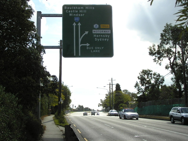
Distance sign heading west at the Beecroft Road interchange. It is unusual that this sign is located before the Beecroft Road overpass, however there is no westbound on-ramp so I guess it doesn't matter. Jan 2006. |
 |
Beecroft Rd southbound approaching the M2 interchange at Cheltenham. May 2004. |
 |
Looking east to the Beecroft Road interchange, showing the bus only lanes leave the motorway bound for Epping Railway Station. Jan 2006. |
 |
The first mention of Pennant Hills Road interchange, westbound at the Kent St footbridge. Note that Liverpool and Canberra have both been coverplated since the opening of the Westlink M7. Jan 2006. |
 |
Very large distance sign heading east from the Pennant Hills Road interchange. Jan 2006. |
 |
The first diagrammatic AD sign for Pennant Hills Road interchange. Note the M7 route marker, which has been signed along the M2 west of Pennant Hills Rd. Jan 2006. |
 |
ID sign at the Pennant Hills Rd interchange showing the Metroad 2/M7 duplex. Also note the new remote focal point of Canberra! March 2006. |
 |
AD sign southbound on Pennant Hills Road approaching the M2 interchange. Note that Liverpool is signed straight ahead and there is no mention of Canberra or route M7 for the right turn! Not happy RTA! March 2006. |
 |
Looking west from the Pennant Hills Road overpass, showing the toll booths for the west-facing ramps. March 2006. |
 |
Eastbound AD sign for the Pennant Hills Road interchange. This is the northern terminus of route M7, as well as the northern terminus of Metroad 6 and the southern terminus of Metroad 6! Jan 2006. |
 |
The first westbound AD sign for the Windsor Road interchange at Baulkham Hills. Note that Windsor is now signed straight, formerly it was signed via Windsor Road (because Old Windsor Road still had a load limit north of Sunnyholt Rd). Jan 2006. |
 |
Looking west to the Windsor Road interchange at Baulkham Hills. Note the centre ramp which allows buses to direct access to/from Windsor Road. This is also the western extremity of the bus lanes, which merge into general traffic just beyond the overpass. Jan 2006. |
 |
Distance sign heading west from the Windsor Road interchange. Note the gluttony of route markers on this sign! Jan 2006. |
 |
AD sign northbound on Windsor Road approaching the M2 interchange. Unfortunately this was the best shot I could manage with the sun directly behind the signface. May 2006. |
 |
This is the first of the M7 signage, westbound between Watkins Rd and Cropley Dr, Baulkham Hills. Now that the M7 has been opened, motorists have so mnay choices of where to exit to reach Blacktown! Jan 2006. |
 |
Looking east between Cropley Dr and Watkins Rd at Baulkham Hills. For some reason the M2 has been squashed into a narrow reservation between Windsor Road and Toongabbie Creek, with the result that there are no bus lanes and no room for widening! Jan 2006. |
 |
The last westbound distance sign on the M2 Motorway, nice and simple. Jan 2006. |
 |
This is the first mention of the Abbott Road exit, which is the terminus of the M2 Motorway. Straight ahead the Westlink M7 beckons. Note that Metroad 2 is signed both straight ahead and left - this is because M2 is under the top coverplate and A40 is under the lower coverplate. For now, it makes an interesting little triangle at between Old Windsor Road, the Westlink M7 and Abbott Road. Jan 2006. |
 |
A cantilvered sign warning westbound M2 traffic that Abbott Road is the last exit before the Westlink M7 (and thus another toll) begins. Jan 2006. |
 |
The second diagrammatic AD sign for the Abbott Road interchange. As you can see, Windsor is signed straight ahead (Old Windsor Rd northbound can be accessed via the M7) but I fancy plenty of motorists will exit here to save an extra 50 cents. Also, the Westlink M7 is off-limits for those without an E-tag. Jan 2006. |
 |
Poor angle on this photo, showing the first eastbound distance sign on the M2 Motorway. This sign used to be located on the mainline mtoroway, but as part of the construction of the M7 it has since become an on-ramp. Thankfully there is a distance sign about 1km earlier for Westlink M7 traffic. Jan 2006. |
 |
ID signs at the junction of Old Windsor Rd and Abbott Road, pointing to the entrance to the M2 Motorway. March 2006. |
 |
Abbott Road eastbound approaching the beginning of the M2 Motorway at Seven Hills. Note the M7 shield (next to the Metroad 2 shield straight) has been strangely coverplated and there is a stray State Route 40 shield. This is an error - Old Windsor Rd is to become route A40 when alpha-numeric route marking is introduced. March 2006. |
 |
Old, pre-M7 signage, northbound on Old Windsor Rd approaching the beginning of the M2 Motorway at Seven Hills. March 2005. |
1. 'M2 opened to The Hills with new access ramps' in Hills News (Online), 25 July 2012. Available from: http://www.hillsnews.com.au/news/local/news/general/m2-opened-to-the-hills-with-new-access-ramps/2635444.aspx
2. Woodward J. - Commissioner of Inquiry for Environment and Planning; “A proposed Expressway from Pennant Hills Rd, Beecroft to Pittwater Rd, Ryde known as the F2 Stage 1 - Report to Minister for Local Government and Minister for Planning”; July 1990; p.1-6
Last updated 18 August 2012 © Ozroads 2003-2012. |