State Route 66 East Parade & Plain Street |
East Parade southbound approaching Brook Street, East Perth, showing SR66 continuing along Plain Street. Photo taken: May 2010.
Introduced: 2000
Length: 2km
Northern Terminus: Guildford Road, East Parade & Whatley Crescent, Mount Lawley
Southern Terminus: Plain Street, Wellington Street & Waterloo Crescent, East Perth
Route taken: East Parade, Plain Street
Focal Points: Mount Lawley, East Perth, Causeway
Main Roads Act 1930 classifications: H26 (Guildford Road to Graham Farmer Freeway) - remainder of route is on local roads
Description:
State Route 66 is a short connecting route through East Perth, running along East Parade and Plain Street. It was introduced in conjunction with the opening of the Graham Farmer Freeway primarily to provide a link between the freeway and Guildford Road. It also provides a link from the to the Causeway, although signposting south of Brook Street is lacking.
Signposting along most of the route is excellent, however there are a couple of key problems:
-
Due to the prohibition of right turns at the Guildford Road/East Parade intersection, northbound traffic must use Whatley Crescent and First Avenue to reach Guildford Road east, however this is not signposted until after you pass through the intersection.
-
There is no signage referring to State Route 66 whatsoever at the intersection of Plain Street and Wellington Street - the southern terminus of the route.
History:
East Parade was originally a typical two-lane street through the industrial wasteland that was East Perth, serving the gas works, power station and locomotive depot.
Major work was undertaken on the route during the mid-to-late 1960s, in conjunction with the redevelopment of the former East Perth Locomotive Depot and other railway related redevelopment. This work included reconstructing East Parade into a four-lane divided carriageway between Zebina and Summers Streets, a four-lane undivided carriageway south of Summers Street, replacement of the railway level crossing with an overpass and the connection of East Parade to Plain Street.
In 1978/79, East Parade was widened to four lanes north of Zebina Street and the intersection with Guildford Road was reconstructed, including the provision of the loop allowing traffic from Guildford Rd west to access East Parade.
As part of the landmark East Perth redevelopment project in the early 1990s, East Parade and Plain Street were reconstructed between Kensington and Wittenoom Streets. This work included a bridge over 'Claisebrook Cove' and the public art in the roundabout island at Brook Street.
As part of construction of the Graham Farmer Freeway, between 1996 and 2000, East Parade was reconstructed between Summers and Kensington Streets to accommodate the freeway interchange. The existing bridge over the railway line was retained and modified for the northbound carriageway with a new structure constructed for southbound traffic.
References:
Landgate aerial photography, 1953 - 2011
|
Photos of State Route 66 |
|
 |
AD sign eastbound on Guildford Road, approaching East Parade at Mount Lawley. Due to the angle of the intersection and the restricted width available below the railway line, traffic wanting to turn right onto East Parade must pass through the intersection then turn left, looping around onto Whatley Crescent southbound. |
 |
ID sign facing eastbound traffic on Guildford Rd, just east of the junction with East Parade. Traffic turning left here loops onto Whatley Crescent, feeding directly into East Parade southbound. |
 |
ID sign assembly westbound on Guildford Rd, approaching East Parade at Mt Lawley. |
 |
AD sign acting as an RD sign northbound on Whatley Crescent, just north of Guildford Road, guiding traffic towards the access to Guildford Road eastbound (via First Avenue). No right turns are permitted on any approach to this intersection. |
 |
State Route 51 trailblazer northbound on East Parade approaching Guildford Road. This is slightly misleading as the sign directing traffic to Guildford Road east is not seen until after you pass through the intersection. Also note the absence of an 'END SR66' trailblazer. Photo taken: April 2011. |
 |
East Parade looking south near Pakenham Street, Mount Lawley. Note the wide reservation on the eastern (left) side of the road - all but one house has been demolished to make way for future road widening. Note that this widening has already taken place south of Zebina Street. Photo taken: April 2011. |
| East Parade looking north through East Perth. The building on the left is the Public Transport Centre, which was constructed on land freed up by the closure and demolition of the former East Perth Locomotive Depot in the 1960s. | |
 |
AD sign southbound on East Parade approaching the Graham Farmer Freeway interchange. Photo taken: April 2011. |
AD signs eastbound on the Graham Farmer Freeway approaching the East Parade interchange. The first two photos are located on the ramps from Mitchell Freeway south and Mitchell Freeway north, respectively. |
|
 |
AD sign eastbound on the ramp from Lord Street to East Parade, alongside the Graham Farmer Freeway. Photo taken: February 2011. |
 |
ID sign facing eastbound traffic at the East Parade/Graham Farmer Freeway interchange. Photo taken: April 2011. |
 |
Overhead signage westbound on Graham Farmer Freeway approaching the East Parade interchange, as you cross Windan Bridge over the Swan River. Photo taken: May 2011. |
 |
AD sign on the westbound off-ramp from Graham Farmer Freeway to East Parade. The ramp continues alongisde the freeway to the intersection of Lord & Newcastle Streets, while also providing access onto the freeway westbound. Photo taken: May 2011. |
 |
ID sign assembly facing westbound traffic at the East Parade/Graham Farmer Freeway interchange. Photo taken: April 2011. |
 |
East Parade looking north towards the Graham Farmer Freeway interchange from the Kensington Street intersection, East Perth. Note the line of traffic waiting to turn right onto the freeway. Photo taken: May 2010. |
 |
East Parade southbound approaching Brook Street, East Perth, showing SR66 continuing along Plain Street. Photo taken: May 2010. |
 |
Public art in the roundabout island at the intersection of East Parade, Plain Street & Brook Street, East Perth. Photo taken: May 2010. |
 |
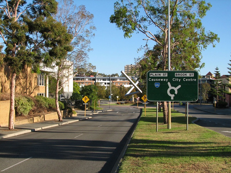
ID sign at the intersection of East Parade, Plain Street & Brook Street, East Perth, showing SR66 continuing south along Plain Street. Photo taken: May 2010. |
 |
Plain Street looking north at Wickham Street, East Perth. The Royal Street shopping/cafe strip is located at the bottom of the hill. Photo taken: May 2011. |
 |
State Route 65 trailblazer southbound on Plain Street, approaching Wellington Street, East Perth. This is the southern terminus of State Route 66 but, as you can see, there are no SR66 signs to be seen! Photo taken: May 2011. |
 |
State Route 65 trailblazer eastbound on Wellington Street, approaching Plain Street, East Perth. There should be a SR66 trailblazer pointing left at this location. Photo taken: May 2011. |
 |
Plain Street looking north towards the junction with Wellington Street & Waterloo Crescent, East Perth. Note the lack of route marker signs - no mention of SR66 (straight ahead) and good luck if you are following SR65 which turns left without any warning at this location. Photo taken: May 2011. |


Last updated 17 May 2011 © Ozroads 2004-2011. |