State Route 41 Kalamunda Road & Canning Road |
SR41 trailblazer southeastbound on Kalamunda Road, approaching Hawtin Road & Gooseberry Hill Road, Maida Vale. Photo taken: April 2011.
Introduced: 1986
Length: 23km
Northern Terminus: Roe Highway & Kalamunda Road, Maida Vale
Southern Terminus: Brookton Highway & Canning Road, Karragullen
Route taken: Kalamunda Road, Canning Road
Focal Points: Midland, Kalamunda, Kelmscott/Brookton
Main Roads Act 1930 classification: unclassified
Notable Events:
April 1986 - State Route 72 introduced1
Description:
State Route 41 is a north-south route through the Darling Range area, serving as the spine road for the Kalamunda, Lesmurdie, Pickering Brook and Karragullen districts. Aside from linking Kalamunda with the rest of Perth, via Roe Highway, the southern part of the route between Lesmurdie and Karragullen also provides an important heavy vehicle route between Brookton Highway and the Welshpool/Kewdale industrial area (via State Route 8).
Commencing at a junction with the Roe Highway in Maida Vale, State Route 41 extends southeast along the four-lane, divided Kalamunda Road to the foot of the Darling Scarp. After the junction with Gooseberry Hill Road, the route narrows to two lanes to ascend the scarp to Kalamunda town centre. A long climbing lanes is provided for southeastbound traffic on this section. After turning south onto Canning Road at Kalamunda, the route winds through suburban Lesmurdie and Walliston before taking on a semi-rural character. At Pickering Brook motorists need to be alert as the route makes a sharp right turn to head south towards Karragullen. No AD sign or trailblazer is provided on the approach to this junction, only ID signs, and I have witnessed several confused motorists miss the turn, only to do a u-turn a little way down Pickering Brook Road. South of Pickering Brook the route descends to cross Munday Brook before climbing back onto the ridge at Karragullen. After passing through the tiny Karragullen townsite, the route terminates at a junction with Brookton Highway, where motorists can either turn left for the 99km journey to Brookton or turn right to descend the scarp via Roleystone to Kelmscott.
History:
Coming soon...
Signage:
Signage along the route is generally of reasonable quality except for two very significant deficiencies. The first issue is at the junction of Kalamunda & Canning Roads in Kalamunda town centre where the turn is not signposted from either direction. The other issue is at the junction of Canning Road & Welshpool Road (State Route 8) at Carmel - no route markers or direction signs are provided at this junction at all! This is despite it being an important turnoff for motorists heading into Perth or entering the Darling Ranges via State Route 8.
Mapping errors:
Some street directories, including numerous editions of the UBD Perth Street Directoy, have incorrectly shown State Route 41 continuing northwest along Kalamunda Road from Roe Highway to Great Eastern Highway at South Guildford. As far as I am aware, State Route 41 was never planned to extend west of Roe Highway and has never been signed accordingly.
References:
1. Main Roads Department, Annual Report 1985/86, p. 16
|
Photos of State Route 41 (Maida Vale to Karragullen) |
|
 |
AD sign southbound on Roe Highway approaching the junction with Kalamunda Road, Maida Vale. |
 |
AD sign northbound on Roe Highway approaching the junction with Kalamunda Road, Maida Vale. |
 |
AD sign southeastbound on the unnumbered section of Kalamunda Road approaching the junction with Roe Highway, Maida Vale. Photo taken: April 2011. |
 |
ID sign facing southbound traffic at the junction of Roe Highway & Kalamunda Road, Maida Vale. |
 |
AD sign northwestbound on Kalamundra Road approaching the junction with Roe Highway. Note that Kalamunda Road continues as an unnumbered route through High Wycombe. Photo taken: April 2011. |
 |
Kalamunda Road looking south east towards the junction with Midland Road, Maida Vale. Photo taken: April 2011. |
 |
Kalamunda Road looking south east near the junction with Priory Road, Maida Vale. The school zone is for Maida Vale Primary School. |
 |
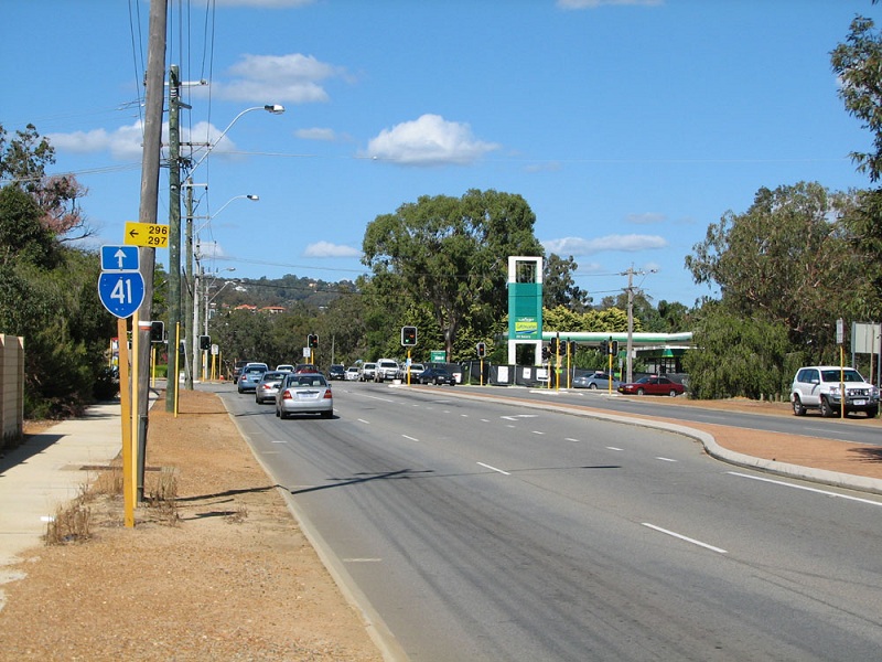
SR41 trailblazer southeastbound on Kalamunda Road, approaching Hawtin Road & Gooseberry Hill Road, Maida Vale. Photo taken: April 2011. |
SR41 trailblazer southbound on Gooseberry Hill Road approaching the junction with Kalamunda Road, Maida Vale. There is no corresponding trailblazer on Hawtin Road. Photo taken: April 2011. |
|
 |
ID sign facing northbound traffic at the junction of Kalamunda Road, Hawtin Road & Gooseberry Hill Road, Maida Vale. Photo taken: April 2011. |
 |
SR41 trailblazer northwestbound on Kalamunda Road approaching the junction with Hawtin Road (left) and Gooseberry Hill Road (right), Maida Vale. Photo taken: April 2011. |
 |
Kalamunda Road looking east at Nestle Brae Creek, showing signage welcoming motorists to the Perth hills area. Photo taken: April 2011. |
 |
Kalamunda Road looking west, east of Watsonia Road.
Photo taken: March 2011. |
 |
Kalamunda Road looking west, east of Gray Road, as you descend the Darling Range with the Perth CBD skyline in the background.
Photo taken: March 2011. |
 |
Kalamunda Road looking east towards Zamia Road as you climb the Darling Range.
Photo taken: March 2011. |
 |
Kalamunda Road looking west as you begin to descend the Darling Range near St Emilies Road, Kalamunda. Photo taken: April 2011. |
 |
Kalamunda Road looking east towards the junction with Stirk Street & Canning Road at Kalamunda. There is no direction signage location at this intersection so I hope you know you need to turn right to follow SR41. Photo taken: April 2011. |
 |
Canning Road looking north through Kalamunda town centre towards the junction with Kalamunda Road. Despite the lack of signage, SR41 turns left at this junction. Photo taken: April 2011. |
 |
Canning Road looking south from Haynes Street in Kalamunda town centre. Photo taken: April 2011. |
 |
Canning Road looking south at Cotherstone Road, Kalamunda. Photo taken: April 2011. |
 |
Canning Road looking south from Lesmurdie Road at Lesmurdie. Photo taken: April 2011. |
Canning Road looking south towards the junction with Grove Road at Lesmurdie. Photo taken: April 2011. |
|
 |
Canning Road looking south towards the staggered T-junctions with Carmel Road & Welshpool Road East at Carmel. Photo taken: April 2011. |
 |
Canning Road looking north to the junction with Welshpool Road East at Carmel. Note the ID sign showing 'truck route' - there is absolutely no direction signage at this junction despite being the terminus of SR8 and a major decision point for traffic bound for Welshpool and Perth. Photo taken: April 2011. |
 |
Truck route signage northbound on Canning Road approaching the junction with Welshpool Road East at Carmel. This is a major decision point for tourist and heavy vehicle traffic heading into metropolitan Perth. Photo taken: April 2011. |
 |
Canning Road looking south from Welshpool Road East at Carmel. Photo taken: April 2011. |
 |
Canning Road looking west towards the junction with Masonmill Road at Carmel. Masonmill Road was part of the original alignment of Canning Road. |
 |
Canning Road looking east, east of Masonmill Road, showing a section of the original alignment now in use as a service road. Photo taken: April 2011. |
 |
Canning Road looking west through the orchards between Masonmill Road and Glenisla Road, Carmel. Photo taken: April 2011. |
 |
Dodgy ID sign at the junction of Canning Road & Glenisla Road at Carmel. Bickley Valley is a popular wine tourism area. Photo taken: April 2011. |
 |
Canning Road looking southeast towards the junction with Pickering Brook Road at Pickering Brook. Canning Road and SR41 makes a right turn here to head south towards Karragullen. Photo taken: April 2011. |
   |
ID signs at the junction of Canning Road & Pickering Brook Road, Pickering Brook. Pickering Brook is an old timber milling area which is now largely a semi-rural dormitory for Perth. Top & middle photos: April 2011. Bottom photo: December 2010. |
 |
Canning Road looking north across Munday Brook, between Pickering Brook and Karragullen. Note the 'Road Closed' sign and the original alignment of Canning Road branching off to the left. The original route wound its way down to a low-level timber bridge across Munday Brook. Photo taken: April 2011. |
 |
Canning Road looking south through the semi-rural settlement of Canning Mills. Photo taken: April 2011. |
 |
Canning Road looking south towards O'Meagher Road at the Karragullen townsite. Photo taken: April 2011. |
 |
SR41 trailblazer facing northbound traffic just north of the Brookton Highway junction at Karragullen. Note the orchards to the right. Photo taken: April 2011. |
 |
AD sign southbound on Canning Road approaching the junction with Brookton Highway at Karragullen - the southern terminus of State Route 41. Note the use of Armadale rather than Kelmscott, which was shown on the previous sign. Photo taken: April 2011. |
 |
Trailblazer assembly, complete with 'END SR41', southbound on Canning Road approaching the junction with Brookton Highway, Karragullen. Photo taken: December 2010. |
  |
ID signs at the junction of Brookton Highway & Canning Road, Karragullen. Note the incorrect SR41 shield on the Brookton Highway sign - this should of course be SR40. Photos taken: April 2011. |
 |
Old black fingerboard signs at the junction of Brookton Highway & Canning Road, Karragullen. Photo taken: April 2011. |
 |
AD sign westbound on Brookton Highway approaching the junction with Canning Road, Karragullen. Note that Perth-bound traffic is not signed along this route despite being shorter than via Kelmscott. Photo taken: December 2010. |
 |
AD sign eastbound on Brookton Highway approaching the junction with Canning Road, Karragullen. Photo taken: April 2011. |
 |
Trailblazer sign assembly eastbound on Brookton Highway approaching Canning Road, Karragullen. Note the incorrectly placed arrow - it should be above the route marker. Photo taken: April 2011. |


Last updated 26 March 2012 © Ozroads 2003-2012. |