NSW MAIN ROAD No. 663
Menai to Sutherland
Length: 6km
Eastern Terminus: Princes Highway & Old Princes Highway & Acacia Rd, Sutherland
Western Terminus: New Illawarra Rd & Bangor Bypass, Menai
Route taken: Bangor Bypass, River Road, Linden St, The Grand Pde, Old Princes Hwy
Focal Points: Menai, Sutherland, Sydney
RTA Internal Classification: Main Road No. 663
Route Overview:
Main Road No. 663 is a mjaor east-west corridor in Sydney's south, connecting Metroad 1 with Metroad 6. It is also used as a circumferential route, with motorists preferring Alfords Point Bridge over Tom Uglys Bridge to cross the Georges River. The route is now largely complete, having evolved from a two-lane winding road since the 1980s. One possible extension has been touted to connect the Bangor Bypass with Heathcote to make a much shorter route from Sutherland to Liverpool. This proposal was marked in maps for several years but doesnt appear in the UBD directories anymore.
The original alignment can be traced by following today's "Menai Road", from the intersection with Alfords Point Road, east through Menai and Bangor. From Bangor, the old road is now a dead end, where the approaches to the new Woronora Bridge pass by in a deep cutting. The old road through Woronora still remains as an access road to the tiny community. On the east side of the river, the original roads have been widened, while a new concrete railway bridge carries traffic across the Illawarra railway line.
The first improvement to the route came in December 1986, with the opening of a four-lane bridge across the Illawarra rail line, connecting the Old Princes Highway with the Grand Parade. This project markedly eased congestion in Sutherland Town Centre, where previously traffic had to cross the rail line on a narrow bridge with 90 degree corners on its approaches. Further improvements were opened in June 1990, when a 1km section of Menai Road at Bangor was bypassed using Akuna Avenue as an interim route. This small project was technically Stage 1 of the Bangor Bypass, however, political issues delayed the completion of the full project. Daid Otto tells "the road from when it leaves River road to the Bangor Bypass (west of Akuna avenue) is (or at least was) known as the Menai Bypass. Yes, it went straight to Menai, but that's what they called it."
In February 2001 a new high-level four lane bridge across the Woronora River was opened to traffic. This bypassed not only the old low-level bridge, but bypassed the winding and narrow approaches on either side. Completed in conjunction with this process was the duplication of River Rd and Linden Street. However, this project only shifted the traffic bottleneck further west, as traffic still had to pas through congested two-lane sections of Bangor and Menai. In February 2005 the upgrading of this route was finally completed when the Bangor Bypass opened to traffic. The 3.4km bypass, commenced in January 2003, provides controlled-access conditions and connected to a concurrently-constructed section of New Illawarra Road (Metroad 6). It is now possible to travel all the way from Kirrawee to Menai on high standard four-lane road.
Notable events:
Dec 1986 - Sutherland Railway Overpass
Jun 1990 - Bangor Bypass Stage 1 (Menai Rd to Akuna Ave)
Feb 2001 - Woronora Bridge
Feb 2005 - Bangor Bypass completed
 |
Southbound on New Illawarra Rd approaching the beginning of the Bangor Bypass. Feb 2005. |
 |
Northbound on New Illawarra Rd approaching the beginning of the Bangor Bypass. Feb 2005. |
 |
Looking west at the end of the Bangor Bypass. Feb 2005. |
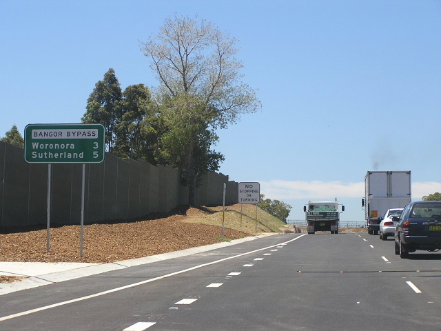 |
The eastbound distance sign at the beginning of the Bangor Bypass, Menai. Feb 2005. |
 |
Looking east along the Bangor Bypass. Feb 2005. |
 |
Looking west along the 70km/h Bangor Bypass. Feb 2005. |
 |
Heading west approaching the Akuna Avenue interchange on the Bangor Bypass. Feb 2005. |
 |
The old Main Road No. 663 - Menai Road - on the eastbound descent to cross the Woronora River. Feb 2005. |
 |
Looking east across the new Woronora Bridge. Feb 2005. |
 |
The old low-level Woronora Bridge. May 2005. Thanks to Lauren Zammit for this photo. |
 |
The new Woronora Bridge, taken from the old bridge. May 2005. Thanks to Lauren Zammit for this photo. |
 |
Looking east from the Woronora Bridge towards Sutherland. Feb 2005. |
 |
Looking south along Linden Street approaching The Grand Parade. Feb 2005. |
 |
Cantilevered signage on The Grand Parade, approaching Linden St. Feb 2005. |
Sign removed in 2000 advising of the narrow, winding route that the old road took prior to the opening of the new bridge. 1994. |
|
 |
Looking east from the Sutherland railway overpass along the Old Princes Highway. Feb 2005. |
 |
Signage at the Old Princes Highway offramp, Sutherland. Feb 2005. |
 |
Looking west along Old Princes Highway. Feb 2005. |
 |
Approaching Main Road No. 663 from Princes Highway southbound. Feb 2005. |
 |
Approaching Main Road No. 663 from Princes Highway northbound. Feb 2005. |